This article does not cite any sources . (March 2011) (Learn how and when to remove this template message) |
Melbourne Western Australia | |
---|---|
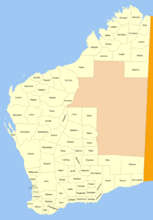
Melbourne Land District is a land district (cadastral division) of Western Australia, located within the South West Division.
The lands administrative divisions of Western Australia refer to subdivisions of the state of Western Australia for cadastral purposes, most of which have been in place since the 19th century. The state is divided up for this purpose into five land divisions, which in turn are subdivided into land districts, which correspond to counties in other Australian states. These districts are then subdivided further into numbered locations, as well as gazetted townsites. Together, they form part of the lands administrative divisions of Australia.
Western Australia is a state occupying the entire western third of Australia. It is bounded by the Indian Ocean to the north and west, and the Southern Ocean to the south, the Northern Territory to the north-east, and South Australia to the south-east. Western Australia is Australia's largest state, with a total land area of 2,529,875 square kilometres, and the second-largest country subdivision in the world, surpassed only by Russia's Sakha Republic. The state has about 2.6 million inhabitants – around 11 percent of the national total – of whom the vast majority live in the south-west corner, 79 per cent of the population living in the Perth area, leaving the remainder of the state sparsely populated.
Coordinates: 30°40′S116°10′E / 30.667°S 116.167°E
A geographic coordinate system is a coordinate system that enables every location on Earth to be specified by a set of numbers, letters or symbols. The coordinates are often chosen such that one of the numbers represents a vertical position and two or three of the numbers represent a horizontal position; alternatively, a geographic position may be expressed in a combined three-dimensional Cartesian vector. A common choice of coordinates is latitude, longitude and elevation. To specify a location on a plane requires a map projection.
This article about a location in Western Australia is a stub. You can help Wikipedia by expanding it. |
The County of Kara Kara is one of the 37 counties of Victoria which are part of the cadastral divisions of Australia, used for land titles. The northern boundary of the county is at 36°S. At the north its western boundary is 143°E. Larger towns include St Arnaud and Donald. The County was proclaimed in 1871 together with the other counties of the Wimmera Land District.
Mporokoso District is a district of Zambia, located in Northern Province. The capital lies at Mporokoso. As of the 2000 Zambian Census, the district had a population of 73,929 people.
Kalmani is a village in Belgaum district in Karnataka, India.
Dampier Land District is a land district of Western Australia, located within the Kimberley Division of the state.
Marndoc Land District is one of the land districts of Western Australia, located within the Kimberley Division of the state.
Bulga Land District is a land district of Western Australia, located within the Eastern Land Division.
Nuleri Land District is a land district of Western Australia, located within the Eastern Land Division.
Marmion Land District is a land district of Western Australia, located within the Eastern Land Division.
Hampton Land District is a land district of Western Australia, located within the Eastern Land Division in the Goldfields region of the state.
Not to be confused with the land district of the same name in New South Wales
Murray Land District is a land district of Western Australia, located within the South-West Land Division on the state's west coast. It spans roughly 32°25'S - 32°56'S in latitude and 115°25'E - 116°30'E in longitude, and is located on the Indian Ocean coast, taking in the Shires of Murray and Waroona, the eastern part of the Serpentine-Jarrahdale and the western suburbs of Mandurah.
Edel Land District is a land district of Western Australia, located within the North-West Land Division.
Murchison Land District is a land district of Western Australia, located within the North-West Land Division.
Lyndon Land District is a land district of Western Australia, located within the North-West Land Division.
Dempster Land District is a land district of Western Australia, located within the Eucla Land Division.
Nurina Land District is a land district of Western Australia, located within the Eucla Land Division on the Nullarbor Plain. It spans roughly 31°00'S - 32°20'S in latitude and 125°30'E - 127°30'E in longitude.
Neridup Land District is a land district of Western Australia, located within the Eucla Land Division on the state's south coast. It spans roughly 33°15'S - 34°00'S in latitude and 122°20'E - 123°30'E in longitude.
Esperance Land District is a land district of Western Australia, located within the Eucla Land Division on the state's south coast. It spans roughly 33°15'S - 34°00'S in latitude and 121°00'E - 122°20'E in longitude.
Nuyts Land District is a land district of Western Australia, located within the Eastern and Eucla land divisions on the Nullarbor Plain. It spans roughly 31°00'S - 32°50'S in latitude and 124°00'E - 125°30'E in longitude.
Ninghan Land District is a land district of Western Australia partly within the Northwest and Southwest divisions.