Ninghan Land District

Last updated

Ninghan
Western Australia
Western Australia land districts.png

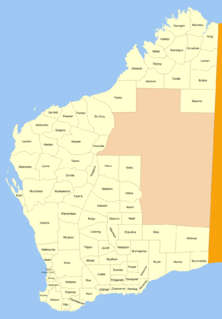
Ninghan Land District is a land district (cadastral division) of Western Australia partly within the Northwest and Southwest divisions.

The lands administrative divisions of Western Australia refer to subdivisions of the state of Western Australia for cadastral purposes, most of which have been in place since the 19th century. The state is divided up for this purpose into five land divisions, which in turn are subdivided into land districts, which correspond to counties in other Australian states. These districts are then subdivided further into numbered locations, as well as gazetted townsites. Together, they form part of the lands administrative divisions of Australia.

Western Australia State in Australia

Western Australia is a state occupying the entire western third of Australia. It is bounded by the Indian Ocean to the north and west, and the Southern Ocean to the south, the Northern Territory to the north-east, and South Australia to the south-east. Western Australia is Australia's largest state, with a total land area of 2,529,875 square kilometres, and the second-largest country subdivision in the world, surpassed only by Russia's Sakha Republic. The state has about 2.6 million inhabitants – around 11 percent of the national total – of whom the vast majority live in the south-west corner, 79 per cent of the population living in the Perth area, leaving the remainder of the state sparsely populated.
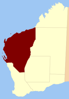
North-West Land Division

The North-West Land Division is one of five Land Divisions of Western Australia, part of the Cadastral divisions of Western Australia. It includes Carnarvon, Exmouth and Port Hedland. It is located in the Gascoyne region, the western Pilbara region, and part of the Mid West


Coordinates: 30°10′S117°35′E / 30.167°S 117.583°E / -30.167; 117.583

Geographic coordinate system Coordinate system

A geographic coordinate system is a coordinate system that enables every location on Earth to be specified by a set of numbers, letters or symbols. The coordinates are often chosen such that one of the numbers represents a vertical position and two or three of the numbers represent a horizontal position; alternatively, a geographic position may be expressed in a combined three-dimensional Cartesian vector. A common choice of coordinates is latitude, longitude and elevation. To specify a location on a plane requires a map projection.


Related Research Articles

Arctic Archipelago Canadian archipelago

The Arctic Archipelago, also known as the Canadian Arctic Archipelago, groups together all islands lying to the north of the Canadian continental mainland excluding Greenland.

Herford is a Kreis (district) in the northeastern part of North Rhine-Westphalia, Germany. Neighboring districts are Minden-Lübbecke, Lippe, the urban district of Bielefeld, and the districts Gütersloh and Osnabrück.

Luxembourg District one of three districts of the Grand Duchy of Luxembourg

The District of Luxembourg was one of three districts of the Grand Duchy of Luxembourg. It contained four cantons, divided into 44 communes:

  1. Capellen
  2. Esch-sur-Alzette
  3. Luxembourg
  4. Mersch
Snuol District District in Kratié, Cambodia

Snuol is a district located in Kratié Province, in Cambodia.

The Electoral district of Midlands was an electoral district of the Victorian Legislative Assembly.

Balia, Bangladesh may refer to the following locations in Bangladesh:

Śnieżki Village in Podlaskie, Poland

Śnieżki is a village in the administrative district of Gmina Boćki, within Bielsk County, Podlaskie Voivodeship, in north-eastern Poland. It lies approximately 12 kilometres (7 mi) south-east of Boćki, 21 km (13 mi) south of Bielsk Podlaski, and 60 km (37 mi) south of the regional capital Białystok.

Koniewo, Warmian-Masurian Voivodeship Village in Warmian-Masurian, Poland

Koniewo is a village in the administrative district of Gmina Lidzbark Warmiński, within Lidzbark County, Warmian-Masurian Voivodeship, in northern Poland. It lies approximately 6 kilometres (4 mi) north of Lidzbark Warmiński and 43 km (27 mi) north of the regional capital Olsztyn.

Westliche Petermann Range is one of the Petermann Ranges, extending north-south for 16 nautical miles (30 km) from Mount Hansen to Aurdalen Valley, in the Wohlthat Mountains, Queen Maud Land. Discovered and plotted from air photos by German Antarctic Expedition, 1938–39, and so named by them for its western position in the northern part of the Petermann Ranges.

Balladonia Land District Cadastral in Western Australia

Balladonia Land District is a land district of Western Australia mostly within the Eucla Land Division. It spans roughly 31°50'S - 32°40'S in latitude and 123°10'E - 124°00'E in longitude.

Nabberu Land District Cadastral in Western Australia

Nabberu Land District is a land district of Western Australia, located within the Eastern Land Division.

Kojonup Land District Cadastral in Western Australia

Kojonup Land District is a land district of Western Australia, located within the South West Division.

Melbourne Land District Cadastral in Western Australia

Melbourne Land District is a land district of Western Australia, located within the South West Division.

Windell Land District Cadastral in Western Australia

Windell Land District is a land district of Western Australia and a subdivision of the North-West Land Division. It contains Newman, Paraburdoo and the former town of Wittenoom.

Nookawarra Land District Cadastral in Western Australia

Nookawarra Land District is a land district of Western Australia, located within the North-West Land Division.

Esperance Land District Cadastral in Western Australia

Esperance Land District is a land district of Western Australia, located within the Eucla Land Division on the state's south coast. It spans roughly 33°15'S - 34°00'S in latitude and 121°00'E - 122°20'E in longitude.

Erivilla Land District Cadastral in Western Australia

Erivilla Land District is a land district of Western Australia, located within the North-West Land Division.

Nuyts Land District Cadastral in Western Australia

Nuyts Land District is a land district of Western Australia, located within the Eastern and Eucla land divisions on the Nullarbor Plain. It spans roughly 31°00'S - 32°50'S in latitude and 124°00'E - 125°30'E in longitude.

Tugaila Land District Cadastral in Western Australia

Tugaila Land District is a land district of Western Australia, located within the Eastern Land Division in the Gibson Desert. It spans roughly 24°00'S - 26°50'S in latitude and 123°20'E - 125°50'E in longitude.