Teano Land District

Last updated

Teano
Western Australia
Western Australia land districts.png

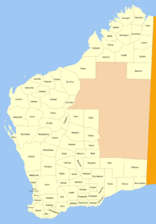
Teano Land District is a land district (cadastral division) of Western Australia, located within the North-West Land Division.

The lands administrative divisions of Western Australia refer to subdivisions of the state of Western Australia for cadastral purposes, most of which have been in place since the 19th century. The state is divided up for this purpose into five land divisions, which in turn are subdivided into land districts, which correspond to counties in other Australian states. These districts are then subdivided further into numbered locations, as well as gazetted townsites. Together, they form part of the lands administrative divisions of Australia.

Western Australia State in Australia

Western Australia is a state occupying the entire western third of Australia. It is bounded by the Indian Ocean to the north and west, and the Southern Ocean to the south, the Northern Territory to the north-east, and South Australia to the south-east. Western Australia is Australia's largest state, with a total land area of 2,529,875 square kilometres, and the second-largest country subdivision in the world, surpassed only by Russia's Sakha Republic. The state has about 2.6 million inhabitants – around 11 percent of the national total – of whom the vast majority live in the south-west corner, 79 per cent of the population living in the Perth area, leaving the remainder of the state sparsely populated.
North-West Land Division

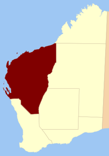
The North-West Land Division is one of five Land Divisions of Western Australia, part of the Cadastral divisions of Western Australia. It includes Carnarvon, Exmouth and Port Hedland. It is located in the Gascoyne region, the western Pilbara region, and part of the Mid West


Coordinates: 24°25′S118°50′E / 24.417°S 118.833°E / -24.417; 118.833

Geographic coordinate system Coordinate system

A geographic coordinate system is a coordinate system that enables every location on Earth to be specified by a set of numbers, letters or symbols. The coordinates are often chosen such that one of the numbers represents a vertical position and two or three of the numbers represent a horizontal position; alternatively, a geographic position may be expressed in a combined three-dimensional Cartesian vector. A common choice of coordinates is latitude, longitude and elevation. To specify a location on a plane requires a map projection.


Related Research Articles

Arctic Archipelago Canadian archipelago

The Arctic Archipelago, also known as the Canadian Arctic Archipelago, groups together all islands lying to the north of the Canadian continental mainland excluding Greenland.

Usarp Mountains

The Usarp Mountains is a major Antarctic mountain range, lying westward of the Rennick Glacier and trending N-S for about 190 kilometres (118 mi). The feature is bounded to the north by Pryor Glacier and the Wilson Hills. Its important constituent parts include Welcome Mountain, Mount Van der Hoeven, Mount Weihaupt, Mount Stuart, Mount Lorius, Smith Bench, Mount Roberts, Pomerantz Tableland, Daniels Range, Emlen Peaks, Helliwell Hills and Morozumi Range.

Cau Ngang is a district (huyện) of Trà Vinh Province in the Mekong Delta region of Vietnam.

Nowe Wymyƛle Village in Masovian, Poland

Nowe Wymyśle is a village in the administrative district of Gmina Gąbin, within Płock County, Masovian Voivodeship, in east-central Poland. It lies approximately 8 kilometres (5 mi) east of Gąbin, 18 km (11 mi) south-east of Płock, and 83 km (52 mi) west of Warsaw.

Ruchocinek Village in Greater Poland, Poland

Ruchocinek is a village in the administrative district of Gmina Witkowo, within Gniezno County, Greater Poland Voivodeship, in west-central Poland. It lies approximately 5 kilometres (3 mi) south-east of Witkowo, 21 km (13 mi) south-east of Gniezno, and 63 km (39 mi) east of the regional capital Poznań.

Posadowsky Glacier (Antarctica)

Posadowsky Glacier is a glacier about 9 nautical miles long, flowing north to Posadowsky Bay immediately east of Gaussberg. Posadowsky Bay is an open embayment, located just east of the West Ice Shelf and fronting on the Davis Sea in Kaiser Wilhelm II Land. Kaiser Wilhelm II Land is the part of East Antarctica lying between Cape Penck, at 87°43'E, and Cape Filchner, at 91°54'E, and is claimed by Australia as part of the Australian Antarctic Territory. Other notable geographic features in this area include Drygalski Island, located 45 mi NNE of Cape Filchner in the Davis Sea, and Mirny Station, a Russian scientific research station.

Willey Glacier is a heavily crevassed glacier north of Creswick Peaks in Palmer Land, flowing west from Creswick Gap into George VI Sound. Named by United Kingdom Antarctic Place-Names Committee (UK-APC) for Lawrence E. Willey, British Antarctic Survey (BAS) geologist at Fossil Bluff and Stonington Island stations, 1966–69 and 1973, and awarded the Polar Medal for services to Antarctic Survey in 1976.

Yilgarn Land District Cadastral in Western Australia

Yilgarn Land District is a land district of Western Australia, located within the Eastern Land Division.

Kaluwiri Land District Cadastral in Western Australia

Kaluwiri Land District is a land district of Western Australia, located within the Eastern Land Division.

Jilbadji Land District Cadastral in Western Australia

Jilbadji Land District is a land district of Western Australia, located within the Eastern Land Division.

Jaurdi Land District Cadastral in Western Australia

Jaurdi Land District is a land district of Western Australia, located within the Eastern Land Division.

Kent Land District, Western Australia Cadastral in Western Australia

Kent Land District is a land district of Western Australia, located within the South West Division.

Williams Land District Cadastral in Western Australia

Williams Land District is a land district of Western Australia, located within the South West Division.

Lyons Land District Cadastral in Western Australia

Lyons Land District is a land district of Western Australia, located within the North-West Land Division.

Kyarra Land District Cadastral in Western Australia

Kyarra Land District is a land district of Western Australia, located within the North-West Land Division.

Gascoyne Land District Cadastral in Western Australia

Gascoyne Land District is a land district of Western Australia, located within the North-West Land Division.

Forrest Land District Cadastral in Western Australia

Forrest Land District is a land district of Western Australia and a subdivision of the North-West Land Division. It contains the towns of Port Hedland and South Hedland.

Hann Land District Cadastral in Western Australia

Hann Land District is a land district of Western Australia, located within the Eastern Land Division of the state. It spans roughly 24°00'S - 25°40'S in latitude and 120°00'E - 121°40'E in longitude, east of the rabbit-proof fence. Part of the Canning Stock Route passes through the south-east of the district. It is named in honour of explorer Frank Hann.

Tugaila Land District Cadastral in Western Australia

Tugaila Land District is a land district of Western Australia, located within the Eastern Land Division in the Gibson Desert. It spans roughly 24°00'S - 26°50'S in latitude and 123°20'E - 125°50'E in longitude.

Milyuga Land District Cadastral in Western Australia

Milyuga Land District is a land district of Western Australia, located within the Eastern Land Division in the Gibson Desert. It spans roughly 24°00'S - 26°50'S in latitude and 125°50'E - 129°00'E in longitude, and includes the town of Warburton and the Giles Weather Station.