Peawah Land District

Last updated

Peawah
Western Australia
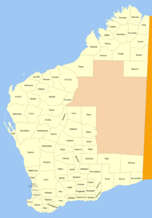
Western Australia land districts.png

Peawah Land District is a land district (cadastral division) of Western Australia, located within the North-West Land Division.

The lands administrative divisions of Western Australia refer to subdivisions of the state of Western Australia for cadastral purposes, most of which have been in place since the 19th century. The state is divided up for this purpose into five land divisions, which in turn are subdivided into land districts, which correspond to counties in other Australian states. These districts are then subdivided further into numbered locations, as well as gazetted townsites. Together, they form part of the lands administrative divisions of Australia.

Western Australia State in Australia

Western Australia is a state occupying the entire western third of Australia. It is bounded by the Indian Ocean to the north and west, and the Southern Ocean to the south, the Northern Territory to the north-east, and South Australia to the south-east. Western Australia is Australia's largest state, with a total land area of 2,529,875 square kilometres, and the second-largest country subdivision in the world, surpassed only by Russia's Sakha Republic. The state has about 2.6 million inhabitants – around 11 percent of the national total – of whom the vast majority live in the south-west corner, 79 per cent of the population living in the Perth area, leaving the remainder of the state sparsely populated.
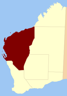
North-West Land Division

The North-West Land Division is one of five Land Divisions of Western Australia, part of the Cadastral divisions of Western Australia. It includes Carnarvon, Exmouth and Port Hedland. It is located in the Gascoyne region, the western Pilbara region, and part of the Mid West


Coordinates: 21°20′S117°40′E / 21.333°S 117.667°E / -21.333; 117.667

Geographic coordinate system Coordinate system

A geographic coordinate system is a coordinate system that enables every location on Earth to be specified by a set of numbers, letters or symbols. The coordinates are often chosen such that one of the numbers represents a vertical position and two or three of the numbers represent a horizontal position; alternatively, a geographic position may be expressed in a combined three-dimensional Cartesian vector. A common choice of coordinates is latitude, longitude and elevation. To specify a location on a plane requires a map projection.


Related Research Articles

Arctic Archipelago Canadian archipelago

The Arctic Archipelago, also known as the Canadian Arctic Archipelago, groups together all islands lying to the north of the Canadian continental mainland excluding Greenland.

Sagarmatha Zone Zone in Nepal

Sagarmāthā was one of the fourteen zones of Nepal until the restructuring of zones into provinces. Sagarmāthā is a Nepali word derived from सगर (sagar) meaning "sky" and माथा (māthā) meaning "head".

Division No. 21, Manitoba census division of Canada

Division No. 21, also informally known as Flin Flon-Northwest, is a census division in the Canadian province of Manitoba. Census maps show that the division also includes the northernmost portion of Lake Winnipeg as part of its southeasternmost section.

Tuần Giáo District District in Northwest, Vietnam

Tuần Giáo is a rural district of Điện Biên Province in the Northwest region of Vietnam. As of 2003, the district had a population of 104,185. The district covers an area of 1,583 km². The district capital lies at Tuần Giáo.

Albrecht Penck Glacier glacier in Antarctica

Albrecht Penck Glacier is a glacier between the Fry Glacier and the Evans Piedmont Glacier, draining northeast toward Tripp Bay on the coast of Victoria Land, Antarctica. It was first charted by the British Antarctic Expedition (1907–09) which named this feature for Albrecht Penck, the Director of the Institute of Oceanography and of the Geographical Institute in Berlin.

Sugajno Village in Kuyavian-Pomeranian, Poland

Sugajno is a village in the administrative district of Gmina Brzozie, within Brodnica County, Kuyavian-Pomeranian Voivodeship, in north-central Poland. It lies 21 kilometres (13 mi) north-east of Brodnica and 78 km (48 mi) north-east of Toruń.

Charubin Village in Podlaskie, Poland

Charubin is a village in the administrative district of Gmina Turośl, within Kolno County, Podlaskie Voivodeship, in north-eastern Poland. It lies approximately 20 kilometres (12 mi) south-west of Kolno and 103 km (64 mi) west of the regional capital Białystok.

Potrzanowo Village in Greater Poland, Poland

Potrzanowo is a village in the administrative district of Gmina Skoki, within Wągrowiec County, Greater Poland Voivodeship, in west-central Poland. It lies approximately 3 kilometres (2 mi) west of Skoki, 16 km (10 mi) south of Wągrowiec, and 33 km (21 mi) north-east of the regional capital Poznań.

Stare Kiełbonki Village in Warmian-Masurian, Poland

Stare Kiełbonki is a village in the administrative district of Gmina Piecki, within Mrągowo County, Warmian-Masurian Voivodeship, in northern Poland. It lies approximately 10 kilometres (6 mi) south of Piecki, 23 km (14 mi) south of Mrągowo, and 57 km (35 mi) east of the regional capital Olsztyn.

Strauss Glacier is a glacier, 40 nautical miles (70 km) long, flowing between the Ickes Mountains and Coulter Heights to enter the sea at the east side of Land Bay, Marie Byrd Land. Mapped by United States Geological Survey (USGS) from surveys and U.S. Navy air photos, 1959-65. The naming was proposed to Advisory Committee on Antarctic Names (US-ACAN) by Admiral Richard E. Byrd. Named for Lewis Strauss, Chairman of the Atomic Energy Commission, 1953–58, longtime friend and advisor to Admiral Byrd who recommended that the Antarctic be used to demonstrate peaceful employment of atomic energy.

Dampier Land District Cadastral in Western Australia

Dampier Land District is a land district of Western Australia, located within the Kimberley Division of the state.

Hay Land District Cadastral in Western Australia

Not to be confused with the land district of the same name in New South Wales

Kojonup Land District Cadastral in Western Australia

Kojonup Land District is a land district of Western Australia, located within the South West Division.

Plantagenet Land District Cadastral in Western Australia

Plantagenet Land District is a land district of Western Australia, located within the South West Division.

De Grey Land District Cadastral in Western Australia

De Grey Land District is a land district of Western Australia and a subdivision of the North-West Land Division. It includes the Pilbara towns of Marble Bar and Nullagine and the former town of Goldsworthy.

De Witt Land District Cadastral in Western Australia

De Witt District is a land district of Western Australia, located within the North-West Land Division.

Edel Land District Cadastral in Western Australia

Edel Land District is a land district of Western Australia, located within the North-West Land Division.

Murchison Land District Cadastral in Western Australia

Murchison Land District is a land district of Western Australia, located within the North-West Land Division.

Gregory Land District Cadastral in Western Australia

Gregory Land District is a land district of Western Australia, located within the North-West Land Division.

Hardey Land District Cadastral in Western Australia

Hardey Land District is a land district of Western Australia, located within the North-West Land Division.