Cockburn Sound Land District

Last updated

Cockburn Sound
Western Australia
Western Australia land districts.png

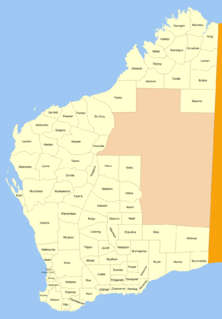
Cockburn Sound Land District is a land district (cadastral division) of Western Australia, located within the South West Division.

The lands administrative divisions of Western Australia refer to subdivisions of the state of Western Australia for cadastral purposes, most of which have been in place since the 19th century. The state is divided up for this purpose into five land divisions, which in turn are subdivided into land districts, which correspond to counties in other Australian states. These districts are then subdivided further into numbered locations, as well as gazetted townsites. Together, they form part of the lands administrative divisions of Australia.

Western Australia State in Australia

Western Australia is a state occupying the entire western third of Australia. It is bounded by the Indian Ocean to the north and west, and the Southern Ocean to the south, the Northern Territory to the north-east, and South Australia to the south-east. Western Australia is Australia's largest state, with a total land area of 2,529,875 square kilometres, and the second-largest country subdivision in the world, surpassed only by Russia's Sakha Republic. The state has about 2.6 million inhabitants – around 11 percent of the national total – of whom the vast majority live in the south-west corner, 79 per cent of the population living in the Perth area, leaving the remainder of the state sparsely populated.


Coordinates: 32°20′S115°50′E / 32.333°S 115.833°E / -32.333; 115.833

Geographic coordinate system Coordinate system

A geographic coordinate system is a coordinate system that enables every location on Earth to be specified by a set of numbers, letters or symbols. The coordinates are often chosen such that one of the numbers represents a vertical position and two or three of the numbers represent a horizontal position; alternatively, a geographic position may be expressed in a combined three-dimensional Cartesian vector. A common choice of coordinates is latitude, longitude and elevation. To specify a location on a plane requires a map projection.


Related Research Articles

Geography of France

The geography of France consists of a terrain that is mostly flat plains or gently rolling hills in the north and west and mountainous in the south and the east.

Northern District (Israel) District of Israel

The Northern District is one of Israel's six administrative districts. The Northern District has a land area of 4,478 km², which increases to 4,638 km² when both land and water are included. The district capital is Nof HaGalil and the largest city is Nazareth.

Caia District District in Sofala, Mozambique

Caia District is a district of Sofala Province in Mozambique. The principal town is Caia. The district is located in the north of the province, and borders with Chemba District in the north, Marromeu District in the southeast, Cheringoma District in the south, and with Maringué District in the west. In the east, the district is bounded by the Indian Ocean. The area of the district is 3,542 square kilometres (1,368 sq mi). It has a population of 115,455 as of 2007.

Pilipki Village in Podlaskie, Poland

Pilipki is a village in the administrative district of Gmina Bielsk Podlaski, within Bielsk County, Podlaskie Voivodeship, in north-eastern Poland. It lies approximately 12 kilometres (7 mi) north-east of Bielsk Podlaski and 34 km (21 mi) south of the regional capital Białystok.

County of Churchill, Queensland Cadastral in Queensland, Australia

The County of Churchill is a county in Queensland, Australia. Like all counties in Queensland, it is a non-functional administrative unit, that is used mainly for the purpose of registering land titles. The county lies between 152°E and 153°E longitude, and is centred on the West Moreton region, extending east to the suburbs of Ipswich. The county was named for Lord Randolph Churchill, who was born in 1849, by the Surveyor-General of New South Wales the following year; the area was officially named and bounded by the Governor in Council on 7 March 1901 under the Land Act 1897.

Bachórzec Village in Subcarpathian, Poland

Bachórzec is a village in the administrative district of Gmina Dubiecko, within Przemyśl County, Subcarpathian Voivodeship, in south-eastern Poland. It lies approximately 5 kilometres (3 mi) west of Dubiecko, 32 km (20 mi) west of Przemyśl, and 33 km (21 mi) south-east of the regional capital Rzeszów.

Yushui is the only district of and one of two divisions of the prefecture-level city of Xinyu, Jiangxi province, China, the other being Fenyi County. It has a land area of 1,776 km2 (686 sq mi), and a population of 839,500 as of 2010. The Zip code is 338025.

Chililabombwe District District in Copperbelt Province, Zambia

Chililabombwe District is a district of Zambia, located in Copperbelt Province. The capital lies at Chililabombwe. As of the 2000 Zambian Census, the district had a population of 67,533 people.

Sussex County, Western Australia county of Western Australia

Sussex County was one of the 26 counties of Western Australia that were designated in 1829 as cadastral divisions. Lieutenant-Governor James Stirling named the county in honour of Prince Augustus Frederick, Duke of Sussex, the sixth son of George III.

Ashburton Land District Cadastral in Western Australia

Ashburton Land District is a land district of Western Australia, located within the North-West Land Division.

Malcolm Land District Cadastral in Western Australia

Malcolm Land District is a land district of Western Australia, located within the Eastern Land Division in the northern Goldfields region of the state.

Canning Land District Cadastral in Western Australia

Canning Land District is a land district of Western Australia, located within the South West Division in the eastern and south-eastern suburbs of metropolitan Perth.

Kent Land District, Western Australia Cadastral in Western Australia

Kent Land District is a land district of Western Australia, located within the South West Division.

Plantagenet Land District Cadastral in Western Australia

Plantagenet Land District is a land district of Western Australia, located within the South West Division.

Williams Land District Cadastral in Western Australia

Williams Land District is a land district of Western Australia, located within the South West Division.

Kyarra Land District Cadastral in Western Australia

Kyarra Land District is a land district of Western Australia, located within the North-West Land Division.

Gascoyne Land District Cadastral in Western Australia

Gascoyne Land District is a land district of Western Australia, located within the North-West Land Division.

Hardey Land District Cadastral in Western Australia

Hardey Land District is a land district of Western Australia, located within the North-West Land Division.

Dundas Land District Cadastral in Western Australia

Dundas Land District is a land district of Western Australia within the Eucla Land Division. It spans roughly 31°40'S - 32°40'S in latitude and 121°00'E - 122°15'E in longitude.

Hann Land District Cadastral in Western Australia

Hann Land District is a land district of Western Australia, located within the Eastern Land Division of the state. It spans roughly 24°00'S - 25°40'S in latitude and 120°00'E - 121°40'E in longitude, east of the rabbit-proof fence. Part of the Canning Stock Route passes through the south-east of the district. It is named in honour of explorer Frank Hann.