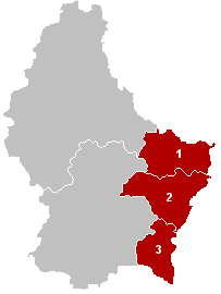
The District of Grevenmacher was one of three districts of Luxembourg. It contained three cantons divided into 25 communes:
- Echternach
- Grevenmacher
- Remich
Rayner Glacier is a prominent glacier, 19 kilometres (10 nmi) wide, flowing north to the coast of Enderby Land just west of Condon Hills. It was sighted in October 1956 by Squadron Leader D. Leckie during a flight in an ANARE Beaver aircraft, and named by ANCA for J.M. Rayner, Director of the Bureau of Mineral Resources in the Australian Department of National Development.

Dubicze Tofiłowce is a village in the administrative district of Gmina Dubicze Cerkiewne, within Hajnówka County, Podlaskie Voivodeship, in north-eastern Poland, close to the border with Belarus. It lies approximately 3 kilometres (2 mi) north-west of Dubicze Cerkiewne, 13 km (8 mi) south-west of Hajnówka, and 53 km (33 mi) south of the regional capital Białystok.
Harasimowicze is a village in the administrative district of Gmina Dąbrowa Białostocka, within Sokółka County, Podlaskie Voivodeship, in north-eastern Poland. It lies approximately 5 kilometres (3 mi) north-east of Dąbrowa Białostocka, 31 km (19 mi) north of Sokółka, and 64 km (40 mi) north of the regional capital Białystok.
Tymianki-Bucie is a village in the administrative district of Gmina Boguty-Pianki, within Ostrów Mazowiecka County, Masovian Voivodeship, in east-central Poland. It lies approximately 8 kilometres (5 mi) south of Boguty-Pianki, 38 km (24 mi) south-east of Ostrów Mazowiecka, and 109 km (68 mi) north-east of Warsaw.
Tymianki-Skóry is a village in the administrative district of Gmina Boguty-Pianki, within Ostrów Mazowiecka County, Masovian Voivodeship, in east-central Poland. It lies approximately 8 kilometres (5 mi) south of Boguty-Pianki, 38 km (24 mi) south-east of Ostrów Mazowiecka, and 109 km (68 mi) north-east of Warsaw.
Ochudno is a village in the administrative district of Gmina Rząśnik, within Wyszków County, Masovian Voivodeship, in east-central Poland. It lies approximately 6 kilometres (4 mi) south-east of Rząśnik, 9 km (6 mi) north of Wyszków, and 58 km (36 mi) north-east of Warsaw.
Ułanowo is a village in the administrative district of Gmina Kłecko, within Gniezno County, Greater Poland Voivodeship, in west-central Poland. It lies approximately 4 kilometres (2 mi) north of Kłecko, 20 km (12 mi) north-west of Gniezno, and 45 km (28 mi) north-east of the regional capital Poznań.

Dampier Land District is a land district of Western Australia, located within the Kimberley Division of the state.
Bulga Land District is a land district of Western Australia, located within the Eastern Land Division.
Jilbadji Land District is a land district of Western Australia, located within the Eastern Land Division.
Not to be confused with the land district of the same name in New South Wales
Edel Land District is a land district of Western Australia, located within the North-West Land Division.
Thadoona Land District is a land district of Western Australia and a subdivision of the North-West Land Division located in the Mid West region of the state.
Murchison Land District is a land district of Western Australia, located within the North-West Land Division.
Dempster Land District is a land district of Western Australia, located within the Eucla Land Division.
Mardarbilla Land District is a land district of Western Australia located within the Eucla Land Division on the western edge of the Great Australian Bight. It spans roughly 32°40'S - 33°55'S in latitude and 123°30'E - 124°00'E in longitude. Much of the district is within the Cape Arid National Park, and it contains the town of Israelite Bay.
Nuyts Land District is a land district of Western Australia, located within the Eastern and Eucla land divisions on the Nullarbor Plain. It spans roughly 31°00'S - 32°50'S in latitude and 124°00'E - 125°30'E in longitude.
Oldfield Land District is a land district of Western Australia partly within the Eucla and South-West divisions on the state's south coast. It spans roughly 33°15'S - 34°00'S in latitude and 119°45'E - 121°10'E in longitude.
Tugaila Land District is a land district of Western Australia, located within the Eastern Land Division in the Gibson Desert. It spans roughly 24°00'S - 26°50'S in latitude and 123°20'E - 125°50'E in longitude.
This page is based on this
Wikipedia article Text is available under the
CC BY-SA 4.0 license; additional terms may apply.
Images, videos and audio are available under their respective licenses.


