Kohat District is a district in Kohat Division of Khyber Pakhtunkhwa province in Pakistan, Kohat city is the capital of the district.

Lahore Division is an administrative division of Punjab Province, Pakistan. Before 2000 it comprised four Districts - Kasur, Lahore, Nankana Sahib District and Sheikhupura. Under the reforms of 2000, this tier of government was abolished, but in 2000 divisions were restored. However, the restored Lahore Division has only comprised Kasur and Lahore Districts; a new division, Sheikhupura Division was created to comprise Nankana Sahib and Sheikhupura Districts.

Ruchocice is a village in the administrative district of Gmina Rakoniewice, within Grodzisk Wielkopolski County, Greater Poland Voivodeship, in west-central Poland. It lies approximately 6 kilometres (4 mi) north-east of Rakoniewice, 8 km (5 mi) south of Grodzisk Wielkopolski, and 48 km (30 mi) south-west of the regional capital Poznań.
A Lưới is a rural district of Thừa Thiên-Huế Province in the North Central Coast region of Vietnam. It is located west in the highly mountainous area of A Shau Valley bordering Laos. The population includes many Bru, Hoa and Tà Ôi people. As of 2003 the district had a population of 38,616. The district covers an area of 1,229 km² and its capital lies at A Lưới, a former French airfield, later used by the Americans in Operation Delaware and then by the North Vietnamese for courier flights.

Augustowo is a village in the administrative district of Gmina Wielichowo, within Grodzisk Wielkopolski County, Greater Poland Voivodeship, in west-central Poland. It lies approximately 6 kilometres (4 mi) north of Wielichowo, 8 km (5 mi) south of Grodzisk Wielkopolski, and 48 km (30 mi) south-west of the regional capital Poznań.

Lukulu District is a district of Zambia, located in Western Province. The capital lies at Lukulu. As of the 2000 Zambian Census, the district had a population of 68,375 people.

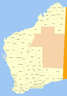
Bulara Land District is a land district of Western Australia, located within the Kimberley Division of the state.

Marndoc Land District is one of the land districts of Western Australia, located within the Kimberley Division of the state.

Luman Land District is a land district of Western Australia, located within the Kimberley Division of the state.

Yelina Land District is a land district of Western Australia, located within the Eastern Land Division.

Ngalbain Land District is a land district of Western Australia, located within the Eastern Land Division.

Cockburn Sound Land District is a land district of Western Australia, located within the South West Division.

Plantagenet Land District is a land district of Western Australia, located within the South West Division.

De Witt District is a land district of Western Australia, located within the North-West Land Division.

Peawah Land District is a land district of Western Australia, located within the North-West Land Division.

Kyarra Land District is a land district of Western Australia, located within the North-West Land Division.

Gregory Land District is a land district of Western Australia, located within the North-West Land Division.

Hardey Land District is a land district of Western Australia, located within the North-West Land Division.

Giles Land District is a land district of Western Australia, located within the Eastern and Eucla land divisions on the Nullarbor Plain. It spans roughly 29°00'S - 31°00'S in latitude and 123°30'E - 126°30'E in longitude.
The Electoral district of Castlemaine and Kyneton was an electoral district of the Victorian Legislative Assembly (Australia).
This page is based on this
Wikipedia article Text is available under the
CC BY-SA 4.0 license; additional terms may apply.
Images, videos and audio are available under their respective licenses.


