Sussex Land District

Last updated

Sussex
Western Australia
Sussex land district WA.png
Location in Western Australia
Lands administrative divisions around Sussex:
Indian Ocean Indian Ocean Wellington
Indian Ocean Sussex Nelson
Indian Ocean Flinders Bay Nelson

Sussex Land District is a land district (cadastral division) of Western Australia, located within the South-West Land Division on the state's west coast. It covers the south-western corner of the state and includes the townsites of Busselton, Margaret River and Augusta as well as Cape Naturaliste and Cape Leeuwin. [1]

Contents

History

The system of land districts came together in an ad-hoc fashion, and the Sussex district started to be subdivided in 1840 well before any thought was given to formally defining its boundaries. [2] The definition later used by the Lands and Surveys department came from an 1862 gazettal which read as follows: [3]

Bounded on the North by an East line from the sea-coast to Capel River through the North end of Wonnerup Inlet, then by said river upwards to location 171 (exclusive), then by a South-easterly line to junction of Padbury Brook with the River Blackwood; on the West and South by the sea-coast; and on the East by the Blackwood downwards to its junction with a South line through Black Point, thence by that line to the sea-coast.

Towns and areas

Towns

The Sussex district contains the following current or former townsites: [4]

TownsiteCoordinatesGazettedNotes
Augusta 34°18′43″S115°09′32″E / 34.312°S 115.159°E / -34.312; 115.159 (Augusta) 1830
Broadwater 33°39′43″S115°16′34″E / 33.662°S 115.276°E / -33.662; 115.276 (Broadwater Suburban) 1897
Busselton 33°38′53″S115°20′46″E / 33.648°S 115.346°E / -33.648; 115.346 (Busselton) 1835
Carbunup River 33°41′56″S115°11′20″E / 33.699°S 115.189°E / -33.699; 115.189 (Carbunup River) 1926
Cowaramup 33°51′07″S115°05′42″E / 33.852°S 115.095°E / -33.852; 115.095 (Cowaramup) 1925
Dunsborough 33°36′50″S115°06′18″E / 33.614°S 115.105°E / -33.614; 115.105 (Dunsborough) 1879
Forest Grove 34°04′19″S115°05′53″E / 34.072°S 115.098°E / -34.072; 115.098 (Forest Grove) 1925Cancelled in 1970
Gracetown 33°52′05″S114°59′13″E / 33.868°S 114.987°E / -33.868; 114.987 (Gracetown) 1963
Jarrahwood 33°47′49″S115°39′58″E / 33.797°S 115.666°E / -33.797; 115.666 (Jarrahwood) 1932
Margaret River 33°57′18″S115°04′30″E / 33.955°S 115.075°E / -33.955; 115.075 (Margaret River) 1913
Mowen 33°56′17″S115°11′46″E / 33.938°S 115.196°E / -33.938; 115.196 (Mowen) 1925
Prevelly 33°58′52″S114°59′31″E / 33.981°S 114.992°E / -33.981; 114.992 (Prevelly) 1978
Quigup 33°57′29″S115°42′07″E / 33.958°S 115.702°E / -33.958; 115.702 (Quigup) 1911
Quindalup 33°37′44″S115°07′44″E / 33.629°S 115.129°E / -33.629; 115.129 (Quindalup) 1899
Ruabon 33°39′14″S115°29′28″E / 33.654°S 115.491°E / -33.654; 115.491 (Ruabon) 1925"Abba River" until 1928
Vasse 33°41′02″S115°15′50″E / 33.684°S 115.264°E / -33.684; 115.264 (Vasse) 1907
Witchcliffe 34°01′26″S115°05′56″E / 34.024°S 115.099°E / -34.024; 115.099 (Witchcliffe) 1926
Wonnerup 33°37′26″S115°24′58″E / 33.624°S 115.416°E / -33.624; 115.416 (Wonnerup) 1856
Yallingup 33°38′24″S115°01′44″E / 33.640°S 115.029°E / -33.640; 115.029 (Yallingup) 1911*Not formally gazetted

Agricultural areas

Under the Land Act 1898, the Agricultural Lands Purchase Act 1896, and preceding regulations, it was open to the Governor to declare agricultural areas on crown land or repurchased estates on private land, to which special provisions applied for both alienation and improvement. Many of these estates came into being shortly after World War I for the purposes of soldier resettlement.

NameCoordinatesGazettedNotes
Anniebrook Estate 33°39′14″S115°10′37″E / 33.654°S 115.177°E / -33.654; 115.177 (Anniebrook Estate) 1930West of Busselton
Locke's Estate 33°39′50″S115°14′10″E / 33.664°S 115.236°E / -33.664; 115.236 (Locke's Estate) 1921West of Busselton
Marybrook Estate 33°39′32″S115°12′04″E / 33.659°S 115.201°E / -33.659; 115.201 (Marybrook Estate) 1907West of Busselton
Stirling Estate 33°33′50″S115°28′55″E / 33.564°S 115.482°E / -33.564; 115.482 (Stirling Estate) 1904Near Ruabon

Related Research Articles

<span class="mw-page-title-main">Margaret River, Western Australia</span> Town in Western Australia

Margaret River is a town in the South West of Western Australia, located in the valley of the eponymous Margaret River, 277 kilometres (172 mi) south of Perth, the state capital. Its Local Government Area is the Shire of Augusta-Margaret River.

<span class="mw-page-title-main">Leeuwin-Naturaliste National Park</span> Protected area in Western Australia

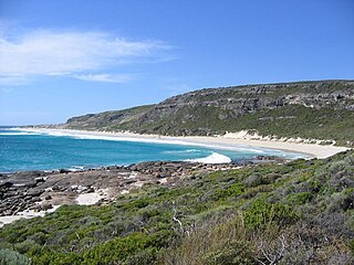
Leeuwin-Naturaliste National Park is a national park in the South West region of Western Australia, 267 km (166 mi) south of Perth. It is named after the two locations at either end of the park which have lighthouses, Cape Leeuwin and Cape Naturaliste. It is located in the Augusta-Margaret River and Busselton council areas, and is claimed to have the highest visiting numbers of any national park in Western Australia. The park received 2.33 million visitors through 2008–2009.

<span class="mw-page-title-main">City of Cockburn</span> Local government area in Western Australia

The City of Cockburn is a local government area in the southern suburbs of the Western Australian capital city of Perth about 8 kilometres (5 mi) south of Fremantle and about 24 kilometres (15 mi) south of Perth's central business district. The City covers an area of 167.5 square kilometres (64.7 sq mi) and had a population of over 104,000 as at the 2016 Census.

<span class="mw-page-title-main">Regions of Western Australia</span> Administrative regions of Western Australia

Western Australia (WA) is divided into regions according to a number of systems.

<span class="mw-page-title-main">Dalwallinu, Western Australia</span> Town in Western Australia

Dalwallinu, colloquially called Dally, is a town in the Wheatbelt region of Western Australia, located 248 km from Perth via the Great Northern Highway. Agriculture and supporting industries are the town's primary economic activities. The town is the first town on the Wildflower Way, a tourist route that stretches north to Mullewa. The town has an elevation of 335 metres (1,099 ft). At the 2016 census, Dalwallinu had a population of 699.

<span class="mw-page-title-main">Augusta, Western Australia</span> Town in Western Australia

Augusta is a town on the south-west coast of Western Australia, where the Blackwood River flows into Flinders Bay. It is the nearest town to Cape Leeuwin, on the furthest southwest corner of the Australian continent. In the 2001 census it had a population of 1,091; by 2016 the population of the town was 1,109.

<span class="mw-page-title-main">Boyanup, Western Australia</span> Town in Western Australia

Boyanup is a town on the South Western Highway in the South West agricultural region, 195 km south of Perth and 18 km south-east of Bunbury, Western Australia. The town is located on the Preston River.

<span class="mw-page-title-main">Wonnerup, Western Australia</span> Town in Western Australia

The townsite of Wonnerup is located 219 kilometres (136 mi) south of Perth and 10 kilometres (6 mi) east of Busselton. It was gazetted a townsite in 1856, deriving its name from the nearby Wonnerup Inlet.

<span class="mw-page-title-main">Boyup Brook, Western Australia</span> Town in Western Australia

Boyup Brook is a town in the south-west of Western Australia, 269 kilometres (167 mi) south-southeast of Perth and 31 kilometres (19 mi) northeast of Bridgetown. The town lies on Kaniyang land within the Noongar nation.

St Alouarn Islands are a group of islands and rocks south-east of Cape Leeuwin in Western Australia, approximately 11 km south of Augusta in Flinders Bay.

<span class="mw-page-title-main">Blackwood River</span> River in Western Australia

The Blackwood River is a major river and catchment in the South West of Western Australia.

The lands administrative divisions of Western Australia refer to subdivisions of the state of Western Australia for cadastral purposes, most of which have been in place since the 19th century. The state is divided up for this purpose into five land divisions, which in turn are subdivided into land districts, which correspond to counties in other Australian states. These districts are then subdivided further into numbered locations, as well as gazetted townsites. Together, they form part of the lands administrative divisions of Australia.

<span class="mw-page-title-main">Nelson Land District</span> Cadastral in Western Australia

Nelson Land District is a land district of Western Australia, located within the South West Division on the state's south coast. It covers part of the state's Lower South West region and includes the townsites of Bridgetown, Manjimup, Pemberton, Northcliffe and Nannup as well as Point D'Entrecasteaux and, at its far southeastern corner, Walpole.

<span class="mw-page-title-main">Wellington Land District, Western Australia</span> Cadastral in Western Australia

Wellington Land District is a land district of Western Australia, located within the South-West Land Division on the state's west coast. It spans roughly 32°56'S - 33°40'S in latitude and 115°25'E - 116°50'E in longitude.

<span class="mw-page-title-main">Murray Land District</span> Cadastral in Western Australia

Murray Land District is a land district of Western Australia, located within the South-West Land Division on the state's west coast. It spans roughly 32°25'S - 32°56'S in latitude and 115°25'E - 116°30'E in longitude, and is located on the Indian Ocean coast, taking in the Shires of Murray and Waroona, the eastern part of the Serpentine-Jarrahdale and the western suburbs of Mandurah.

<span class="mw-page-title-main">Neridup Land District</span> Cadastral in Western Australia

Neridup Land District is a land district of Western Australia, located within the Eucla Land Division on the state's south coast. It spans roughly 33°15'S - 34°00'S in latitude and 122°20'E - 123°30'E in longitude.

<span class="mw-page-title-main">Fitzgerald Land District</span> Cadastral in Western Australia

Fitzgerald Land District is a land district of Western Australia, located within the Eucla Land Division inland from Esperance. It spans roughly 32°35'S - 33°15'S in latitude and 121°00'E - 122°15'E in longitude.

<span class="mw-page-title-main">Esperance Land District</span> Cadastral in Western Australia

Esperance Land District is a land district of Western Australia, located within the Eucla Land Division on the state's south coast. It spans roughly 33°15'S - 34°00'S in latitude and 121°00'E - 122°20'E in longitude.

<span class="mw-page-title-main">Oldfield Land District</span> Cadastral in Western Australia

Oldfield Land District is a land district of Western Australia partly within the Eucla and South-West divisions on the state's south coast. It spans roughly 33°15'S - 34°00'S in latitude and 119°45'E - 121°10'E in longitude.

<span class="mw-page-title-main">West Toodyay</span> Locality in Western Australia

West Toodyay was the original location of the town of Toodyay, Western Australia. It is situated in the Toodyay valley, 85 kilometres (53 mi) north east of Perth. The Toodyay valley, discovered by Ensign Robert Dale in 1831, was opened up for settlement in 1836. The original site for the town of Toodyay was determined in 1836 and its boundaries were finalized 1838. The first survey of the town was carried out in 1849. After several serious floods, the decision was made to move the town of Toodyay to higher ground. In 1860, the new town of Newcastle was established 3 miles (4.8 km) further upstream. Newcastle was renamed in 1910 to Toodyay, and the original site became known as West Toodyay.

References

  1. "Index Map of Western Australia", Department of Lands and Surveys, 1949, and definition in gazette.
  2. Surveyor-General. Districts of the colony – Revision of. (169/96), p.28-30. Accessed at State Records Office, Perth.
  3. "Boundaries defining the Wellington and Sussex Residencies". Western Australia Government Gazette. 1 July 1862. p. N/A.
  4. Western Australian Government Gazette, various editions. Accessed at Battye Library, Perth.

33°54′56″S115°05′06″E / 33.91556°S 115.08500°E / -33.91556; 115.08500