Forrest Land District

Last updated

Forrest
Western Australia
Western Australia land districts.png
Region Pilbara
Lands administrative divisions around Forrest:
Indian Ocean
Peawah Forrest De Grey
Windell

Forrest Land District is a land district (cadastral division) of Western Australia and a subdivision of the North-West Land Division. It contains the towns of Port Hedland and South Hedland.

The lands administrative divisions of Western Australia refer to subdivisions of the state of Western Australia for cadastral purposes, most of which have been in place since the 19th century. The state is divided up for this purpose into five land divisions, which in turn are subdivided into land districts, which correspond to counties in other Australian states. These districts are then subdivided further into numbered locations, as well as gazetted townsites. Together, they form part of the lands administrative divisions of Australia.

Western Australia State in Australia

Western Australia is a state occupying the entire western third of Australia. It is bounded by the Indian Ocean to the north and west, and the Southern Ocean to the south, the Northern Territory to the north-east, and South Australia to the south-east. Western Australia is Australia's largest state, with a total land area of 2,529,875 square kilometres, and the second-largest country subdivision in the world, surpassed only by Russia's Sakha Republic. The state has about 2.6 million inhabitants – around 11 percent of the national total – of whom the vast majority live in the south-west corner, 79 per cent of the population living in the Perth area, leaving the remainder of the state sparsely populated.

North-West Land Division

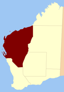
The North-West Land Division is one of five Land Divisions of Western Australia, part of the Cadastral divisions of Western Australia. It includes Carnarvon, Exmouth and Port Hedland. It is located in the Gascoyne region, the western Pilbara region, and part of the Mid West


Coordinates: 21°25′S118°55′E / 21.417°S 118.917°E / -21.417; 118.917

Geographic coordinate system Coordinate system

A geographic coordinate system is a coordinate system that enables every location on Earth to be specified by a set of numbers, letters or symbols. The coordinates are often chosen such that one of the numbers represents a vertical position and two or three of the numbers represent a horizontal position; alternatively, a geographic position may be expressed in a combined three-dimensional Cartesian vector. A common choice of coordinates is latitude, longitude and elevation. To specify a location on a plane requires a map projection.


Related Research Articles

Town of Port Hedland Local government area in Western Australia

The Town of Port Hedland is a local government area in the Pilbara region of Western Australia for the twin towns of Port Hedland and South Hedland. It had a population of approximately 14,500 as at the 2016 Census of which only a few hundred live outside the settlement boundaries. The council maintains 171 km of sealed and 380 km of unsealed roads.

Kantora District district of the Gambia

Kantora District is one of the four districts of the Upper River Division of the Gambia. it is the easternmost district of the country

Lucma District is one of eight districts of the province Mariscal Luzuriaga in Peru.

Wycinka Wolska Village in Łódź, Poland

Wycinka Wolska is a village in the administrative district of Gmina Kowiesy, within Skierniewice County, Łódź Voivodeship, in central Poland. It lies approximately 3 kilometres (2 mi) north of Kowiesy, 20 km (12 mi) east of Skierniewice, and 67 km (42 mi) east of the regional capital Łódź.

Czarnowiec, Otwock County Village in Masovian, Poland

Czarnowiec is a village in the administrative district of Gmina Osieck, within Otwock County, Masovian Voivodeship, in east-central Poland. It lies approximately 6 kilometres (4 mi) south of Osieck, 25 km (16 mi) south-east of Otwock, and 44 km (27 mi) south-east of Warsaw.

Stary Czachulec Village in Greater Poland, Poland

Stary Czachulec is a village in the administrative district of Gmina Malanów, within Turek County, Greater Poland Voivodeship, in west-central Poland. It lies approximately 5 kilometres (3 mi) south-east of Malanów, 13 km (8 mi) south-west of Turek, and 116 km (72 mi) south-east of the regional capital Poznań.

Al Jamimah District is a district of the Hajjah Governorate, Yemen. As of 2003, the district had a population of 41,211 people.

Harib Al Qaramish District is a district of the Ma'rib Governorate, Yemen. As of 2003, the district had a population of 8,573 inhabitants.

Jilbadji Land District Cadastral in Western Australia

Jilbadji Land District is a land district of Western Australia, located within the Eastern Land Division.

Finucane Island is located adjacent to Port Hedland in the Pilbara region of Western Australia.

Windell Land District Cadastral in Western Australia

Windell Land District is a land district of Western Australia and a subdivision of the North-West Land Division. It contains Newman, Paraburdoo and the former town of Wittenoom.

Teano Land District Cadastral in Western Australia

Teano Land District is a land district of Western Australia, located within the North-West Land Division.

Dempster Land District Cadastral in Western Australia

Dempster Land District is a land district of Western Australia, located within the Eucla Land Division.

Fitzroy Land District Cadastral in Western Australia

Fitzroy Land District is a land district of Western Australia, located within the Kimberley Division of the state.

Yurabi Land District Cadastral in Western Australia

Yurabi Land District is one of the land districts of Western Australia, located within the Kimberley Division of the state. The name of the district is sometimes spelt Yooraby.

Milyuga Land District Cadastral in Western Australia

Milyuga Land District is a land district of Western Australia, located within the Eastern Land Division in the Gibson Desert. It spans roughly 24°00'S - 26°50'S in latitude and 125°50'E - 129°00'E in longitude, and includes the town of Warburton and the Giles Weather Station.

Yowalga Land District Cadastral in Western Australia

Yowalga Land District is a land district of Western Australia, located within the Eastern Land Division in the Great Victoria Desert, north of the Nullarbor Plain. It spans roughly 26°50'S - 29°00'S in latitude and 125°00'E - 129°00'E in longitude.

Yamarna Land District Cadastral in Western Australia

Yamarna Land District is a land district of Western Australia, located within the Eastern Land Division in the Great Victoria Desert, north of the Nullarbor Plain. It spans roughly 26°50'S - 29°00'S in latitude and 123°30'E - 125°00'E in longitude.

Port Hedland Saltworks Important Bird Area intertidal bird area on the Pilbara coast of Western Australia

The Port Hedland Saltworks Important Bird Area is a 103 km2 tract of originally intertidal land, now containing a saltern, lying about 20 km east of the port of Port Hedland on the coast of the Pilbara region of north-west Western Australia. The salt processing facility is operated by Dampier Salt Ltd, part of the Rio Tinto Group.