This article does not cite any sources . (March 2011) (Learn how and when to remove this template message) |
Warramboo Western Australia | |||||||||||||||
---|---|---|---|---|---|---|---|---|---|---|---|---|---|---|---|
|
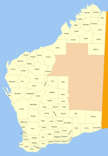
Warramboo Land District is a land district (cadastral division) of Western Australia, located within the North-West Land Division.
The lands administrative divisions of Western Australia refer to subdivisions of the state of Western Australia for cadastral purposes, most of which have been in place since the 19th century. The state is divided up for this purpose into five land divisions, which in turn are subdivided into land districts, which correspond to counties in other Australian states. These districts are then subdivided further into numbered locations, as well as gazetted townsites. Together, they form part of the lands administrative divisions of Australia.
Western Australia is a state occupying the entire western third of Australia. It is bounded by the Indian Ocean to the north and west, and the Southern Ocean to the south, the Northern Territory to the north-east, and South Australia to the south-east. Western Australia is Australia's largest state, with a total land area of 2,529,875 square kilometres, and the second-largest country subdivision in the world, surpassed only by Russia's Sakha Republic. The state has about 2.6 million inhabitants – around 11 percent of the national total – of whom the vast majority live in the south-west corner, 79 per cent of the population living in the Perth area, leaving the remainder of the state sparsely populated.
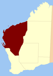
The North-West Land Division is one of five Land Divisions of Western Australia, part of the Cadastral divisions of Western Australia. It includes Carnarvon, Exmouth and Port Hedland. It is located in the Gascoyne region, the western Pilbara region, and part of the Mid West
It contains the town of Mount Magnet and the former towns of Boogardie, Lennonville and Paynesville.
Mount Magnet is one of the Mid West region’s original gold mining towns, and the longest surviving gold mining settlement in Western Australia. The prominent hill that is adjacent to the current townsite was called West Mount Magnet in 1854 by explorer Robert Austin, having named a smaller hill 64 km away, East Mount Magnet. Both hills had an extremely high iron content which affected the readings of his compass. West Mount Magnet had its Aboriginal name reinstated by the Surveyor General in 1972, 'Warramboo," meaning campfire camping place. The magnetic variation at Mount Magnet is zero: magnetic north equals true north.
Boogardie is an abandoned town in the Mid West of Western Australia.
Lennonville is a derelict town in Western Australia near the town of Mount Magnet, established in 1898.
Coordinates: 28°05′S117°50′E / 28.083°S 117.833°E
A geographic coordinate system is a coordinate system that enables every location on Earth to be specified by a set of numbers, letters or symbols. The coordinates are often chosen such that one of the numbers represents a vertical position and two or three of the numbers represent a horizontal position; alternatively, a geographic position may be expressed in a combined three-dimensional Cartesian vector. A common choice of coordinates is latitude, longitude and elevation. To specify a location on a plane requires a map projection.
This article about a location in Western Australia is a stub. You can help Wikipedia by expanding it. |
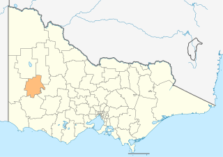
The Rural City of Horsham is a local government area in Victoria, Australia, located in the western part of the state. It covers an area of 4,249 square kilometres (1,641 sq mi) and, In April 2018 it had a population of over 20,000. It includes the towns of Brimpaen, Dadswells Bridge, Dooen, Haven, Horsham, Laharum, Natimuk, Noradjuha and Pimpinio. It was formed in 1995 by the amalgamation of the City of Horsham, most of the Shire of Wimmera and Shire of Arapiles, and part of the Shire of Kowree.
Kalulushi is a town in the Copperbelt Province in north central Zambia. Municipal (district) population 75,806 at the 2000 Census. There is a famous story of the origin of the name Kalulushi. The story goes like this. Two gentlemen went hunting for rabbits. Rabbits, in Zambia's main local language, are referred to as "kalulu." During their hunt they eventually spotted one rabbit. One of the gentlemen in excitement called out "kalulu!". The other gentlemen quietly told his friend, "shhhh" in order to avoid alarming the rabbit and prevent the rabbit from running away. So that's how the name Kalulushi came about. And so the story goes. Kalulushi was established in 1953 as a company town for workers at the nearby Chibuluma copper and cobalt mine, and it became a public town in 1958. It is located 14 km (9 mi) west of Kitwe, the nearest rail station, at an altitude of 1,260 m (4,130 ft). The city's major employer is Chambishi metals. The Chati Forest Reserve west of the city manages large plantations of eucalyptus, tropical pine, and other exotic tree species supplying wood for the mining industry. The Woods are also supplied to ZESCO an electricity company.
Borchgrevink Glacier is a large glacier in the Victory Mountains, Victoria Land, draining south between Malta Plateau and Daniell Peninsula, and thence projecting into Glacier Strait, Ross Sea, as a floating glacier tongue, the Borchgrevink Glacier Tongue, just south of Cape Jones. It was named by the New Zealand Geological Survey Antarctic Expedition, 1957–58, for Carsten Borchgrevink, leader of the British Antarctic Expedition, 1898–1900. Borchgrevink visited the area in February 1900 and first observed the seaward portion of the glacier.
Rivica is a village in Serbia. It is situated in the Irig municipality, in the Srem District, Vojvodina province. The village has a Serb ethnic majority and its population numbering 657 people.
Baghdati is a district of Georgia, in the region of Imereti. Its main town is Baghdati.
Al Haymah Al Kharijiyah District is a district of the Sana'a Governorate, Yemen. As of 2003, the district had a population of 58,454 inhabitants.
Buningonia Land District is a land district of Western Australia, located within the Eastern Land Division on the Nullarbor Plain. It spans roughly 30°10'S - 32°00'S in latitude and 122°15'E - 124°00'E in longitude.
Yilgarn Land District is a land district of Western Australia, located within the Eastern Land Division.
Malcolm Land District is a land district of Western Australia, located within the Eastern Land Division in the northern Goldfields region of the state.
Hampton Land District is a land district of Western Australia, located within the Eastern Land Division in the Goldfields region of the state.
Plantagenet Land District is a land district of Western Australia, located within the South West Division.
Williams Land District is a land district of Western Australia, located within the South West Division.
De Grey Land District is a land district of Western Australia and a subdivision of the North-West Land Division. It includes the Pilbara towns of Marble Bar and Nullagine and the former town of Goldsworthy.
Nookawarra Land District is a land district of Western Australia, located within the North-West Land Division.
Kyarra Land District is a land district of Western Australia, located within the North-West Land Division.
Hardey Land District is a land district of Western Australia, located within the North-West Land Division.
Erivilla Land District is a land district of Western Australia, located within the North-West Land Division.
Doongan Land District is a land district of Western Australia, located within the Kimberley Land Division in the Kimberley region of the state.
Streatorland is an informal name given to the geographic area in North Central Illinois that is centered geographically, politically, culturally, and economically, around the city of Streator. It consists of areas in southern LaSalle County and northwestern Livingston. It can be more broadly defined as the area east of Interstate 39, west of Interstate 55, and south of the Illinois River. Depending on the source, the panhandle of LaSalle County can be considered a part of Streatorland. There are several small towns that lie in the Streatorland area and filter into the Streator school district, though there are other schools in the area.
Pyatnitsky, Pyatnitskaya, or Pyatnitskoye is the name of several inhabited localities in Russia.