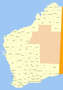
Luman Land District

Last updated

Luman
Western Australia
Western Australia land districts.png

Luman Land District is a land district (cadastral division) of Western Australia, located within the Kimberley Division of the state.

The lands administrative divisions of Western Australia refer to subdivisions of the state of Western Australia for cadastral purposes, most of which have been in place since the 19th century. The state is divided up for this purpose into five land divisions, which in turn are subdivided into land districts, which correspond to counties in other Australian states. These districts are then subdivided further into numbered locations, as well as gazetted townsites. Together, they form part of the lands administrative divisions of Australia.

Western Australia State in Australia

Western Australia is a state occupying the entire western third of Australia. It is bounded by the Indian Ocean to the north and west, and the Southern Ocean to the south, the Northern Territory to the north-east, and South Australia to the south-east. Western Australia is Australia's largest state, with a total land area of 2,529,875 square kilometres, and the second-largest country subdivision in the world, surpassed only by Russia's Sakha Republic. The state has about 2.6 million inhabitants – around 11 percent of the national total – of whom the vast majority live in the south-west corner, 79 per cent of the population living in the Perth area, leaving the remainder of the state sparsely populated.


Coordinates: 17°20′S128°10′E / 17.333°S 128.167°E / -17.333; 128.167

Geographic coordinate system Coordinate system

A geographic coordinate system is a coordinate system that enables every location on Earth to be specified by a set of numbers, letters or symbols. The coordinates are often chosen such that one of the numbers represents a vertical position and two or three of the numbers represent a horizontal position; alternatively, a geographic position may be expressed in a combined three-dimensional Cartesian vector. A common choice of coordinates is latitude, longitude and elevation. To specify a location on a plane requires a map projection.


Related Research Articles

Porpoise Bay, Antarctica bay in Antarctica

Porpoise Bay is an ice-filled embayment about 90 miles (140 km) wide indenting the coast of Antarctica between Cape Goodenough and Cape Morse. The United States Exploring Expedition (1838–42) under Charles Wilkes applied the name "Porpoise Bay", after the USEE brig "Porpoise", to a large bay at about 66°S, 130°E. US-ACAN's identification of Porpoise Bay is based on the correlation of Wilkes' chart (1840) with G.D. Blodgett's reconnaissance map (1955) compiled from air photos taken by USN Operation Highjump (1946–47). The name has been applied to the large embayment lying close southwest in keeping with Wilkes' original naming.

Kohat District District in Khyber Pakhtunkhwa Province, Pakistan

Kohat District is a district in Kohat Division of Khyber Pakhtunkhwa province in Pakistan, Kohat city is the capital of the district.

Lago da Pedra Municipality in Nordeste, Brazil

Lago da Pedra is a municipality in the state of Maranhão in the Northeast region of Brazil. In 2010 Census, its population was 46,083 inhabitants. Along with Lago do Junco, Lago dos Rodrigues, Lagoa Grande do Maranhão and Poção de Pedras, Lago da Pedra is located in Lakes Region, an area for sustainable exploration of babassu.

Lukulu District District in Western Province, Zambia

Lukulu District is a district of Zambia, located in Western Province. The capital lies at Lukulu. As of the 2000 Zambian Census, the district had a population of 68,375 people.

Kitaf wa Al Boqe'e District is a district of the Sa'dah Governorate, Yemen. As of 2003, the district had a population of 43,034 inhabitants.

Bulara Land District Cadastral in Western Australia

Bulara Land District is a land district of Western Australia, located within the Kimberley Division of the state.

Omalinde Land District Cadastral in Western Australia

Omalinde Land District is one of the land districts of Western Australia, located within the Kimberley Division of the state.

Yelina Land District Cadastral in Western Australia

Yelina Land District is a land district of Western Australia, located within the Eastern Land Division.

Ngalbain Land District Cadastral in Western Australia

Ngalbain Land District is a land district of Western Australia, located within the Eastern Land Division.

Cockburn Sound Land District Cadastral in Western Australia

Cockburn Sound Land District is a land district of Western Australia, located within the South West Division.

Plantagenet Land District Cadastral in Western Australia

Plantagenet Land District is a land district of Western Australia, located within the South West Division.

De Grey Land District Cadastral in Western Australia

De Grey Land District is a land district of Western Australia and a subdivision of the North-West Land Division. It includes the Pilbara towns of Marble Bar and Nullagine and the former town of Goldsworthy.

De Witt Land District Cadastral in Western Australia

De Witt District is a land district of Western Australia, located within the North-West Land Division.

Peawah Land District Cadastral in Western Australia

Peawah Land District is a land district of Western Australia, located within the North-West Land Division.

Lyndon Land District Cadastral in Western Australia

Lyndon Land District is a land district of Western Australia, located within the North-West Land Division.

Kyarra Land District Cadastral in Western Australia

Kyarra Land District is a land district of Western Australia, located within the North-West Land Division.

Gregory Land District Cadastral in Western Australia

Gregory Land District is a land district of Western Australia, located within the North-West Land Division.

Hardey Land District Cadastral in Western Australia

Hardey Land District is a land district of Western Australia, located within the North-West Land Division.

Giles Land District Cadastral in Western Australia

Giles Land District is a land district of Western Australia, located within the Eastern and Eucla land divisions on the Nullarbor Plain. It spans roughly 29°00'S - 31°00'S in latitude and 123°30'E - 126°30'E in longitude.

The Electoral district of Castlemaine and Kyneton was an electoral district of the Victorian Legislative Assembly (Australia).