Eastern Land Division

Last updated

Eastern Land Division
Eastern land division of Western Australia.png
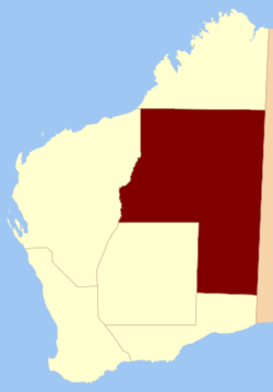
Location within Western Australia prior to 1917
Coordinates: Coordinates: 24°45′S125°00′E / 24.750°S 125.000°E / -24.750; 125.000
CountryFlag of Australia (converted).svg  Australia
State Western Australia
Regions Goldfields–Esperance
Pilbara
Land districts40 land districts

The Eastern Land Division is one of five cadastral land divisions Western Australia, Australia, within the eastern parts of the Goldfields-Esperance region and the Pilbara region. Most of its territory is covered by deserts, including the part of the Great Sandy Desert, Gibson Desert and Great Victoria Desert. [1]

Contents

History

The Eastern Land Division was created on 2 March 1887, in a reform to the land divisions. [2] On 28 March 1917, the Central Land Division had been incorporated into the Eastern Land Division. [3] The current boundaries of the land enacted on 30 March 1998. [1] [4]

Prior to the construction of the Trans-Australian Railway in 1917, the Eastern Land Division, which consists almost entirely of the Great Victoria and Great Sandy Deserts, did not contain any districts. [5]

Subdivisions

The Eastern Land Division is subdivided into 40 land districts.

DistrictLocationCreatedNotes
Balladonia 32°15′S123°35′E / 32.250°S 123.583°E / -32.250; 123.583 (Balladonia Land District) 1897Partially located within Eucla Land Division
Balwina 20°15′S127°40′E / 20.250°S 127.667°E / -20.250; 127.667 (Balwina Land District) 1928
Bulga 28°25′S119°40′E / 28.417°S 119.667°E / -28.417; 119.667 (Bulga Land District) 1903
Buningonia 31°05′S123°05′E / 31.083°S 123.083°E / -31.083; 123.083 (Buningonia Land District) 1903
Delisser 30°00′S127°45′E / 30.000°S 127.750°E / -30.000; 127.750 (Delisser Land District) 1916
Dempster 32°40′S122°55′E / 32.667°S 122.917°E / -32.667; 122.917 (Dempster Land District) 1897Partially located within Eucla Land Division
Edjudina 29°25′S122°35′E / 29.417°S 122.583°E / -29.417; 122.583 (Edjudina Land District) 1903
Fraser 32°00′S122°45′E / 32.000°S 122.750°E / -32.000; 122.750 (Fraser Land District) 1897Partially located within Eucla Land Division
Giles 30°00′S125°20′E / 30.000°S 125.333°E / -30.000; 125.333 (Giles Land District) 1916Partially located within Eucla Land Division
Hampton 30°50′S121°40′E / 30.833°S 121.667°E / -30.833; 121.667 (Hampton Land District) 1899
Hann 24°50′S120°50′E / 24.833°S 120.833°E / -24.833; 120.833 (Hann Land District) 1925
Jaurdi 30°25′S120°50′E / 30.417°S 120.833°E / -30.417; 120.833 (Jaurdi Land District) 1903
Jilbadji 31°25′S119°25′E / 31.417°S 119.417°E / -31.417; 119.417 (Jilbadji Land District) 1903
Kaluwiri 27°50′S120°40′E / 27.833°S 120.667°E / -27.833; 120.667 (Kaluwiri Land District) 1903
Malcolm 28°50′S121°20′E / 28.833°S 121.333°E / -28.833; 121.333 (Malcolm Land District) 1900
Marmion 29°40′S121°10′E / 29.667°S 121.167°E / -29.667; 121.167 (Marmion Land District) 1899
Milyuga 25°25′S127°25′E / 25.417°S 127.417°E / -25.417; 127.417 (Milyuga Land District) 1932
Nabberu 26°35′S120°10′E / 26.583°S 120.167°E / -26.583; 120.167 (Nabberu Land District) 1903
Ngalbain 31°20′S121°10′E / 31.333°S 121.167°E / -31.333; 121.167 (Ngalbain Land District) 1903
Nuleri 27°40′S122°10′E / 27.667°S 122.167°E / -27.667; 122.167 (Nuleri Land District) 1903
Pardu 19°50′S120°40′E / 19.833°S 120.667°E / -19.833; 120.667 (Pardu Land District) 1906Partially located within Kimberley and North-West Land Divisions
Tugaila 25°25′S124°25′E / 25.417°S 124.417°E / -25.417; 124.417 (Tugaila Land District) 1932
Ularring 29°25′S120°05′E / 29.417°S 120.083°E / -29.417; 120.083 (Ularring Land District) 1903
Wanman 22°10′S123°50′E / 22.167°S 123.833°E / -22.167; 123.833 (Wanman Land District) 1950s
Weld 28°40′S122°25′E / 28.667°S 122.417°E / -28.667; 122.417 (Weld Land District) 1901
Wells 25°15′S122°30′E / 25.250°S 122.500°E / -25.250; 122.500 (Wells Land District) 1925
Yamarna 28°10′S123°40′E / 28.167°S 123.667°E / -28.167; 123.667 (Yamarna Land District) 1930
Yelina 26°20′S122°10′E / 26.333°S 122.167°E / -26.333; 122.167 (Yelina Land District) 1903
Yilgarn 30°50′S119°05′E / 30.833°S 119.083°E / -30.833; 119.083 (Yilgarn Land District) 1900
Yowalga 27°55′S127°00′E / 27.917°S 127.000°E / -27.917; 127.000 (Yowalga Land District) 1932

Related Research Articles

<span class="mw-page-title-main">Great Victoria Desert</span> Desert in Western Australia and South Australia

The Great Victoria Desert is a sparsely populated desert ecoregion and interim Australian bioregion in Western Australia and South Australia.

<span class="mw-page-title-main">Little Desert National Park</span> Protected area in Victoria, Australia

The Little Desert National Park is a national park in the Wimmera Mallee region of Victoria, Australia. The 132,647-hectare (327,780-acre) national park is situated near Dimboola, approximately 375 kilometres (233 mi) west of Melbourne and extends from the Wimmera River in the east to the South Australian border in the west near Naracoorte.

<span class="mw-page-title-main">Great Sandy Desert</span> Desert in Northern Western Australia

The Great Sandy Desert is an interim Australian bioregion, located in the northeast of Western Australia straddling the Pilbara and southern Kimberley regions and extending east into the Northern Territory. It is the second largest desert in Australia after the Great Victoria Desert and encompasses an area of 284,993 square kilometres (110,036 sq mi). The Gibson Desert lies to the south and the Tanami Desert lies to the east of the Great Sandy Desert.

<span class="mw-page-title-main">Great American Desert</span> Historical term for the High Plains region of North America

The term Great American Desert was used in the 19th century to describe the part of North America east of the Rocky Mountains to about the 100th meridian. It can be traced to Stephen H. Long's 1820 scientific expedition which put the Great American Desert on the map.

<span class="mw-page-title-main">Gibson Desert</span> Desert in Western Australia

The Gibson Desert is a large desert in Western Australia, largely in an almost "pristine" state. It is about 155,000 square kilometres (60,000 sq mi) in size, making it the fifth largest desert in Australia, after the Great Victoria, Great Sandy, Tanami and Simpson deserts. The Gibson Desert is both an interim Australian bioregion and desert ecoregion.

<span class="mw-page-title-main">Little Sandy Desert</span> Ecoregion and desert in Western Australia

The Little Sandy Desert (LSD) is a desert region in the state of Western Australia, lying to the east of the Pilbara and north of the Gascoyne regions. It is part of the Western Desert cultural region, and was declared an interim Australian bioregion in the 1990s.

<span class="mw-page-title-main">Far North (South Australia)</span> Region in South Australia

The Far North is a large region of South Australia close to the Northern Territory border. Colloquial usage of the term in South Australia refers to that part of South Australia north of a line roughly from Ceduna through Port Augusta to Broken Hill. The South Australian Government defines the Far North region similarly with the exception of the Maralinga Tjarutja Lands, the Yalata Aboriginal community and other unincorporated crown lands in the state's far west, which are officially considered part of the Eyre and Western region.

<span class="mw-page-title-main">Deserts of Australia</span> Deserts in Australia

The deserts of Australia or the Australian deserts cover about 2,700,000 km2 (1,000,000 sq mi), or 18% of the Australian mainland, but about 35% of the Australian continent receives so little rain, it is practically desert. Collectively known as the Great Australian desert, they are primarily distributed throughout the Western Plateau and interior lowlands of the country, covering areas from South West Queensland, Far West region of New South Wales, Sunraysia in Victoria and Spencer Gulf in South Australia to the Barkly Tableland in Northern Territory and the Kimberley region in Western Australia.

<span class="mw-page-title-main">Shire of Kilkivan</span> Local government area in Queensland, Australia

The Shire of Kilkivan was a local government area about 180 kilometres (112 mi) north-northwest of Brisbane, the state capital of Queensland, Australia. The shire covered an area of 3,263.4 square kilometres (1,260.0 sq mi), and existed from 1886 until its merger with several other local government areas to form the Gympie Region on 15 March 2008.

<span class="mw-page-title-main">Lands administrative divisions of Australia</span> Cadastral divisions of Australia for land identification purposes

Lands administrative divisions of Australia are the cadastral divisions of Australia for the purposes of identification of land to ensure security of land ownership. Most states term these divisions as counties, parishes, hundreds, and other terms. The eastern states of Queensland, New South Wales, Victoria, and Tasmania were divided into counties and parishes in the 19th century, although the Tasmanian counties were renamed land districts in the 20th century. Parts of South Australia (south-east) and Western Australia (south-west) were similarly divided into counties, and there were also five counties in a small part of the Northern Territory. However South Australia has subdivisions of hundreds instead of parishes, along with the Northern Territory, which was part of South Australia when the hundreds were proclaimed. There were also formerly hundreds in Tasmania. There have been at least 600 counties, 544 hundreds and at least 15,692 parishes in Australia, but there are none of these units for most of the sparsely inhabited central and western parts of the country.

The lands administrative divisions of Western Australia refer to subdivisions of the state of Western Australia for cadastral purposes, most of which have been in place since the 19th century. The state is divided up for this purpose into five land divisions, which in turn are subdivided into land districts, which correspond to counties in other Australian states. These districts are then subdivided further into numbered locations, as well as gazetted townsites. Together, they form part of the lands administrative divisions of Australia.

<span class="mw-page-title-main">Kimberley Land Division</span>

Kimberley Land Division is one of five land divisions of Western Australia recognised in the Land Administration Act 1997. It occupies roughly the same area as the Kimberley region of the state.

<span class="mw-page-title-main">Gascoyne Land Division</span>

Gascoyne Land Division was a land division of Western Australia defined under the Land Regulations of 2 March 1887. It included almost all of the modern Gascoyne region of the State. In the Land Act 1898, it was renamed Western to avoid confusion with the Gascoyne Land District which had just been created by the Department of Lands and Surveys, and on 1 February 1907, section 26 of the Land Act Amendment Act 1906 merged it into North-West Land Division.

<span class="mw-page-title-main">Yowalga Land District</span> Cadastral in Western Australia

Yowalga Land District is a land district of Western Australia, located within the Eastern Land Division in the Great Victoria Desert, north of the Nullarbor Plain. It spans roughly 26°50'S - 29°00'S in latitude and 125°00'E - 129°00'E in longitude.

<span class="mw-page-title-main">Yamarna Land District</span> Cadastral in Western Australia

Yamarna Land District is a land district of Western Australia, located within the Eastern Land Division in the Great Victoria Desert, north of the Nullarbor Plain. It spans roughly 26°50'S - 29°00'S in latitude and 123°30'E - 125°00'E in longitude.

<span class="mw-page-title-main">Balwina Land District</span> Cadastral in Western Australia

Balwina Land District is a land district of Western Australia, located within the Eastern Land Division in the Great Sandy Desert. It spans roughly 19°30'S - 21°00'S in latitude and 126°25'E - 129°00'E in longitude.

Tallaringa Conservation Park is a protected area located in the west of the Australian state of South Australia about 615 kilometres north west of the city of Port Augusta and about 90 kilometres west of the town of Coober Pedy. The conservation park was proclaimed under the National Parks and Wildlife Act 1972 in 1991.

<span class="mw-page-title-main">Mainland Australia</span> Largest island of Australia

Mainland Australia is the main landmass of the Australian continent, excluding the Aru Islands, New Guinea, Tasmania, and other Australian offshore islands. The landmass also constitutes the mainland of the territory governed by the Commonwealth of Australia, and the term, along with continental Australia, can be used in a geographic sense to exclude surrounding continental islands and external territories. Generally, the term is applied to the states of New South Wales, Queensland, South Australia, Victoria, and Western Australia, as well as the Australian Capital Territory, Jervis Bay Territory, and Northern Territory.

References

  1. 1 2 "LAND ADMINISTRATION ACT 1997 - SCHEDULE 1" . Retrieved 1 December 2010.
  2. "Land Regulations. Part III — Division of the Colony". Western Australia Government Gazette. 2 March 1887. p. 1887:133.
  3. Land Act Amendment Act 1917 (No. 19), s. 4.
  4. Land Administration Act 1997. Proclamation. In: Western Australia Government Gazette. 27 March 1998. p. 1998:1765.
  5. Western Australia. Dept. of Lands and Surveys (1913). South western portion of Western Australia shewing land districts (map), Government Lithographer, Perth.