The Goldfields–Esperance region is one of the nine regions of Western Australia. It is located in the south-eastern corner of Western Australia, and comprises the local government areas of Coolgardie, Dundas, Esperance, Kalgoorlie–Boulder, Laverton, Leonora, Menzies, Ngaanyatjarraku, Ravensthorpe and Wiluna.
The Eucla Basin is an artesian depression located in Western Australia and South Australia. The onshore-offshore depression covers approximately 1,141,000 km2 and slopes southward to an open bay known as the Great Australian Bight.
The lands administrative divisions of Western Australia refer to subdivisions of the state of Western Australia for cadastral purposes, most of which have been in place since the 19th century. The state is divided up for this purpose into five land divisions, which in turn are subdivided into land districts, which correspond to counties in other Australian states. These districts are then subdivided further into numbered locations, as well as gazetted townsites. Together, they form part of the lands administrative divisions of Australia.
The Eastern Land Division is one of five cadastral divisions of Western Australia, within the eastern parts of the Goldfields-Esperance region and the Pilbara region. Most of its territory is covered by deserts, including the part of the Great Sandy Desert, Gibson Desert and Great Victoria Desert.
Western Australia has the longest coastline of any state or territory in Australia, at 10,194 km or 12,889 km. It is a significant portion of the coastline of Australia, which is 35,877 km.
The south coast of Western Australia comprises the Western Australian coastline from Cape Leeuwin to Eucla. This is a distance of approximately 1,600 kilometres (1,000 mi), fronting the Great Australian Bight and the Southern Ocean.
Mining in Western Australia is administered in terms of the administrative divisions of the:-

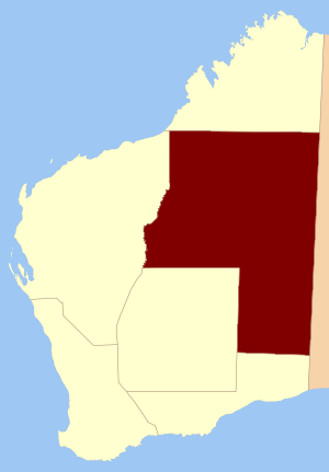
Balladonia Land District is a land district of Western Australia mostly within the Eucla Land Division. It spans roughly 31°50'S - 32°40'S in latitude and 123°10'E - 124°00'E in longitude.
Nurina Land District is a land district of Western Australia, located within the Eucla Land Division on the Nullarbor Plain. It spans roughly 31°00'S - 32°20'S in latitude and 125°30'E - 127°30'E in longitude.
Neridup Land District is a land district of Western Australia, located within the Eucla Land Division on the state's south coast. It spans roughly 33°15'S - 34°00'S in latitude and 122°20'E - 123°30'E in longitude.
Mundrabilla Land District is a land district of Western Australia, located within the Eucla Land Division on the Nullarbor Plain. It spans roughly 31°00'S - 32°00'S in latitude and 127°30'E - 129°00'E in longitude.
Mardarbilla Land District is a land district of Western Australia located within the Eucla Land Division on the western edge of the Great Australian Bight. It spans roughly 32°40'S – 33°55'S in latitude and 123°30'E – 124°00'E in longitude. Much of the district is within the Cape Arid National Park, and it contains the town of Israelite Bay.
Fitzgerald Land District is a land district of Western Australia, located within the Eucla Land Division inland from Esperance. It spans roughly 32°35'S - 33°15'S in latitude and 121°00'E - 122°15'E in longitude.
Esperance Land District is a land district of Western Australia, located within the Eucla Land Division on the state's south coast. It spans roughly 33°15'S - 34°00'S in latitude and 121°00'E - 122°20'E in longitude.
Dundas Land District is a land district of Western Australia within the Eucla Land Division. It spans roughly 31°40'S - 32°40'S in latitude and 121°00'E - 122°15'E in longitude.
Fraser Land District is a land district of Western Australia partly within the Eucla and Eastern divisions of the state. It spans roughly 31°40'S - 32°25'S in latitude and 122°15'E - 123°10'E in longitude.
Nuyts Land District is a land district of Western Australia, located within the Eastern and Eucla land divisions on the Nullarbor Plain. It spans roughly 31°00'S - 32°50'S in latitude and 124°00'E - 125°30'E in longitude.
Oldfield Land District is a land district of Western Australia partly within the Eucla and South-West divisions on the state's south coast. It spans roughly 33°15'S - 34°00'S in latitude and 119°45'E - 121°10'E in longitude.
Giles Land District is a land district of Western Australia, located within the Eastern and Eucla land divisions on the Nullarbor Plain. It spans roughly 29°00'S - 31°00'S in latitude and 123°30'E - 126°30'E in longitude.
Land systems of Western Australia are systematic land resource concepts where the tying in of geographical, geological, and ecological data is processed to provide land planning and land management systems with sets of information that can process large areas of land in terms of agricultural and other usages.
