A hundred is an administrative division that is geographically part of a larger region. It was formerly used in England, Wales, some parts of the United States, Denmark, Southern Schleswig, Sweden, Finland, Norway, the Bishopric of Ösel–Wiek, Curonia, the Ukrainian state of the Cossack Hetmanate and in Cumberland County in the British Colony of New South Wales. It is still used in other places, including in Australia.

Tannum Sands is a coastal town and locality in the Gladstone Region, Queensland, Australia.
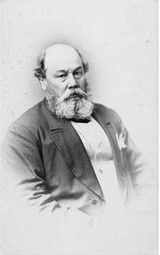
Sir Arthur Blyth was Premier of South Australia three times; 1864–65, 1871–72 and 1873–75.
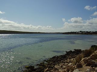
Coffin Bay, originally Coffin's Bay, is a town at the southern extremity of the Eyre Peninsula, a wheat growing area of South Australia. At the 2016 census, Coffin Bay had a population of 611.

Lands administrative divisions of Australia are the cadastral divisions of Australia for the purposes of identification of land to ensure security of land ownership. Most states term these divisions as counties, parishes, hundreds, and other terms. The eastern states of Queensland, New South Wales, Victoria, and Tasmania were divided into counties and parishes in the 19th century, although the Tasmanian counties were renamed land districts in the 20th century. Parts of South Australia (south-east) and Western Australia (south-west) were similarly divided into counties, and there were also five counties in a small part of the Northern Territory. However South Australia has subdivisions of hundreds instead of parishes, along with the Northern Territory, which was part of South Australia when the hundreds were proclaimed. There were also formerly hundreds in Tasmania. There have been at least 600 counties, 544 hundreds and at least 15,692 parishes in Australia, but there are none of these units for most of the sparsely inhabited central and western parts of the country.

Palmerston County is one of the five counties in the Northern Territory of Australia which are part of the Lands administrative divisions of Australia. It contains the city of Darwin. It was proclaimed on 14 September 1871 and divided into hundreds. Being on the northern coast of the territory, it is bounded on the north and west by sea, the Adelaide River on the east and on the south by a line at longitude approximately 13°15' south.
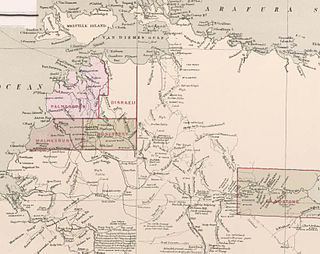
Roseberry County is one of the five counties in the Northern Territory which are part of the cadastral divisions of Australia. The County of Rosebery was gazetted on 15 July 1885 and covered the area north of Pine Creek. The county was not subdivided into hundreds.

The Hundred of Bagot is the cadastral unit of hundred for the city of Darwin, Northern Territory and the city of Palmerston. It includes the Local Government Areas of the City of Darwin, the northern part of the City of Palmerston and part of the north-western edge of the Shire of Litchfield.
Southport is an outer rural locality in Darwin. It is based on the site of the abandoned Town of Southport, a thriving river port during the Pine Creek gold rush of the 1870s. It is located at the junction of the Blackmore and Darwin Rivers.

The Towns River is a river in the Northern Territory, Australia.

The County of Robe is one of the 49 cadastral counties of South Australia. It was proclaimed by and named for Governor Frederick Robe in 1846. It covers a portion of the state's south-east from the west coast at Robe to the border with Victoria on the east. This includes the following contemporary local government areas of the state:
County of Gladstone was one of the five counties in the Northern Territory which are part of the cadastral divisions of Australia.
The Hundred of Beaconsfield was a hundred within the now-lapsed County of Disraeli in the Northern Territory of Australia.

The Hundred of Glynne was a Hundred of Gladstone County, Northern Territory Australia.
The Hundred of Bundey was a hundred within County of Disraeli in the Northern Territory of Australia. The hundred was gazetted on 7 August 1884 and lapsed with the passage in 1976 and subsequent assent of the Crown Lands Ordinance 1976 and the Crown Lands Ordinance 1976.
County of Malmesbury was one of the five counties in the Northern Territory which are part of the Lands administrative divisions of Australia.
Hundred of Hawarden was a Hundred of Gladstone County, Northern Territory of Australia.

The Hundred of Reynolds was a hundred of the County of Gladstone in the Northern Territory of Australia which was created in 1873 and which lapsed in 1976. It is located 600 km south-east of the territorial capital of Darwin.

County of Hanson is a cadastral unit located in the Australian state of South Australia that covers land in the Flinders Ranges immediately east of the town of Hawker. It was proclaimed on 20 July 1877 and is named after Sir Richard Davies Hanson who served as Premier, Administrator and Chief Justice of South Australia. It has been partially divided in the following sub-units of hundreds – Adams, Arkaba, French, Moralana and Warcowie.
Rakula is a locality in the Northern Territory of Australia located about 72 kilometres (45 mi) south-west of the territorial capital of Darwin.

