Hundred of Glynne

Last updated
Goodwill (ship) at Ngukurr in 1917 StateLibQld 1 113736 Goodwill (ship).jpg
Goodwill (ship) at Ngukurr in 1917
Map of the Roper River based on the 1886 map by John Sands. Hawarden Hundred Northern Territory.png
Map of the Roper River based on the 1886 map by John Sands.

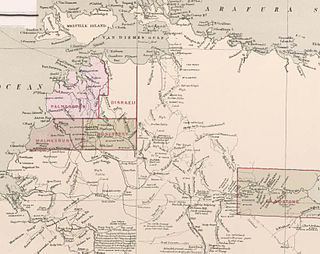
The Hundred of Glynne was a Hundred of Gladstone County, Northern Territory Australia. [2]

A hundred is an administrative division that is geographically part of a larger region. It was formerly used in England, Wales, some parts of the United States, Denmark, Southern Schleswig, Sweden, Finland, Estonia, and Norway. It is still used in other places, including South Australia, and The Northern Territory.

Northern Territory federal territory of Australia

The Northern Territory is an Australian territory in the central and central northern regions of Australia. It shares borders with Western Australia to the west, South Australia to the south, and Queensland to the east. To the north, the territory looks out to the Timor Sea, the Arafura Sea and the Gulf of Carpentaria, including Western New Guinea and other Indonesian islands. The NT covers 1,349,129 square kilometres (520,902 sq mi), making it the third-largest Australian federal division, and the 11th-largest country subdivision in the world. It is sparsely populated, with a population of only 246,700, making it the least-populous of Australia's eight states and major territories, with fewer than half as many people as Tasmania.

It is located 600 km southeast of Darwin, at Latitude: -14° 38' S and Longitude: 134° 48' E and It was named after the wife of British Prime Minister William Ewart Gladstone, Catherine Glynne.

South one of the four cardinal directions

South is one of the four cardinal directions or compass points. South is the opposite of north and is perpendicular to the east and west.

Darwin, Northern Territory City in the Northern Territory, Australia

Darwin is the capital city of the Northern Territory of Australia, situated on the Timor Sea. It is the largest city in the sparsely populated Northern Territory, with a population of 145,916. It is the smallest, wettest and most northerly of the Australian capital cities, and acts as the Top End's regional centre.

Wife female spouse

A wife is a female partner in a continuing marital relationship.

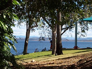
The only town in the former Hundred is the small settlement of Ngukurr.

Ngukurr Town in the Northern Territory, Australia

Ngukurr is a remote Aboriginal community on the banks of the Roper River in southern Arnhem Land, Northern Territory. A number of different clans and language groups are represented in the town, with Kriol being the main language spoken. Collectively, indigenous peoples in the Roper River area refer to themselves as Yugul Mangi, and the Yugul Mangi Aboriginal Corporation works closely with the Roper Gulf Regional Council to provide services and economic opportunities in Ngukurr and surrounding areas.

The first European to see the Hundred was Ludwig Leichhardt who crossed the Roper River at the Roper Bar in 1845, and in 1855 Augustus Charles Gregory passed to the south of the Hundred on his route to Gladstone, Queensland. This Hundred was one of just 6 Hundreds in the County of Gladstone (located in the Roper River area) which was gazetted 09/01/1873. Each of these hundreds was designed to be roughly 10 miles by 10 miles in area though some variation occurred due to the river course.

Europe Continent in the Northern Hemisphere and mostly in the Eastern Hemisphere

Europe is a continent located entirely in the Northern Hemisphere and mostly in the Eastern Hemisphere. It is bordered by the Arctic Ocean to the north, the Atlantic Ocean to the west and the Mediterranean Sea to the south. It comprises the westernmost part of Eurasia.

Ludwig Leichhardt German explorer of Australia

Friedrich Wilhelm Ludwig Leichhardt, known as Ludwig Leichhardt, was a German explorer and naturalist, most famous for his exploration of northern and central Australia.

Roper Bar, Northern Territory Town in the Northern Territory, Australia

Roper Bar is a location in Australia's Northern Territory. It lies on the traditional land of the Ngalakgan people who used the placename Yurlhbunji to refer to Roper Bar. This part of Australia is extremely remote for travellers although there are a number of Aboriginal communities in the region including Ngukurr, Urapunga and Minyerri. A 4WD trek through these parts can be an extension of the Gulf Track on a journey further up north to Darwin or Arnhem Land.


The Hundred lapsed with the passage in 1976 and subsequent assent of the Crown Lands Ordinace 1976 (No 1 of 1977) and the Crown Lands (Validation of Proclamations) Ordinance 1976. In 2012 the souther fringe of the hundred was incorporated into the Limmen National Park.

Limmen National Park Protected area in the Northern Territory, Australia

Limmen National Park, announced in 2012, is the second largest in Australia covering 10,000 square kilometres (3,900 sq mi) in the Northern Territory. Located about 600 km south-east of Darwin on the Gulf of Carpentaria, the park incorporates wetlands, sandstone structures and numerous rivers, including the Limmen Bight River from which the park takes its name. A major attraction in the park are the 'Lost Cities'—sandstone rock formations resembling tall apartment blocks.

Related Research Articles

Hawarden village, community and electoral ward in Flintshire, Wales

Hawarden, Flintshire, Wales is a village and community in part of the Deeside conurbation on the Welsh/English border and was historically significant settlement in the area, see Hawarden Castle. At the 2001 Census, the population of Hawarden Ward was 1,858. increasing to 1,887 at the 2011 census. The total population for the greater community of Hawarden, which comprises also Ewloe, Mancot and Aston, was 13,539, increasing to 13,920 at the 2011 census. The scenic, wooded Hawarden Park forms the southern part of the community. Hawarden Bridge is the industrial development that lies across Shotton/Queensferry and the Dee. The west of the main street is called The Highway, its start marked by the crossroads with the fountain in the middle, near which are public houses, some centred on restaurants.

Lands administrative divisions of New South Wales Wikimedia list article

The lands administrative divisions of New South Wales refers to the 141 counties within the Colony of New South Wales, that later became the Australian state of New South Wales.

Lands administrative divisions of Australia

Lands administrative divisions of Australia are the cadastral divisions of Australia for the purposes of identification of land to ensure security of land ownership. Most states term these divisions as counties, parishes, hundreds, and other terms. The eastern states of Queensland, New South Wales, Victoria and Tasmania were divided into counties and parishes in the 19th century, although the Tasmanian counties were renamed land districts in the 20th century. Parts of South Australia (south-east) and Western Australia (south-west) were similarly divided into counties, and there were also five counties in a small part of the Northern Territory. However South Australia has subdivisions of hundreds instead of parishes, along with the Northern Territory, which was part of South Australia when the hundreds were proclaimed. There were also formerly hundreds in Tasmania. There have been at least 600 counties, 544 hundreds and at least 15,692 parishes in Australia, but there are none of these units for most of the sparsely inhabited central and western parts of the country.

Lands administrative divisions of South Australia

The lands administrative divisions of South Australia are the cadastral units of counties and hundreds in South Australia. They are located only in the south-eastern part of the state, and do not cover the whole state. 49 counties have been proclaimed across the southern and southeastern areas of the state historically considered to be arable and thus in need of a cadastre. Within that area, a total of 540 hundreds have been proclaimed, although five were annulled in 1870, and, in some cases, the names reused elsewhere.

Roseberry County Cadastral in the Northern Territory, Australia

Roseberry County is one of the five counties in the Northern Territory which are part of the cadastral divisions of Australia. The County of Rosebery was gazetted on 15 July 1885 and covered the area north of Pine Creek. The county was not subdivided into hundreds.

Boyne River (Central Queensland) river in Central Queensland, Australia

The Boyne River is a river located in Central Queensland, Australia.

Pelican Lagoon Conservation Park Protected area in South Australia

Pelican Lagoon Conservation Park is a protected area located in the Australian state of South Australia on the Dudley Peninsula on Kangaroo Island. It was dedicated in 1967 for the protection of wildlife habitat.

Mud Islands Game Reserve Protected area in South Australia

Mud Islands Game Reserve is a protected area in South Australia covering ten islands at the southern side of Lake Alexandrina about 19 kilometres south-east of Goolwa. The game reserve is described as providing ‘an ideal habitat for water birds, particularly waterfowl’ and that ‘duck shooting is permitted during open season.’ The game reserve is classified as an IUCN Category VI protected area. Since 2000, the game reserve has been located within the boundaries of the gazetted locality, Coorong.

Long Island Recreation Park Protected area in South Australia

Long Island Recreation Park is a protected area in the Australian state of South Australia occupying the full extent of Long Island in the Murray River immediately east of the city of Murray Bridge.

Murrunatta Conservation Park Protected area in South Australia

Murrunatta Conservation Park is a protected area in the Australian state of South Australia located on the Eyre Peninsula in the gazetted localities of Wangary and Wanilla about 8 kilometres west of the town centre in Wanilla and about 30 kilometres north-west of municipal seat of Port Lincoln.

Big Heath Conservation Park Protected area in South Australia

Big Heath Conservation Park is a protected area in the Australian state of South Australia located in the gazetted locality of Spence about 20 kilometres (12 mi) south-west of Naracoorte in the state's Limestone Coast region.

Mount Rescue Conservation Park Protected area in South Australia

.

County of Disraeli Cadastral in the Northern Territory, Australia

County of Disraeli is one of the five counties in the Northern Territory which are part of the cadastral divisions of Australia.

County of Gladstone (Northern Territory) Cadastral in the Northern Territory, Australia

County of Gladstone is one of the five counties in the Northern Territory which are part of the cadastral divisions of Australia.

Hundred of Douglas Cadastral in the Northern Territory, Australia

The Hundred of Douglas was a Hundred of Gladstone County, Northern Territory of Australia.

County of Malmesbury Cadastral in the Northern Territory, Australia

County of Malmesbury was one of the five counties in the Northern Territory which are part of the Lands administrative divisions of Australia.

Hundred of Hawarden

Hundred of Hawarden was a Hundred of Gladstone County, Northern Territory of Australia.

Hundred of Reynolds (Northern Territory) Cadastral in the Northern Territory, Australia

The Hundred of Reynolds was a hundred of the County of Gladstone in the Northern Territory of Australia which was created in 1873 and which lapsed in 1976. It is located 600 km south-east of the territorial capital of Darwin.

Woakwine Conservation Park Protected area in South Australia

Woakwine Conservation Park is a protected area located in the Australian state of South Australia in the locality of Robe about 272 kilometres (169 mi) south-east of the state capital of Adelaide and about 8 kilometres (5.0 mi) east of the town centre in Robe.

References

  1. John Sands, The New atlas of Australia Sydney : J. Sands, [1886]
  2. Hundred of Glynne.