Hundred of Ayers (Northern Territory)

Last updated
Map of Palmerston County in 1886, showing the Hundred of Ayers. Palmerston County 1886.jpg
Map of Palmerston County in 1886, showing the Hundred of Ayers.

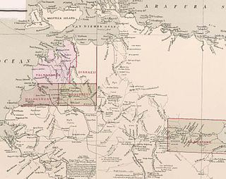
The Hundred of Ayers is a hundred within Palmerston County, in the Northern Territory, Australia. [2]

Palmerston County Cadastral in the Northern Territory, Australia

Palmerston County is one of the five counties in the Northern Territory which are part of the Lands administrative divisions of Australia. It contains the city of Darwin. It was proclaimed on 14 September 1871 and divided into hundreds. Being on the northern coast of the territory, it is bounded on the north and west by sea, the Adelaide River on the east and on the south by a line at longitude approximately 13°15' south.

Northern Territory federal territory of Australia

The Northern Territory is an Australian territory in the central and central northern regions of Australia. It shares borders with Western Australia to the west, South Australia to the south, and Queensland to the east. To the north, the territory looks out to the Timor Sea, the Arafura Sea and the Gulf of Carpentaria, including Western New Guinea and other Indonesian islands. The NT covers 1,349,129 square kilometres (520,902 sq mi), making it the third-largest Australian federal division, and the 11th-largest country subdivision in the world. It is sparsely populated, with a population of only 246,700, making it the least-populous of Australia's eight states and major territories, with fewer than half as many people as Tasmania.

The hundred is located at Coordinates: 12°38′00″S130°55′00″E / 12.633333°S 130.916667°E / -12.633333; 130.916667 and spans Berry Springs. It extends to the southern part of the Darwin Harbour and is named after Sir Henry Ayers, the Chief Secretary of South Australia who was honoured by the explorer W.C Gosse in 1873 in the naming of Ayers Rock.

Geographic coordinate system Coordinate system

A geographic coordinate system is a coordinate system that enables every location on Earth to be specified by a set of numbers, letters or symbols. The coordinates are often chosen such that one of the numbers represents a vertical position and two or three of the numbers represent a horizontal position; alternatively, a geographic position may be expressed in a combined three-dimensional Cartesian vector. A common choice of coordinates is latitude, longitude and elevation. To specify a location on a plane requires a map projection.

Berry Springs, Northern Territory Suburb of Darwin, the Northern Territory, Australia

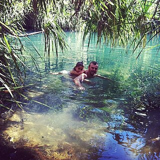
Berry Springs is an outer suburban locality in Darwin, Australia. The suburb is a mostly rural area situated on the Cox Peninsula Road and is sparsely populated. A few businesses and a school are located in the suburb. In the 2016 census, the population of Berry Springs was 818. It is located 58.5 kilometres (36.4 mi) by road from the Darwin Central Business District and lies within the Litchfield Municipality local government area.

Darwin Harbour Body of water near Australia

Darwin Harbour is the body of water close to Darwin in the Northern Territory of Australia. It opens to the north at a line from Charles Point in the west to Lee Point in the east into the Beagle Gulf and connects via the Clarence Strait with the Van Diemen Gulf. It contains Port Darwin, which is flanked by Frances Bay to the east and Cullen Bay to the west.

Related Research Articles

Posen (region)

Posen was the southern of two Prussian administrative regions, or Regierungsbezirke, of the Grand Duchy of Posen (1815–49) and its successor, the Province of Posen (1849–1918). The administrative region was bordered on the north by Regierungsbezirk Bromberg, to the west by the Province of Brandenburg, to the south by the Silesia Province, and to the east by Russian Congress Poland.

Henry Ayers Australian politician

Sir Henry Ayers was the eighth Premier of South Australia, serving a record five times between 1863 and 1873.

Vilenica Cave cave in Slovenia

Vilenica Cave or Vilenica Cave at Lokev is the oldest show cave in Europe. The first tourists to the cave were recorded in 1633. It is located next to the village of Lokev in the municipality of Sežana on the Karst Plateau in southwestern Slovenia. Until the mid-19th century it was known as the biggest, most beautiful, and most frequently visited cave of the Classical Karst. Later it was surpassed by Postojna Cave.

Sanana Island island of Indonesia

Sanana or Sula Besi Island is an island, part of Sula Islands Regency which is part of North Maluku province in Indonesia. Sanana is also the name of that island's largest settlement, home to the Dutch era fort Benteng De Verwachting.

Chryse (island) island

Chryse was a small island in the Aegean Sea mentioned by Homer, Sophocles and Pausanias.

Zavoj village in Macedonia

Zavoj is a village in North Macedonia, about 20 km from Ohrid. A small village, there are no shops or schools in Zavoj. There are about a hundred houses and it houses a church of Sv. Bogorodica where thousands gather to the village to celebrate the Holy Day on 28 August every year.

The Siege of the city of Danzig was a six-month siege in 1577 of the city of Danzig, the Polish-Lithuanian Commonwealth by Stephen Báthory the head of state of the Commonwealth. The siege ended in a negotiated agreement. It is formed part of the Danzig rebellion

Siege of Danzig (1655–60) siege

The Siege of Danzig took place between 1655 and 1660 when a Swedish force tried to capture this important Baltic Sea port city from the Polish-Lithuanian Commonwealth during the Second Northern War. After 5 years of fighting around Danzig (Gdańsk), the Swedish force which has made little ground surrendered.

The Bay of Ceuta is a bay on the African coast of the Straits of Gibraltar. It accounts for the majority of the north coast of the Spanish city of Ceuta. It stretches from Punta Blanca in the west to Isla de Santa Catalina, off the coast of the Península de Almina in the east, a distance of eight kilometres. Ceuta's harbour lies on the bay.

Besullo is a parish in Allande, a municipality within the province and autonomous community of Asturias, in northern Spain.

Siple Station Antarctic base in the United States

Siple Station was a research station in Antarctica, established in 1973 by Stanford's STAR Lab, to perform experiments that actively probed the magnetosphere using very low frequency (VLF) waves. Its location was selected to be near the Earth's south magnetic pole, and the thick ice sheet allowed for a relatively efficient dipole antenna at VLF frequencies. John Katsufrakis of Stanford University was the "father" of the station and the VLF experiment sponsored by Stanford.

Gdańsk (parliamentary constituency)

Gdańsk is a Polish parliamentary constituency in the Pomeranian Voivodeship. It elects thirteen members of the Sejm.

City Stadium Gostivar is a multi-purpose stadium in Gostivar, Republic of Macedonia. It is currently used mostly for football matches and is currently the home stadium of FK Gostivar. The stadium holds 1,000 people. As 2015, the stadium is at the undergoing renovation.

Nabisunsa Girls Secondary School is an all-girl boarding school located in Kampala, Uganda. The school was founded in 1954 by Prince Badru Kakungulu, a Buganda Royal, in 1954, to offer post-primary education to the Muslim girl-child. Today it admits girls of all faiths.

County of Stanley (South Australia) Cadastral in South Australia

The County of Stanley is one of the 49 cadastral counties of South Australia. It was proclaimed by Governor George Grey and named for Edward Stanley, Secretary of State for the Colonies from 1841 to 1845, who, in 1842, had advocated financial support for South Australia. It is roughly bounded by the Wakefield River in the south, the approximate path of the Barrier Highway in the east, latitude 33°28' S in the north and longitudes 138°08' to 138°15' E in the west.

County of Musgrave Cadastral in South Australia

The County of Musgrave is a cadastral unit in the Australian state of South Australia that covers land on the west coast of Eyre Peninsula. It was proclaimed on 22 June 1876 and named after Anthony Musgrave, the Governor of South Australia from 9 June 1876 to 29 January 1877.

Hundred of Guy

The Hundred of Guy is a Hundred of Palmerston County, Northern Territory Australia.

County of Malmesbury Cadastral in the Northern Territory, Australia

County of Malmesbury was one of the five counties in the Northern Territory which are part of the Lands administrative divisions of Australia.

County of Taunton Cadastral in South Australia

County of Taunton is a cadastral unit located in the Australian state of South Australia on land on the east coast of Lake Torrens about 160 kilometres (99 mi) from the city of Port Augusta. It was proclaimed in 1877 and named after Lord Taunton who was the Secretary for the Colonies from 1855 to 1858. It has been partially divided in the following sub-units of hundreds – Bunyeroo, Carr, Edeowie, Nilpena, Oratunga and Parachilna.

County of Hanson Cadastral in South Australia

County of Hanson is a cadastral unit located in the Australian state of South Australia that covers land in the Flinders Ranges immediately east of the town of Hawker. It was proclaimed on 20 July 1877 and is named after Sir Richard Davies Hanson who served as Premier, Administrator and Chief Justice of South Australia. It has been partially divided in the following sub-units of hundreds – Adams, Arkaba, French, Moralana and Warcowie.

References