

Beard is a suburb of Canberra in the District of Jerrabomberra, Australian Capital Territory, named after ex-convict Timothy Beard, the first recorded European settler in the vicinity of modern-day Queanbeyan. [1]
Beard is a suburb of Canberra in the District of Jerrabomberra, Australian Capital Territory, named after ex-convict Timothy Beard, the first recorded European settler in the vicinity of modern-day Queanbeyan. [1]
From the time of European settlement until 1942, Beard was primarily pastoral land. In 1942, a contract was awarded to construct a Commonwealth owned abattoir in the area. Work was significantly delayed following a fire that gutted the construction site in June 1943. [2] Sold to private investors in 1969, the Canberra abattoirs operated from 1944 until 1997.
A planning study was conducted by the ACT Government in 2004 for a proposed residential development to be known as "Griffin Green", however subsequent studies focused on industrial uses of the land in order to address a shortage of small industrial lots across both the Canberra and Queanbeyan markets. The suburb began as Fyshwick East Industrial Estate in 2009, with developer CIC Australia releasing the first lots to the market. In May of that year, the name Beard was gazetted, although for the purposes of marketing the land, the two names are used interchangeably.
The suburb is located between Fyshwick and Oaks Estate, immediately north of the border with New South Wales and city of Queanbeyan and approximately 9 km (5.6 mi) east of Canberra City. Beard consists almost entirely of a small light industrial estate. Streets in the estate are named after minerals.
Fyshwick is a retail and light industry suburb of Canberra and is located east of the South Canberra district. At the 2016 census, Fyshwick had a population of 56 people.

Queanbeyan is a city in south-eastern region of the Australian state of New South Wales, located adjacent to the Australian Capital Territory in the Southern Tablelands region. Located on the Queanbeyan River, the city is the council seat of the Queanbeyan-Palerang Regional Council. At the 2016 census, the Queanbeyan part of the Canberra–Queanbeyan built-up area had a population of 36,348.
Kingston is the oldest and one of the most densely populated suburbs of Canberra, Australian Capital Territory, Australia. The suburb is named after Charles Cameron Kingston, the former Premier of South Australia and minister in the first Australian Commonwealth Government. It is adjacent to the suburbs of Barton, Fyshwick, Griffith and Manuka. The suburb of Kingston is situated about 4 km from the centre of Canberra.

Narrabundah is a leafy, medium density suburb of Canberra, Australian Capital Territory, located in the inner south of the city.
Symonston is a primarily industrial and agricultural suburb of Canberra, Australian Capital Territory, Australia. Symonston is named after Sir Josiah Symon a Legislator, Federalist and one of the Founders of the Constitution of Australia.

Dickson is a suburb in the Inner North of Canberra, Australia. It is named after Sir James Dickson (1832–1901) who was a Queensland advocate of Australian Federation and one of the founders of the Australian Constitution. There is no specific theme for street names.

Mitchell is a light-industrial estate of Canberra, Australia in the district of Gungahlin. Mitchell was named in honour of Major Sir Thomas Livingstone Mitchell, an explorer of inland New South Wales and Surveyor-General of New South Wales. The streets in Mitchell are named after Australian industrialists.

Hume is a suburb of Canberra in the District of Jerrabomberra. The suburb is named after the explorer Hamilton Hume and streets are named after Australian industrialists and businessmen. Hume is a light-industrial suburb and there is no significant housing development. At the 2016 census, Hume had a population of 430, up from six in 2006, as a result of the construction of the Alexander Maconochie Centre. The location of the prison has also given Hume a highly unusual sex ratio with 93.4% of the population being male.

Harrison is a suburb of the district of Gungahlin in Canberra, Australia. The suburb is named after the former city planner Peter Harrison, who was instrumental in reviving Walter Burley Griffin's plan for the National Capital. The suburb is adjacent to the suburbs of Franklin, Gungahlin, Throsby, Kenny and the industrial estate Mitchell. Harrison's place names reflects those of "natural features, waterfalls, plains, tablelands and plateaux". The suburb is located approximately 2 km east of the Gungahlin Town Centre and about 10 km from the centre of Canberra.
Phillip is a suburb of Canberra, Australia in the district of Woden Valley. It is located in the centre of the district and contains the district's main commercial centre, Woden Town Centre. Phillip had a residential population of 2,936 at the 2016 census. 47.9% of its occupied dwellings were flats and 51.9% were semi-detached, terraces or townhouses. Many more flats are being planned or built.

Oaks Estate is a township situated immediately on the northern side of the New South Wales - Australian Capital Territory border abutting the township of Queanbeyan in south-eastern New South Wales, Australia. The estate covers an area of approximately 40 hectares and is bound by the Molonglo River to the north, the Queanbeyan River to the east, 'The Oaks' to the west, and the Queanbeyan-Cooma railway to the south. Oaks Estate is located 12 kilometres from the centre of Canberra. The village is also noteworthy as the nucleus of Queanbeyan's industrial development during the second half of the 19th century. Oaks Estate takes its name from 'The Oaks', which was part of Duntroon, Robert Campbell's farming estate. This makes Oaks Estate one of only a few place names in the ACT with significant connections to early colonial times.

Jerrabomberra is a suburb of Queanbeyan in south eastern New South Wales, Australia. Jerrabomberra consists of three sections, The Park, The Heights, and Lakeview. The Park and the Heights are divided by Edwin Land Parkway. At the 2016 census, Jerrabomberra had a population of 9,508, up from 9,420 in 2011, and 8,747 people in 2006. Jerrabomberra is derived from the local Aboriginal place name meaning "Youngsters' Meeting Place".

Googong is a suburb of Queanbeyan and is located within the Queanbeyan–Palerang Regional Council local government area, located to the south of the Queanbeyan CBD.

Tuggeranong Parish is a parish of Murray County, New South Wales, a cadastral unit for use on land titles. It is now about a third of the size it was in the nineteenth century, after most of the land in the parish was transferred to the Australian Capital Territory in 1911. It currently includes a small section of land in New South Wales between the ACT border and Jerrabomberra Creek, but once included most of what is now the Canberra town centre of Tuggeranong.

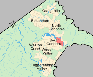
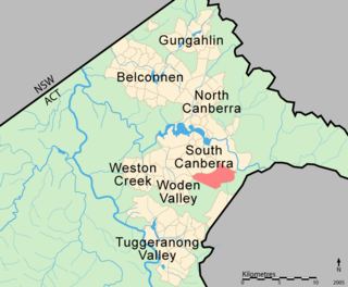
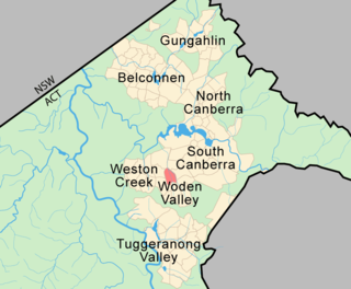
The District of Canberra Central is one of the original eighteen districts of the Australian Capital Territory used in land administration consisting of both the districts of North Canberra and South Canberra. The district is subdivided into divisions (suburbs), sections and blocks. The district of Canberra Central lies entirely within the bounds of the city of Canberra, the capital city of Australia.
Tralee is a future planned suburb of Queanbeyan, New South Wales. It lies south of Jerrabomberra and the site once planned for the future city of Environa. It was named after Tralee in Ireland.

Carwoola is a locality in the state of New South Wales, Australia. It is immediately to the south of the Kowen district, which is located in the Australian Capital Territory. The Molonglo River passes through the Carwoola area before opening out into the Molonglo Plains. The Kings Highway and Captains Flat Road are the two major through routes. Carwoola is part of the Queanbeyan-Palerang Regional Council and the Southern Tablelands geographic area. The area also roughly aligns with the original Carwoola Parish.

The Jerrabomberra District is a district of Canberra. It is situated to the southeast of South Canberra, south of the Molonglo River, east of Woden Valley and north east of Tuggeranong and west of the New South Wales border. It includes the suburbs of Beard, Hume, Oaks Estate and Symonston and the military communications and logistics facility HMAS Harman. At the 2016 census, it had a total population of 1,240, comprising 559 in Symonston, 430 in Hume and 251 in Oaks Estate and Beard At the 2011 census, 13 also lived in Harman. It is named after Jerrabomberra Creek, which runs through it, Jerrabomberra is derived from the Aboriginal word, meaning "afraid of lightning".
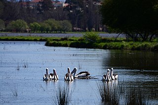
Jerrabomberra Wetlands is one of 13 wetlands locations in the capital state of Australia and forms part of the Molonglo River floodplain. It was artificially formed by the filling of Lake Burley Griffin in 1964. ACT Parks and Conservation manage the wetlands as part of Canberra Nature Park alongside the Woodlands and Wetlands Trust.