
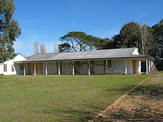
Lanyon is an historic homestead and grazing property located on the southern outskirts of Canberra in the Australian Capital Territory.
Lanyon is an historic homestead and grazing property located on the southern outskirts of Canberra in the Australian Capital Territory.
The site was first occupied following white settlement by Timothy Beard, who depastured cattle on the Limestone Plains as early as 1829. Beard had been transported to Australia for life and arrived in the colony in 1806. After receiving his pardon he entered the pastoral industry as a squatter. Beard's huts were located on the Molonglo River near Queanbeyan and on the site of Lanyon homestead. Beard was forced out of the area by land grants and later became an innkeeper at Bringelly (Moore, 1982).

James Wright and his friend John Hamilton Mortimer Lanyon settled at Lanyon in 1833 as squatters after arriving from London earlier that year. (James also took his wife and his 5 children with him.) In 1835 they purchased several adjoining blocks on the Murrumbidgee River, then the edge of legal occupation within the nineteen counties. Wright and Lanyon established an orchard, vegetable gardens, planted wheat and purchased cattle and sheep and set up a dairy herd. Fifteen convicts were assigned to Wright and Lanyon by 1835, increasing to thirty by 1837. Wright's elder brother William arrived in 1836 and purchased adjoining land. William died in 1837 following a shooting accident. Lanyon returned to England and died in 1841. Wright married Mary Davis in 1838 and the first three of their eight children were born at Lanyon. Wright encountered financial difficulties and was forced to sell Lanyon in 1841 and move to nearby Cuppacumbalong station. The Wrights had established a self-supporting community at Lanyon of up to 60 people. The design of Wright's courtyard buildings is said to be reminiscent of his native Derbyshire (ACT Government, 1994).
Lanyon was next purchased by Andrew Cunningham, a banker from Fyfeshire in Scotland. Cunningham arrived in Sydney with his family in 1845 and settled at Congwarra, north west of Lanyon. The Cunninghams built the present Lanyon homestead from local fieldstone in 1859. Lanyon was carrying 25,000 sheep by the time of Andrew Cunningham's death in 1887 and the Cunninghams had acquired five properties. Cunningham's sons James and Andrew Jackson Cunningham operated the properties in partnership, with James at Tuggeranong and Andrew at Lanyon. In 1905 Andrew Jackson married Louisa Leman and extended and redecorated the homestead. Andrew died in 1913 and Louisa sold the contents of the homestead and returned to Sydney. James Cunningham moved his family from Tuggeranong to Lanyon in 1915.
After James' death in 1921 his son Andy oversaw Lanyon until 1926 when the property was sold to Harry Osborne of Currandooley, near Bungendore. The Osbornes sold the property in 1930 to Thomas Field who had large landholdings in New South Wales and Queensland. The Field family lived in Sydney but visited Lanyon often. They implemented major changes, including modern farming methods, large scale pasture improvement and irrigation of lucerne.
By the late 1960s, the growth of the National Capital had necessitated the resumption of large tracts of farmland south of Canberra. Up to a dozen rural leases, in parts of South Woden and Weston Creek, were resumed to make way for development of Tuggeranong, the second of Canberra's urban satellites [1] Lanyon, was the largest single parcel of freehold land in the ACT. Tom Field lodged plans to sub-divide some of his 9,000 acres (36 km2). When the Federal Government proceeded to acquire Lanyon, Field refused an offer of $1.875m and sought compensation of $33m, the amount a private valuer had placed on the land when assessed at urban values. [2]
The matter of Field versus the Commonwealth of Australia eventually proceeded to Australia’s High Court. The government defended the level of compensation it had offered Mr Field, concerned too that if successful, the ‘Field Case’ would set a dangerous precedent for compensation on freehold land throughout Australia. The Federal Government acquired Lanyon for $3.7m in 1974. [3] In the early to mid-1970s the McMahon and Whitlam Governments withdrew the rural leases for Lanyon, Cuppacumbalong Homestead and Gold Creek Homestead. [4]
The government converted the homestead into the Sidney Nolan Gallery which opened to the public in 1975. [5] It housed a collection of the paintings of Sir Sidney Nolan. A purpose-built gallery for the Nolan collection was built in the grounds in 1980. An extensive conservation and restoration program was undertaken and the homestead is now managed as a house museum, within a working property, by the ACT Government and the National Trust of Australia (ACT).
Lanyon Homestead was threatened by the 2003 Canberra bushfires, which also threatened the nearby township of Tharwa. On 18 January 2003, as fires were approaching Canberra, the homestead was hosting a wedding. The fire situation deteriorated, prompting the evacuation of Tharwa, which was defended and saved by Southern Rural Fire Brigades. The Lanyon Homestead was not impacted by fire, though it did come under ember attack. A single fire truck was on hand to hose down and protect the historic homestead. Given the age of Lanyon, this was certainly not the first time the property had faced bushfires.

The Australian Capital Territory (ACT), known as the Federal Capital Territory (FCT) until 1938, is a federal territory of Australia. Canberra, the capital city of Australia, is situated within the territory, and serves as the territory's primate city. It is located in southeastern Australian mainland as an enclave completely within the state of New South Wales. Founded after Federation as the seat of government for the new nation, the territory hosts the headquarters of all important institutions of the Australian Government.

Monaro Highway is a 285-kilometre-long (177 mi) highway in Victoria, New South Wales, and the Australian Capital Territory, in Australia, linking Cann River in Victoria to Canberra in the Australian Capital Territory (ACT) via the Monaro region. From its southern terminus, it follows the nearby Cann River upstream towards the New South Wales border through heavily forested terrain. Within New South Wales (NSW), it makes its way through further forest before reaching the pastures typical of the Monaro. There are multiple towns and villages along the highway, including Bombala, Nimmitabel, and Cooma. The terrain within the Monaro is largely hilly, and there are numerous crossings. The road also parallels the former Bombala railway line in several locations. Within the ACT, the road becomes a high volume roadway and serves the southern suburbs of Canberra. The highway has more recently had a grade-separated dual carriageway extension constructed within Canberra, as part of the Eastern Parkway construction project. It is designated part of route M23, and route A23 within Canberra, and route B23 within Victoria and New South Wales, with a concurrency where it also carries route B72 between the two sections of Snowy Mountains Highway.

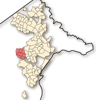
Tuggeranong is a district in the Australian Capital Territory in Australia. The district is subdivided into divisions (suburbs), sections and blocks and is the southernmost district of the Australian Capital Territory. The district comprises nineteen suburbs and occupies 117 square kilometres (45 sq mi) to the east of the Murrumbidgee River.

The 2003 Canberra bushfires caused severe damage to the suburbs and outer areas of Canberra, the capital city of Australia, during 18–22 January 2003. Almost 70% of the Australian Capital Territory's (ACT) pastures, pine plantations, and nature parks were severely damaged, and most of the Mount Stromlo Observatory was destroyed. After burning for a week around the edges of the ACT, the fires entered the suburbs of Canberra on 18 January 2003. Over the next ten hours, four people died, over 490 were injured, and 470 homes were destroyed or severely damaged, requiring a significant relief and reconstruction effort.

Gungahlin is a district in the Australian Capital Territory, one of fastest growing regions in Australia. The district is subdivided into suburbs, sections and blocks. Gungahlin is an Aboriginal word meaning either "white man's house" or "little rocky hill".
Weston Creek is a district in the Australian Capital Territory in Australia. The district is subdivided into divisions (suburbs), sections and blocks. The district comprises eight residential suburbs, situated to the west of the Woden Valley district and approximately 13 kilometres (8.1 mi) southwest of the Canberra City centre. Situated adjacent to the district was the large Stromlo Forest pine plantation until the forest was destroyed by bushfires in 2001 and 2003.
The suburbs of the Australian Capital Territory are organised into a hierarchy of districts, town centres, group centres, local suburbs and other industrial areas and villages. While these divisions have no formal role in the governance or administration of the city, they formed a basis for the planning and development of the city and are significant to the city's commercial and social activities.
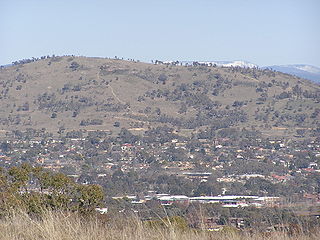
Mount Taylor is a prominent hill with an elevation of 856 metres (2,808 ft) AHD that is located between the Woden Valley, Weston Creek district and Tuggeranong Valley, in Canberra, within the Australian Capital Territory, Australia. Mount Taylor is part of the Canberra Nature Park and is surrounded by the suburbs of Kambah, Fisher, Waramanga, Chifley, Pearce, and Torrens. There are walking tracks to the peak. While there is no public road access to the peak there is a fire trail up the mountain from the end of Waldock St, Chifley where there is also a car park and picnic tables. The fire trail is normally closed to public vehicular access by locked gates, but the gates contain access points for walkers. The trail is especially popular with families and older walkers as it provides the easiest and most leisurely access to the peak. Originally a dirt road, it was partially sealed in 2009 on the steeper grades to make it safer for walkers and mountain bike riders.

Tharwa is a village in the district of Paddys River, in the Australian Capital Territory in Australia. It is situated on the southern side of the Australian Capital Territory, 35 kilometres (22 mi) south of Canberra. At the 2021 census, Tharwa had a population of 82.
The history of the Australian Capital Territory (ACT) as a separate administrative division began in 1911, when it was transferred from New South Wales to the Australian federal government. The territory contains Australia's capital city Canberra and various smaller settlements. Until 1989, it also administered the Jervis Bay Territory, a small coastal region.

Tuggeranong Homestead is located in the Australian Capital Territory in the area now covered by the suburb of Richardson. It is a property of historical significance and is listed on the ACT Heritage Register. It was owned by a succession of prominent pastoralists over the last century before it was resumed by the Government. Today it is used as a venue for special events, conferences and weddings.

Ginninderra is the name of the former agricultural lands surrendered to urban development on the western and north-western fringes of Canberra, the capital of Australia. Ginninderra corresponds with the watershed of Ginninderra Creek, which is now in part occupied by the Canberra districts of Belconnen and Gungahlin.
Gold Creek Homestead is a 140-year-old stone and brick building located off Gungahlin Drive in Ngunnawal a north-western suburb of Canberra, Australia. It is adjacent to the Grove Ngunnawal retirement village currently being developed by Lend Lease.
Cuppacumbalong is an historic homestead located near the southern outskirts of Canberra in the Australian Capital Territory. It is also the name of a former 4,000-acre (16 km2) sheep and cattle grazing property that surrounded the homestead near the junction of the Murrumbidgee and Gudgenby Rivers. The word Cuppacumbalong is Aboriginal in origin and means 'meeting of the waters'. One of the property's early owners Leopold Fane De Salis made a noteworthy contribution to political life during colonial times and furthermore, Cuppacumbalong has strong connections to the life of William Farrer, the father of the Australian wheat industry.

Lambrigg is an historical property close to Tharwa in the Australian Capital Territory which is listed by the ACT Heritage Council as a place of historical significance. It was the residence of William James Farrer who made a major contribution to the wheat industry by developing a strain of wheat that was resistant to wheat rust. Lambrigg was the site where Farrer conducted his work on genetic selection for his wheat varieties.

Tuggeranong Creek, a partly perennial stream of the Murrumbidgee catchment within the Murray–Darling basin, is located in the Tuggeranong district of Canberra, within the Australian Capital Territory, Australia.
The ACT Rural Fire Service is a branch of the Australian Capital Territory Emergency Services Agency. It is responsible for the prevention, detection and extinguishment of all bushfires within the ACT, as well as assisting the other branches of ESA.
Googong Foreshores is a heritage-listed historic precinct at London Bridge Road, Burra, New South Wales, Australia. It consists of the historic surroundings of the Googong Dam that predated the dam itself. It is also known as the Googong Foreshores Cultural and Geodiversity Heritage Areas. It was added to the Australian Commonwealth Heritage List on 3 November 2017.
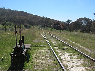
Tuggeranong is a former railway station, sometimes referred to as Tuggeranong Siding or Tuggeranong Platform, that was located on a now-disused portion of the Bombala railway line.