London Circuit

Last updated

London Circuit

Looking northeast on London Circuit.jpg
Looking northeast on London Circuit
General information
TypeRoad
Location Canberra
Length1.86 km (1.2 mi)
Opened1930s
Former
route number
  • Australian Capital Territory Tourist Drive 1.svg ACT Tourist Drive 1
  • (Constitution Avenue–Northbourne Avenue) [Anti-clockwise]
  • Australian Capital Territory Tourist Drive 7.svg ACT Tourist Drive 7
  • (Edinburgh Avenue–Commonwealth Avenue) [Clockwise]
Ring road around City Hill
 
Location(s)
Major suburbs Civic (CBD)

London Circuit is a road in Canberra, Australia, which surrounds City Hill in Civic, the city centre. [1] It has a hexagonal shape, and intersects with several main roads such as Northbourne Avenue ( 35°16′48″S149°07′44″E / 35.28°S 149.129°E / -35.28; 149.129 (London Circuit at Northbourne Avenue) ), Edinburgh Avenue ( 35°16′59″S149°07′34″E / 35.283°S 149.126°E / -35.283; 149.126 (London Circuit at Edinburgh Avenue) ), Akuna Street ( 35°16′55″S149°07′55″E / 35.282°S 149.132°E / -35.282; 149.132 (London Circuit at Akuna Street) ), Constitution Avenue and Commonwealth Avenue ( 35°17′02″S149°07′41″E / 35.284°S 149.128°E / -35.284; 149.128 (London Circuit at Commonwealth Avenue) ).

Several important buildings are located on London Circuit. These include the Australian Capital Territory Legislative Assembly, the Supreme Court, [2] [3] the ACT Magistrates Court, the historic Sydney and Melbourne Buildings, the Canberra Theatre and the QT Canberra.

As part of construction of stage 2A of the Canberra light rail, work will commence in 2022 to raise part of London Circuit by 6 m (20 ft) and provide a signalised, level intersection with Commonwealth Avenue. The ACT Government claim this will create a more "people oriented" space, improving access for pedestrians and cyclists as well as public transport infrastructure, [4] however warned of traffic disruption over a four year period during construction. This intersection is currently grade-separated and makes use of a cloverleaf style ramps, requiring the demolition of the current overpass, to be replaced by new roadway built on top of 60,000 m3 of fill material. Tracks will be laid along the western portion of London Circuit between this new junction and Northbourne Avenue, with a station to be built on this section to serve City West and the Australian National University. A portion of the eastern section of London Circuit between Commonwealth and Constitution Avenues will also be upgraded as part of this project. [5] These works are expected to be completed in 2024. [6] [7]

LondonCircuit1.jpg
London Circuit looking west towards Black Mountain with the Sydney and Melbourne Buildings on the right, office buildings in the distance, and Telstra Tower visible on Black Mountain Civic1.JPG
London Circuit looking west towards Black Mountain with the Sydney and Melbourne Buildings on the right, office buildings in the distance, and Telstra Tower visible on Black Mountain

See also

Australia road sign W5-29.svg Australian Roadsportal

Related Research Articles

<span class="mw-page-title-main">Federal Highway (Australia)</span> Highway in New South Wales and the Australian Capital Territory

Federal Highway is a highway in New South Wales and the Australian Capital Territory. It is a part of a motorway-standard link between Sydney and Canberra, and is also the main thoroughfare between those cities.

<span class="mw-page-title-main">Civic, Australian Capital Territory</span> Suburb of Canberra, Australian Capital Territory

Civic is the city centre or central business district of Canberra. "Civic" is a common name for the district, but it is also called Civic Centre, City Centre, Canberra City and Canberra, and its official division name is City.

<span class="mw-page-title-main">Gungahlin</span> Place in Australian Capital Territory

Gungahlin is a district in the Australian Capital Territory, one of fastest growing regions in Australia. The district is subdivided into suburbs, sections and blocks. Gungahlin is an Aboriginal word meaning either "white man's house" or "little rocky hill".

<span class="mw-page-title-main">Albert Hall, Canberra</span>

The Albert Hall is a hall in Canberra, Australia, used for entertainment. It is on Commonwealth Avenue between Commonwealth Bridge and the Hotel Canberra in the suburb of Yarralumla.

<span class="mw-page-title-main">Lyneham, Australian Capital Territory</span> Suburb of Canberra, Australia

Lyneham is a suburb of Canberra, Australia in the North Canberra district. It is named after Sir William Lyne, premier of New South Wales from 1899 to 1901. The suburb name was gazetted in 1928, but development did not commence until 1958. The streets of Lyneham are named after artists and people associated with the development of early Canberra.

<span class="mw-page-title-main">Parliamentary Triangle, Canberra</span>

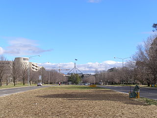
The National Triangle, which is referred to as the Parliamentary Triangle, is the ceremonial precinct of Canberra, containing some of Australia's most significant buildings. The National Triangle is formed by Commonwealth, Kings and Constitution Avenues. Buildings within the National Triangle have been located and designed intentionally for visual effect, and those of national significance are popular tourist attractions.

<span class="mw-page-title-main">Dickson Centre, Australian Capital Territory</span>

The Dickson Centre, located in the suburb of Dickson, is a group centre in the inner northern suburbs of Canberra.

<span class="mw-page-title-main">Northbourne Avenue</span> Road in Canberra, Australia

Northbourne Avenue is a major road in Canberra, Australia. It extends from City Hill in the south, to the Federal Highway in the north.

<span class="mw-page-title-main">City Hill, Canberra</span> Park in Canberra, Australia

City Hill is a park located in Canberra, Australia, on one of the points of the Parliamentary Triangle, a feature of Walter Burley Griffin's plan for the city. The park is surrounded by Vernon Circle, at the south end of Northbourne Avenue, but beyond Vernon Circle it is further surrounded by the concentric London Circuit, and the area between Vernon Circle and London Circuit can also be seen as part of the hill. City Hill is an integral part of the city centre design. To the south of the hill Northbourne Avenue becomes Commonwealth Avenue, and further along is Commonwealth Avenue bridge.

<span class="mw-page-title-main">Commonwealth Avenue (Canberra)</span> Road in Canberra, Australia

Commonwealth Avenue is a major road in Canberra, Australian Capital Territory, Australia. It connects Civic with South Canberra. Specifically, it runs between City Hill and Capital Hill.

<span class="mw-page-title-main">Kings Avenue, Canberra</span> Road in Canberra, Australia

Kings Avenue is a road in Canberra which goes between New Parliament House, across Lake Burley Griffin at the Kings Avenue Bridge, to Russell near the Australian-American Monument..

<span class="mw-page-title-main">Bunda Street</span> Road in Canberra, Australia

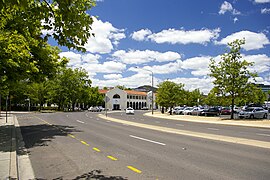
Bunda Street is a shared traffic zone in Canberra, Australia in the Civic shopping area of Civic. It passes between Northbourne Avenue and Glebe Park. A number of cafes and nightclubs are located on the side of the road, such as Gus's cafe in the Garema Centre. The road passes underneath the Canberra Centre, which bridges the road and ends the shared zone.

<span class="mw-page-title-main">Canberra railway station</span> Railway station in Canberra, Australia

Canberra railway station is located on the NSW TrainLink Regional Southern Line in the Australian Capital Territory, Australia. It is located in the Canberra suburb of Kingston.

<span class="mw-page-title-main">City Interchange</span>

City Interchange, formerly City Bus Station is located in the central business district of Canberra. It is a major connecting point for Transport Canberra services across the ACT, as well as commuter bus services to surrounding areas in New South Wales. Bus stands are located on Alinga Street, East Row and Mort Street, while light rail platforms are located in the median on Northbourne Avenue. The Jolimont Centre, which serves as a station for long-distance, interstate coach services is located to the west of Northbourne Avenue, within easy walking distance of all stands and platforms.

<span class="mw-page-title-main">Light rail in Canberra</span> Light rail network in Canberra, Australia

The Canberra light rail network, also known as Canberra Metro, is a light rail system serving the city of Canberra, Australia. The initial 12-kilometre (7.5 mi) line links the northern town centre of Gungahlin to the city centre (Civic) and has 14 stops. Services commenced on 20 April 2019. The 14th stop at Sandford Street in Mitchell commenced operation in September 2021.

<span class="mw-page-title-main">Transport in Canberra</span> Information about transport in Canberra, Australia

Transport in Canberra is provided by private cars, buses, taxis and light rail, while rail, air, and long-distance coach services operate for travel beyond Canberra. A vast road network also plays a major role in transport within and beyond the city.

<span class="mw-page-title-main">Haig Park</span>

Haig Park is a park in the suburbs of Braddon and Turner in Canberra, Australia. It lies on either side of Northbourne Avenue.

<span class="mw-page-title-main">Vernon Circle</span> Road in Canberra, Australia

Vernon Circle is a road in Canberra, Australia that encircles City Hill.

<span class="mw-page-title-main">Reserve Bank of Australia Building, Canberra</span>

The Reserve Bank of Australia Building is a heritage-listed bank building at 20-22 London Circuit, City, Canberra, Australian Capital Territory, Australia. It was designed by Howlett and Bailey in 1962 and built from 1963 to 1965 by Civil & Civic. It was added to the Australian Commonwealth Heritage List on 22 June 2004.

<span class="mw-page-title-main">Commonwealth Avenue Bridge</span> Two parallel bridges that cross Lake Burley Griffin between Parkes and City in Canberra, Australia

The Commonwealth Avenue Bridge are two parallel pre-stressed concrete box girder road bridges that carry Commonwealth Avenue across Lake Burley Griffin, and connect Parkes and City in Canberra, in the Australian Capital Territory, Australia.

References

  1. "Naming The Streets And Public Places: Civic Centre Passes" (scan). The Canberra Times . 16 December 1927. p. 2. Retrieved 18 January 2022 via Trove. On the northern side of the City Commonwealth Avenue terminates at City Square and London Circuit is the name which has been applied to the hexagonal shaped roadway which surrounds City Hill.
  2. "Roving Canberra Around Canberra: A Case Of Destruction and Construction" (scan). The Canberra Times. 18 January 1963. pp. 16, 17. Retrieved 18 January 2022 via Trove.
  3. "Prime Minister Lauds Expansion Of Capital" (scan). The Canberra Times. 9 May 1963. p. 1. Retrieved 18 January 2022 via Trove.
  4. "Revealed: Bridges go to raise London Circuit". Canberra CityNews. 30 October 2021.
  5. Ian Bushnell (3 November 2021). "Raising London Circuit works approvals lodged with National Capital Authority". RiotACT.
  6. "Canberra Light Rail Stage two". Railway Technology. 12 March 2021.
  7. Jordan Hayne (3 February 2021). "Extension of Canberra's light rail, overhauling London Circuit, gets federal environmental approval". Australian Broadcasting Corporation.
Template:Attached KML/London Circuit
KML is from Wikidata