''(Willambeparamal)''"},"photo":{"wt":"Mount Franklin (Victoria).JPG"},"photo_alt":{"wt":"A view of Mount Franklin,Victoria,Australia,an extinct volcano,as seen from the Castlemaine-Daylesford road."},"photo_caption":{"wt":"View from Highway"},"elevation":{"wt":"{{convert|648|m|ft|0}}"},"elevation_ref":{"wt":"{{cite web | url=http://parkweb.vic.gov.au/__data/assets/pdf_file/0017/315530/Heritage-story-Mount-Franklin-Hepburn-Regional-Park.pdf | title=Heritage story - Mount Franklin Hepburn Regional Park | publisher=Parks Victoria | accessdate=2012-04-16 | url-status=dead | archiveurl=https://web.archive.org/web/20120427030507/http://parkweb.vic.gov.au/__data/assets/pdf_file/0017/315530/Heritage-story-Mount-Franklin-Hepburn-Regional-Park.pdf | archivedate=2012-04-27}}"},"prominence_m":{"wt":"270"},"prominence_ref":{"wt":"{{cite web|title=Area around Mount Franklin|url=http://maps.bonzle.com/c/a?a=p&p=36517&sliced=5000&d=ter&s=mount%20franklin&cmd=sp&c=1&x=144%2E14947&y=%2D37%2E26309&w=40000&mpsec=0|publisher=Bonzle Maps of Australia|accessdate=2012-04-24}}"},"location":{"wt":"[[Victoria (Australia)|Victoria]],[[Australia]]"},"map":{"wt":"Australia Victoria"},"range_coordinates":{"wt":""},"map_size":{"wt":"250"},"label_position":{"wt":"right"},"coordinates":{"wt":"{{coord|37.26509|S|144.15043|E|type:mountain_region:AU_scale:50000|format=dms|display=inline,title}}"},"coordinates_ref":{"wt":""},"topo":{"wt":""},"type":{"wt":""},"age":{"wt":""},"first_ascent":{"wt":""},"easiest_route":{"wt":""}},"i":0}}]}" id="mwBw">.mw-parser-output .infobox-subbox{padding:0;border:none;margin:-3px;width:auto;min-width:100%;font-size:100%;clear:none;float:none;background-color:transparent}.mw-parser-output .infobox-3cols-child{margin:auto}.mw-parser-output .infobox .navbar{font-size:100%}body.skin-minerva .mw-parser-output .infobox-header,body.skin-minerva .mw-parser-output .infobox-subheader,body.skin-minerva .mw-parser-output .infobox-above,body.skin-minerva .mw-parser-output .infobox-title,body.skin-minerva .mw-parser-output .infobox-image,body.skin-minerva .mw-parser-output .infobox-full-data,body.skin-minerva .mw-parser-output .infobox-below{text-align:center}@media screen{html.skin-theme-clientpref-night .mw-parser-output .infobox-full-data:not(.notheme)>div:not(.notheme)[style]{background:#1f1f23!important;color:#f8f9fa}}@media screen and (prefers-color-scheme:dark){html.skin-theme-clientpref-os .mw-parser-output .infobox-full-data:not(.notheme) div:not(.notheme){background:#1f1f23!important;color:#f8f9fa}}@media(min-width:640px){body.skin--responsive .mw-parser-output .infobox-table{display:table!important}body.skin--responsive .mw-parser-output .infobox-table>caption{display:table-caption!important}body.skin--responsive .mw-parser-output .infobox-table>tbody{display:table-row-group}body.skin--responsive .mw-parser-output .infobox-table tr{display:table-row!important}body.skin--responsive .mw-parser-output .infobox-table th,body.skin--responsive .mw-parser-output .infobox-table td{padding-left:inherit;padding-right:inherit}}
Mount Franklin (Willambeparamal) | |
---|---|
View from Highway | |
Highest point | |
Elevation | 648 metres (2,126 ft) [1] |
Prominence | 270 m (890 ft) [2] |
Coordinates | 37°15′54″S144°09′02″E / 37.26509°S 144.15043°E |
Geography | |
Mount Franklin (Djadjawurrung: Willambeparamal) is an extinct volcano about 10 km north of Daylesford and 4.6 km south east of Franklinford in Victoria, Australia. [1] A road spirals round the outside slopes covered with pine trees, into a flat 50 acre caldera, and onto the rim which hosts a fire lookout, parking area and picnic ground.
The flat summit area is now used as a free camping ground. A central lawn area is surrounded by a ring of campsites, with picnic tables and wood fire barbecues. There is space for tents, and to park caravans and RVs. A toilet block and water tank (non-potable) is located close to the entrance.
Being a prominent local landmark within Hepburn Shire, the mountain is included within the boundaries of the Mount Franklin Reserve [3] managed by Parks Victoria.
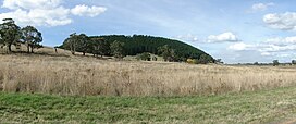
The mountain was created by a volcanic eruption about 470,000 years ago. [4] It is fine example of a breached scoria cone. The breach in the south eastern rim (through which the road now enters) is thought to have been caused by lava flow breaking through the rim. [1] The caldera is one of the deepest in the central highlands area. It is not active. Earlier flows extend to the north and west. The coarse ejecta exposed around the summit includes red and green olivine and megacrysts of high-temperature (some of the largest known Victorian examples) and orthoclase (to 7 cm long) and augite (over 9 cm long). Lumps of Ordovician sedimentary and granitic bedrock also occur in the ejecta and small basalt blocks contain cores of crazed quartz. On the western slope is the parasitic scoria mound known as "Lady Franklin". [5]
The volcanic eruptions may have been witnessed by members of the Dja Dja Wurrung native Aboriginal tribe who called this country the ‘smoking grounds’. The clan that occupied the country around Mount Franklin were the Gunangara Gundidj who called it Willambeparamal meaning home of the emus. [6] [7] Mount Franklin and the surrounding area appears to have been a place of considerable religious significance to Aboriginal people. Both ethnographical and archaeological evidence indicates that frequent large ceremonial gatherings took place in the area. [1] Lava from Mount Franklin and other volcanoes in the area filled valleys and buried the gold bearing streams that became the renowned ‘deep leads’ of the gold mining era. [3]
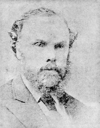
The country around Mount Franklin was described in 1855 as "thickly timbered with box and stringbark". Reports of fertile land waiting to be claimed prompted a minor rush by squatters who called the mount "Jem Crow Hill". [1] Charles Joseph La Trobe, superintendent of the Port Phillip District of New South Wales named the mountain after Sir John Franklin after they climbed the hill together in December 1843. [8] [9] [1]
In 1840, in response to concerns about the treatment of Aboriginal people by the settlers, the government took over Mount Franklin and the surrounding area for the Loddon Aboriginal Protectorate Station. The Protectorate Station was rife with mistreatment of local Aboriginal people. [10]
In 1852, as part of the Victorian gold rush, gold was discovered in the immediate area. This placed additional pressures on the protectorate station and it was reduced and finally relocated. [1]
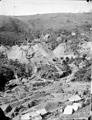
Around 1865 the presence of a deep lead in Mount Franklin was established. Deep lead mining was initially unsuccessful, and it was not until the late 1870s that the Franklinford Gold Mining Company mined at Mount Franklin on a significant scale. A few years later the Mount Franklin Estate Gold Mining Company also struck gold, followed by the Shakespeare and Great Western companies in the mid-1880s. By the late 1880s, however, deep lead mining had ceased in the area.
As the alluvial gold was worked out, miners turned their attention to the gold-bearing leads deep beneath the earth’s surface. This gold was created by lava flows during the Newer Volcanic period, were mined intensively during the nineteenth century. One such company operated a mining lease at the eastern foot of Mount Franklin.
In 1866, the crater of Mount Franklin was set aside as a recreation reserve, and the remainder reserved as State forest. Owing to the high demand for land in the district, two areas of the reserve were excised and sold for agricultural settlement. This galvanised popular support for the permanent reservation of Mount Franklin. [1]
During the 1870s and 80s, scenic qualities of natural bushland gained popularity as recreational venues as compared to formal parks and gardens. In 1875, a meeting asked the Victorian government to reserve all the land at Mount Franklin for public purposes and a reservation of 157 acres was gazetted the following year under shared management of the surrounding local government areas. In 1891 the Shire of Mount Franklin was given sole control of the reserve. [1]
From the 1880s, parts of the reserve were being leased for grazing, providing much-needed revenue for the committee of management. By the 1920s, rabbit infestation was a major problem. Nevertheless, during this period the crater was still a popular destination for picnickers and pleasure-seekers. Mount Franklin was promoted as a local beauty spot within easy reach of Daylesford and Hepburn Springs mineral springs resort. A shelter shed and rainwater tank were erected.
In 1880, the railway network was extended to Daylesford making destinations like Mount Franklin a comfortable day-trip from Melbourne. [1]
In 1944, a devastating bushfire destroyed most of the native vegetation on the mount. As a result, the inner and outer slopes of the crater were planted with exotic species, mainly conifers, to prevent erosion and to provide revenue through commercial harvesting. The caldera was planted with ornamentals such as silver birch, white poplar, Sycamore and Sequoia sempervirens (Californian Redwoods). [1]
Not everyone approved of the scheme. Edgar Morrison remarked on Mount Franklin’s "pine-clad heights": "One feels that when the Forest Commission, a generation ago, draped this foreign garb around its shoulders, the old mount .... resented the indignity." [11]
In 1955, 145 acres was re-reserved as permanent forest under the control of the Shire of Daylesford and Glenlyon. Within the reserve, an area of eight acres was set aside for recreation, specifically for an entrance gate and road which The new road made the mount more accessible at the same time as the dramatic increase in car ownership in the 1950s, and the lifting of war-time petrol rationing.
In 1972, the Department of Crown Lands and Survey took over the committee of management. In 1977, Mount Franklin was included in the new Hepburn Regional Park and managed by the Forest Commission of Victoria.
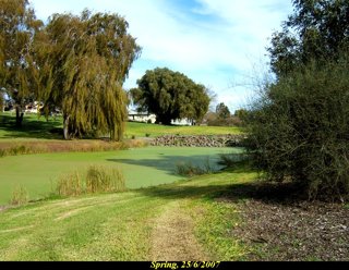
Mineral springs were noted in 1864, when bottling began at Ballan and Hepburn, [12] and their flow rates were recorded during the mid-nineteenth-century gold mining era, [13] and subsequently in 1910. [14] Until 1986, mineral water was bottled by Coca-Cola Amatil from Gilmore's (Limestone Creek) Mineral Spring [12] issuing on allotment No. 3, Section 6, Parish of Yandoit, on a small alluvial flat on the east bank of Limestone Creek located approximately 7 km north of the mount and west of the junction of Limestone Track and Midland Highway.
As noted in a 1910 mineralogy report, "one issue of the spring flowed at a rate of 192 gpd" (726 litres per day), while "other issues could not be measured but altogether they keep filled a water hole about one chain across. The water is palatable but not very strong. Gas is plentiful and may be seen rising in several places. The mineral matter precipitated from spring water covers about an acre around the spring and the water issues through it. It consists of limestone, calcareous sinter quartz, earthy or sandy particles and iron oxide. This deposit is still forming and the surface of the water hole is continuously coated with a dirty white scum. Ordovician rocks outcrop within a few chains of the spring. The more calcareous parts of the spring deposit were formerly burnt for lime and old kilns remain on the flat" [14]
Water Analysis (1950) [14] | parts per million' |
Total dissolved solids (TDS) | 4445 |
Cl | 285 |
CO3 | Nil |
HCO3 | 3004 |
SO4 (sulphate) | 20 |
NO3 (Albuminoid NItrogen) | 0:14 |
NO3 Free (NH3) | 0.84 |
PO4 | n.d. |
K | n.d. |
Na | 615 |
Li | n.d. |
Ca | 208 |
Mg | 194 |
Fe | 49 |
Si03 | n.d. |
Oxygen (30 minutes) | 9 |
Coca Cola, which had a licence to extract 35 megalitres, renamed the spring ‘Mount Franklin’ as part of a re-branding exercise. Their peak per annum extraction was over 15 ML and the total to around 1986 was 14.52 ML. The Mount Franklin trade name remains nationally iconic and profitable for the company, though no water has been extracted from the original site for approximately 35 years. The mineral spring itself was destroyed and the structures have become overgrown and forgotten by the side of the Midland Highway and there is no signage on the site. [15]
While the ‘Mount Franklin’ brand remains under ownership of Coca Cola Amatil, the last water extraction occurred in the fiscal year 1985/1986. [16] and the company's publicity makes no mention of the original spring, nor of the current source or sources of the water bottled under that name. The company continues to extract from the springs in the area including at Eganstown and Wheatsheaf. In 2003 Victorian Water Quality Monitoring Network analyses showed tap waters in Victoria being salted and carbonated and sold as “Mineral Waters” as since the 1990's the Australian Government had deviated from international regulation in this field with respect to consumer protection by deferring to industry self-regulation and obviating a regulatory or welfare approach. Coca-Cola represented Australia. [17]
Castlemaine is a town in west central Victoria, Australia, in the Goldfields region about 120 kilometres northwest by road from Melbourne and about 40 kilometres from the major provincial centre of Bendigo. It is the administrative and economic centre of the Shire of Mount Alexander. The population at the 2021 Census was 7,506. Castlemaine was named by the chief goldfield commissioner, Captain W. Wright, in honour of his Irish uncle, Viscount Castlemaine.
Kingston is a small town and locality of 19.07km2 in the rural Shire of Hepburn in Victoria, Australia, located just off the Midland Highway about 10 kilometres distance from Creswick, and is about 20 km from Daylesford. Kingston's post code is 3364.
Daylesford is a spa town located in the foothills of the Great Dividing Range, within the Shire of Hepburn, Victoria, Australia, approximately 114 kilometres north-west of Melbourne. First established in 1852 as a gold-mining town, today Daylesford has a population of 2,781 as of the 2021 census.
Penshurst is a town in Victoria, Australia. It is in the Shire of Southern Grampians local government area and is located at the foot of Mount Rouse, an extinct volcano. At the 2006 census, Penshurst had a population of 461. Basic facilities include a hospital with an aged care residency and doctor's surgery, a pub, a hall and two schools – one a State school, the other a Catholic school – the State school has 10 students(2020), the Catholic school 26.
The Loddon River, an inland river of the north–central catchment, part of the Murray-Darling basin, is located in the lower Riverina bioregion and Central Highlands and Loddon Mallee regions of the Australian state of Victoria. The headwaters of the Loddon River rise on the northern slopes of the Great Dividing Range east of Daylesford and descend to flow north into the Little Murray River, near Swan Hill. The river is impounded by the Cairn Curran and Laanecoorie reservoirs.
North Central Victoria is a rural region in the Australian state of Victoria. The region lies to the south of the Victorian/New South Wales border as defined by the Murray River, to the southwest of the Hume region, to the west of the Great Dividing Range contained within the Central Highlands and Victorian Alps, to the north of Greater Melbourne, to the northeast of the Wimmera, and to the east of the Mallee region.
Hepburn Springs is a resort town located in the middle of the largest concentration of mineral springs in Australia, situated in Victoria, 48 km northeast of Ballarat. In the 2021 census, Hepburn had a population of 631, and Hepburn Springs had a population of 368. The total population of Hepburn Springs was 928. The town is named after Captain John Hepburn, who was an early squatter in central Victoria. The traditional owners of the land are the Dja Dja Wurrung.
The Hepburn Mineral Springs Reserve is a 30-hectare (74-acre) reserve near Hepburn Springs, Victoria, Australia. It contains several mineral springs that have been used for drinking and bathing since the 1860s. The site is listed on the Victorian Heritage Register and forms part of Hepburn Regional Park.
Campbells Creek is a town in Victoria, Australia.
Glenlyon is a small village in the Shire of Hepburn local government area, Victoria, Australia around 10 km from Daylesford along the Daylesford–Malmsbury Road, and around 101 km from the Melbourne CBD via Kyneton and Malmsbury.
Dja Dja Wurrung, also known as the Djaara or Jajowrong people and Loddon River tribe, are an Aboriginal Australian people who are the traditional owners of lands including the water catchment areas of the Loddon and Avoca rivers in the Bendigo region of central Victoria, Australia. They are part of the Kulin alliance of Aboriginal Victorian peoples. There are 16 clans, which adhere to a patrilineal system. Like other Kulin peoples, there are two moieties: Bunjil the eagle and Waa the crow.
The Blood Hole massacre occurred in what is now the Australian state of Victoria at Middle Creek, 10–11 kilometres (6–7 mi) from Glengower Station between Clunes and Newstead at the end of 1839 or early 1840, killing an unknown number of Aboriginal people from the Grampians district who were on their way home after trading goods for green stone axe blanks that they obtained near what is now Lancefield.
Aboriginal trackers were enlisted by Europeans in the years following British colonisation of Australia, to assist them in exploring the Australian landscape. The excellent tracking skills of these Aboriginal Australians were advantageous to settlers in finding food and water and locating missing persons, capturing bushrangers and dispersing other groups of Indigenous peoples.
Edward Stone Parker (1802–1865) was a Methodist preacher and assistant Protector of Aborigines in the Aboriginal Protectorate established in the Port Phillip District of colonial New South Wales under George Augustus Robinson in 1838. He established and administered the Franklinford Aboriginal Protectorate Station in the territory of the Dja Dja Wurrung people from January 1841 to the end of 1848.
Franklinford is a locality in the Central Highlands of Victoria, Australia, located in the Shire of Hepburn.
Eganstown is a town located in the Shire of Hepburn, Victoria, Australia. At the 2016 census, Eganstown and the surrounding area had a population of 203.
Swiss Italians of Australia are the Italian-speaking Swiss who settled in Australia during the 1850s and 1860s and their descendants who identified as such.
The Wombat State Forest is located 50 kilometres (31 mi) west of Melbourne, Victoria, Australia, between Woodend and Daylesford, at the Great Dividing Range. The forest is approximately 70,000 hectares in size and sits upon Ordovician or Cenozoic sediments. The Bullarook Wombat State Forest was proclaimed in 1871.
The Jim Crow goldfield was part of the Goldfields region of Victoria, Australia, where gold was mined from the mid- to the late-nineteenth century.
Strangways is a locality split between the local government areas of Hepburn Shire and Mount Alexander Shire, in Central Victoria, Australia. It covers an area of 20.105 square kilometres between the townships of Guidford to the east, Newstead to the north-west and Clydesdale to the south.