
The Victorian Alps, also known locally as the High Country, is a large mountain system in the southeastern Australian state of Victoria. Occupying the majority of eastern Victoria, it is the southwestern half of the Australian Alps, the tallest portion of the Great Dividing Range. The Yarra and Dandenong Ranges, both sources of rivers and drinking waters for Melbourne, are branches of the Victorian Alps.

The Strzelecki Ranges is a set of low mountain ridges located in the West Gippsland and South Gippsland regions of the Australian state of Victoria.

Orbost is a historic early settlers town in the Shire of East Gippsland, Victoria, 375 kilometres (233 mi) east of Melbourne and 235 kilometres (146 mi) south of Canberra where the Princes Highway crosses the Snowy River. It is about 16 kilometres (10 mi) from the surf and fishing seaside town of Marlo on the coast of Bass Strait and 217 km drive to Mount Hotham Snow Resort. Orbost is the service centre for the primary industries of beef, dairy cattle and sawmilling. More recently, tourism has become an important and thriving industry, being the major town close to several national parks that are between the east access to either the surf or the snow, including the famous Snowy River National Park, Alpine National Park, Errinundra National Park, Croajingolong National Park and Cape Conran Coastal Park.
East Gippsland is the eastern region of Gippsland, Victoria, Australia covering 31,740 square kilometres (14%) of Victoria. It has a population of 80,114.
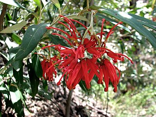
Grevillea victoriae, also known as royal grevillea or mountain grevillea, is a shrub which is endemic to south-eastern New South Wales and mountainous parts of Victoria in Australia.
Mount Disappointment is an 800-metre (2,600 ft) mountain located on the southern end of the Great Dividing Range, 9.5 kilometres (5.9 mi) north of Whittlesea and 60 kilometres (37 mi) north of Melbourne, the state capital of Victoria, Australia. It was named by explorers Hamilton Hume and William Hovell in 1824, and is now a popular hiking spot.
TAFE Gippsland, formerly Advance TAFE & East Gippsland Institute of TAFE is a TAFE institute located in the Gippsland region of Victoria, Australia. It has campuses located at Bairnsdale, Lakes Entrance and Sale as well as specialist education centres located across the south-east of Victoria, encompassing the Wellington Shire and East Gippsland Shire regions.

Grevillea montis-cole is a shrub which is endemic to central-western Victoria, Australia. It has similarities in appearance to Grevillea microstegia, Grevillea floripendula and Grevillea aquifolium but has larger floral bracts. The flowers, which appear between October and March in its native range, have greenish to fawn perianths and red styles.
Nematolepis is a genus of seven species of plants in the family Rutaceae, all endemic to Australia. They are shrubs or small trees with more or less flat leaves arranged alternately and flowers with five overlapping petals and ten stamens. Six species are found in eastern Australia and one in Western Australia.
The Timbarra River is a perennial river of the Mitchell River catchment, located in the East Gippsland region of the Australian state of Victoria.
The Burrinjuck Nature Reserve is a protected nature reserve on the south west slopes of New South Wales, Australia. The 5,250-hectare (13,000-acre) reserve is located adjacent to the Burrinjuck Dam, with 5,118 hectares of the reserve located on the northern side of the reservoir, and the remaining 89 hectares located on the southern side of the reservoir to the northeast of Black Andrew Nature Reserve. It includes land formerly managed as the Burrinjuck State Forest and Burrinjuck State Recreation Area.

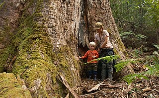
Mount Gibbo is a mountain in the Australian Alps. It is 38 kilometres to the north-east of Benambra in Victoria, Australia and lies within the Mount Gibbo Natural Features and Scenic Reserve managed by Parks Victoria. The reserve, which covers 1493.1 hectares, was established in 1979. On the northern side of the mountain, Ordovician sediments are exposed on the steep slopes. Surrounding peaks include Mount Pinnibar to the north, Mount Hope to the south-east and Mount Sassafras to the west. Plant species found in the reserve include the rare Alpine Phebalium and the endangered Kosciuszko Grevillea. The area was extensively burned by a bushfire in 2003.

Grevillea ramosissima, commonly known as fan grevillea, is a shrub species of the family Proteaceae. It is native to south-eastern Australia.
The Little River is a perennial river of the Snowy River catchment, located in the Alpine region of the Australian state of Victoria. It is one of two rivers of the same name that are tributaries of the Snowy River, the other being the Little River.
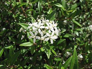
Nematolepis frondosa, commonly known as leafy nematolepis, is a shrub that is endemic to Victoria, Australia. It is a small, conical shaped shrub with glossy leaves, scaly branchlets and white flowers in winter and spring.
Mount Useful is a mountain located to the west of Licola in Victoria, Australia. The summit lies within the Mount Useful Natural Features and Scenic Reserve which was established in 1979 and covers 354 hectares. The mountain has basalt cliffs with columnar jointing on the east and south-east sides.
The Teal Creek, formerly known as Little River, is a perennial stream of the Genoa River catchment, located in the East Gippsland region of the Australian state of Victoria.
The Tanjil River is a perennial river of the West Gippsland catchment, located in the West Gippsland region of the Australian state of Victoria.
The Barkly River, a perennial river of the West Gippsland catchment, is located in the Alpine region of the Australian state of Victoria.
Eastwood, Victoria is a residential suburb of Bairnsdale in the East Gippsland region of Victoria in Australia.
