Pine Mountain (Victoria)

Last updated
Pine Mountain
Looking towards the summit.JPG
Looking towards the summit
Highest point
Coordinates 36°00′54″S147°49′48″E / 36.015°S 147.830°E / -36.015; 147.830 Coordinates: 36°00′54″S147°49′48″E / 36.015°S 147.830°E / -36.015; 147.830
Geography
Australia Victoria Towong Shire location map.svg
Red triangle with thick white border.svg
Pine Mountain
Parent range Great Dividing Range
Western side of Pine Mountain (summit not visible) Western Side of Pine Mountain.jpg
Western side of Pine Mountain (summit not visible)

Pine Mountain is a gigantic monolith, said to be 1.5 times bigger than Uluru, [1] situated in the Burrowa-Pine Mountain National Park in Australia.

Contents

Location

The base of Pine Mountain is located 10 km southeast of the small town of Walwa, Victoria which is a 440 km drive northeast of Melbourne or 115 km east of Albury-Wodonga. The mountain is part of the Burrowa-Pine Mountain National Park which offers a large number of 4wd and walking tracks, waterfalls, picnic and camping areas and numerous lookouts. [2] The park's remote and rugged character is a major attraction for visits and also contains Mount Burowa which is 1300m high. [3]

Geology, flora and fauna

Pine Mountain is argued to be the largest monolith in Australia at 1.5 times bigger than Uluru. [1] The gigantic red granite monolith was uplifted to its present height of 1062 m more than 2 million years ago. [4] Since then erosion has highlighted the steep eastern side, established several creeks, and in the upper area, created small rock pools which contain shrimp and tadpoles despite annual drying, and large granite marbles 2-3.5 m in diameter. [5]

The Mountain offers a diverse range of vegetation types. It is of great botanical significance due to its number of rare and threatened plant species. Over 200 native plants have been identified on the mountain, 19 of which are rare or local to the area. Rare plant species include Pine Mountain Grevillea (Grevillea jephcottii), Fan Grevillea (Grevillea ramosissima), Broad-leafed Hopbush (Dodonaea rhombifoli) and Phantom Wattle (Acacia phasmoides). [6] [7] [8] Other vegetation includes Black Cypress-pines and Kurrajongs which fringe the steep granite outcrops. [2]

Animal life is abundant and varied. Black wallabies, eastern grey kangaroos and wombats, possums and gliders are especially numerous. The lyre bird is rarely seen but often heard. Over 180 species of birds have been recorded in the park. [2] [4]

Walking track

From the west side base there is a walking track which traverses large granite outcrops and leads to the summit of Pine Mountain. Access to the walking track is achieved along a 5 km dry weather only 4WD track from the entrance of the park. The walk is difficult and only suited to experienced bushwalkers with advanced navigational skills and a high level of physical fitness. The walk to the summit is long and extremely strenuous with a number of steep rock climbs and descents, it is advised that only fit persons attempt this walk, and rock climbing skills and experience are advised to complete this walk. The weather is capable of changing very rapidly so it is necessary to be prepared with warm and waterproof clothing, high energy food supplies and sufficient water. The reasonably worn walking track is a 12 km trip, 8 hrs return (or longer, especially if less than perfectly fit or weighed down with equipment). It is marked out with numerous markers on trees and cairns (ducks). The track is sometimes poorly defined so it is necessary that a map and compass is carried, and are used by a properly trained and experienced user. The summit area offers panoramic views of the surrounding Murray River Valleys and the Snowy Mountains, NSW. For the less adventurous there is also a small walk of 2 km, 1hr return, to Rocky Knob. [1] [5]

See also

Related Research Articles

<span class="mw-page-title-main">Wilsons Promontory National Park</span> Protected area in Victoria, Australia

The Wilsons Promontory National Park, commonly known as Wilsons Prom or The Prom, is a national park in the Gippsland region of Victoria, Australia, located approximately 157 kilometres (98 mi) southeast of Melbourne.

<span class="mw-page-title-main">Mount Buffalo National Park</span> Protected area in Victoria, Australia

The Mount Buffalo National Park is a national park in the alpine region of Victoria, Australia. The 31,000-hectare (77,000-acre) national park is located approximately 350 kilometres (220 mi) northeast of Melbourne in the Australian Alps. Within the national park is Mount Buffalo, a moderately high mountain plateau, with an elevation of 1,723 metres (5,653 ft) above sea level.

<span class="mw-page-title-main">Bald Rock National Park</span> Protected area in New South Wales, Australia

Bald Rock National Park is a national park in northern New South Wales, Australia, just north of Tenterfield on the Queensland border. The border passes over the rock on the Western side. On the other side of the border national park continues as the Girraween National Park.

<span class="mw-page-title-main">Oxley Wild Rivers National Park</span> Protected area in New South Wales, Australia

The Oxley Wild Rivers National Park is a protected national park that is located in the Northern Tablelands region of New South Wales, Australia in the Port Macquarie-Hastings City Council and Walcha Shire councils. The 145,223-hectare (358,850-acre) park is situated 445 kilometres (277 mi) north of Sydney and is named in memory of the Australian explorer John Oxley, who passed through the area in 1818 and is one of the largest national parks in New South Wales.

<span class="mw-page-title-main">Royal National Park</span> Protected area in New South Wales, Australia

The Royal National Park is a protected national park that is located in Sutherland Shire in the Australian state of New South Wales, just south of Sydney.

<span class="mw-page-title-main">Uluṟu-Kata Tjuṯa National Park</span> Protected area in the Northern Territory, Australia

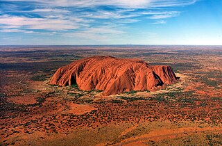
Uluṟu-Kata Tjuṯa National Park is a protected area in the Northern Territory of Australia. The park is home to both Uluru and Kata Tjuta. It is located 1,943 kilometres (1,207 mi) south of Darwin by road and 440 kilometres (270 mi) south-west of Alice Springs along the Stuart and Lasseter Highways. The park covers 1,326 square kilometres (512 sq mi) and includes the features it is named after: Uluru and, 40 kilometres (25 mi) to its west, Kata Tjuta. The location is listed as a UNESCO World Heritage Site for natural and cultural landscape.

<span class="mw-page-title-main">Burrowa-Pine Mountain National Park</span> Protected area in Victoria, Australia

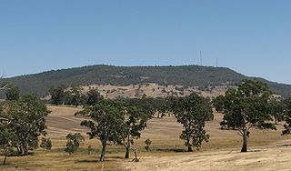
The Burrowa-Pine Mountain National Park is a national park in the Hume region of Victoria, Australia. The 18,400-hectare (45,000-acre) national park is situated approximately 315 kilometres (196 mi) northeast of Melbourne and 120 kilometres (75 mi) east of Albury-Wodonga.

<span class="mw-page-title-main">Girraween National Park</span> Protected area in Queensland, Australia

Girraween National Park is an area of the Granite Belt in the Darling Downs region of Queensland, Australia reserved as a national park. Girraween is known for its spectacular flowers, dramatic landscapes and unique wildlife. Bushwalking and rock climbing are the most popular activities in the park.

<span class="mw-page-title-main">Monolith</span> Stone block made of one single piece; object made of one single rock piece.

A monolith is a geological feature consisting of a single massive stone or rock, such as some mountains. For instance, Savandurga mountain is a monolith mountain in India. Erosion usually exposes the geological formations, which are often made of very hard and solid igneous or metamorphic rock. Some monoliths are volcanic plugs, solidified lava filling the vent of an extinct volcano.

<span class="mw-page-title-main">Mount Bogong</span> Mountain in Victoria, Australia

Mount Bogong,, located in the Alpine National Park and part of the Victorian Alps of the Great Dividing Range, is the highest mountain in Victoria, Australia, at 1,986 metres (6,516 ft) above sea level.

<span class="mw-page-title-main">Mount Alexander</span> Mountain in Victoria, Australia

Mount Alexander is a mountain located approximately 125 km north-west of Melbourne, near the town of Harcourt. It rises 350 metres above the surrounding area to a level of 744 metres above sea level. Being a prominent local landmark, the mountain has its name associated with the surrounding district once known as the Mount Alexander goldfields, and presently defined as the Shire of Mount Alexander, centred on Castlemaine. Most of the mountain is included within the boundaries of the Mount Alexander Regional Park managed by Parks Victoria. The Djadjawurrung name for the mountain is Lanjanuc.

<span class="mw-page-title-main">Walwa, Victoria</span> Town in Victoria, Australia

Walwa, is a town in the Shire of Towong in north east Victoria, Australia. The town is located 1 kilometre from the Murray River on the former Murray Valley highway between Wodonga and Corryong. At the 2016 census, the Walwa population had declined to just 177 having been 268 just ten years earlier.

<i>Grevillea victoriae</i> Species of shrub in the family Proteaceae endemic to New South Wales and Victoria, Australia

Grevillea victoriae, also known as royal grevillea or mountain grevillea, is a shrub which is endemic to south-eastern New South Wales and mountainous parts of Victoria in Australia.

<i>Grevillea burrowa</i> Species of shrub in the family Proteaceae from the north-east of Victoria in Australia

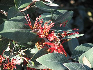
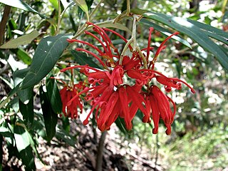
Grevillea burrowa, commonly known as Burrowa grevillea, is a species of flowering plant in the family Proteaceae and is endemic to a restricted area of Victoria, Australia. It is a spreading shrub with oblong to egg-shaped leaves, and clusters of reddish-pink flowers.

<i>Grevillea jephcottii</i> Species of shrub in the family Proteaceae endemic to Victoria, Australia

Grevillea jephcottii, commonly known as Pine Mountain grevillea, green grevillea or Jephcotts grevillea is a species of flowering plant in the family Proteaceae and is endemic to a restricted area of Victoria. It is a low dense, to tall spindly shrub with narrowly oblong to narrowly elliptic leaves, and clusters of pale lemon or greenish flowers with a purplish style.

Mount Selma is a mountain located to the north-east of Aberfeldy in Victoria, Australia. Its peak is 1463 metres above sea level. The headwaters of the Aberfeldy River rise on its southerly slopes.

Mount Kaye is a mountain in the Coopracambra National Park, north of the township of Cann River in East Gippsland in Victoria, Australia.

<span class="mw-page-title-main">Kokerbin Rock</span> Monolith in Western Australia

Kokerbin Rock, also known as Kokerbin Hill, is a granite rock formation located within Kokerbin Nature Reserve in the Wheatbelt region of Western Australia. The area has special significance for the Nyoongar. There are claims that Kokerbin Rock is the third largest monolith in Australia, with Mount Wudinna in South Australia being the second largest and Uluru in the Northern Territory being the largest.

<span class="mw-page-title-main">Toolangi State Forest</span>

The Toolangi State Forest region in southern Australia extends from Mount Monda in the south up to Murrindindi in the north and includes the township of Toolangi. The forest is mainly eucalypt forest that has regrown from the 1939 Victoria Bushfires.

<span class="mw-page-title-main">Mount Augustus (Western Australia)</span> Prominent inselberg in Western Australia

Mount Augustus is located roughly 1,000 km north of Perth, in the Mount Augustus National Park in Western Australia. The name is also given to the neighbouring pastoral lease, Mount Augustus Station. The local Wadjari people call it Burringurrah, after a Dreamtime figure, a young boy who was speared and turned into a rock. It has been a sacred site for thousands of years.

References

  1. 1 2 3 "Visitor Guide" (PDF).
  2. 1 2 3 "Sight on Parks Victoria".
  3. "Archived copy" (PDF). Archived from the original (PDF) on 2012-04-05. Retrieved 2012-12-15.{{cite web}}: CS1 maint: archived copy as title (link)
  4. 1 2 "Burrowa-Pine Mountain National Park, High Country - Explore Australia". Archived from the original on 2017-03-13. Retrieved 2017-03-13.
  5. 1 2 Local Attractions sign located in local park in Walwa
  6. "Burrowa-Pine Mountain National Park Visitor Guide" (PDF). Parks Victoria. Retrieved 15 December 2012.
  7. Australia Government, Australian Botanic National Gardens, Grevillea Jephcottii
  8. "Draft Flora and Fauna Guarantee Action Statement" (PDF).