
Moogerah Peaks is a National Park in the Fassifern Valley of South East Queensland, Australia, located approximately 70 km south west of the state capital Brisbane. The 676-hectare park consists of four separate protected areas which surround volcanic peaks and rocky cliffs near Moogerah Dam.

The Springbrook National Park is a protected national park that is located in the Gold Coast hinterland of Queensland, Australia. The 6,197-hectare (15,310-acre) park is situated on the McPherson Range, near Springbrook, approximately 100 kilometres (62 mi) south of Brisbane. The park is part of the Shield Volcano Group of the UNESCO World Heritage–listed Gondwana Rainforests of Australia.

Mount Wellington, officially Kunanyi / Mount Wellington, is a mountain in the southeast of Tasmania, Australia. It is the summit of the Wellington Range and is within Wellington Park reserve. Hobart, Tasmania's capital city, is located at the foot of the mountain.

The Dandenong Ranges are a set of low mountain ranges, rising to 633 metres at Mount Dandenong, approximately 35 km (22 mi) east of Melbourne, Victoria, Australia. The ranges consist mostly of rolling hills, steeply weathered valleys and gullies covered in thick temperate rainforest, predominantly of tall mountain ash trees and dense ferny undergrowth.

Mount Canobolas, a mountain on a spur of the Great Dividing Range, is located in the Central Tablelands region of New South Wales, Australia.

Tongariro National Park is the oldest national park in New Zealand, located in the central North Island. It has been acknowledged by UNESCO as a World Heritage Site of mixed cultural and natural values.
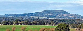
Mount Buninyong is an extinct volcano in western Victoria, Australia rising to 745 metres (2,444 ft) AHD. It lies within the Mount Buninyong Scenic Reserve, 4 kilometres (2.5 mi) north of the town of Buninyong and 14 kilometres (8.7 mi) south of Ballarat, on the regional city's rural-urban fringe.
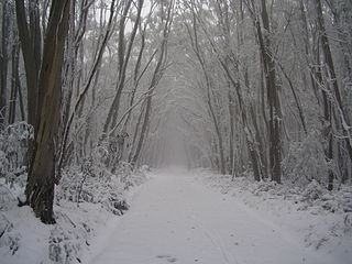
Lake Mountain is a 1,433-metre-high (4,701 ft) mountain peak on a plateau that hosts a cross-country ski resort that is known by the same name. It is located in Victoria, Australia, approximately 120 kilometres (75 mi) north-east of Melbourne. The 1,483-metre-high (4,865 ft) Mount Bullfight, which is within the Mount Bullfight Nature Conservation Reserve, is the highest peak that can be reached by a ski trail. Access to Lake Mountain's summit itself is restricted to a snow shoe track in winter. Lake Mountain is the most popular ski resort in Australia in terms of total visitor numbers, including sightseers, due to its proximity to Melbourne.
ȽÁU,WELṈEW̱/John Dean Provincial Park, formerly John Dean Provincial Park, is a small, densely vegetated provincial park on the Saanich Peninsula of southern Vancouver Island, British Columbia, Canada. The park is located on and around ȽÁU,WELṈEW̱, a small mountain in the traditional territory of Wsanec First Nations, itself situated 20 km north of Victoria, the provincial capital city.

Mount Torbreck is a mountain in Victoria, Australia 150 km from Melbourne. The mountain was listed as a place that could be declared as an alpine resort in The Alpine Resorts Act 1983, however no resort was ever developed on the site and it was recommended to be changed to a natural and scenic features reserve in 1994.

Mount Grace State Forest is a publicly owned forest with recreational features located in the town of Warwick. The state forest centers around Mount Grace, which at 1,621 feet (494 m) is the third highest point in Massachusetts east of the Connecticut River after Mount Wachusett and Mount Watatic. It is bordered by portions of Warwick State Forest to the east and west and is managed by the Massachusetts Department of Conservation and Recreation.
Mount Buller is a mountain in the Victorian Alps of the Great Dividing Range, located in the Australian state of Victoria. It has an elevation of 1,805 metres (5,922 ft) AHD,
Mount Grace, 1,617 feet (493 m), is a prominent monadnock located in north central Massachusetts in the town of Warwick, approximately two miles south of the New Hampshire border. The mountain is rugged and largely wooded, but a firetower on the summit provides expansive views of the surrounding rural countryside. Little Mount Grace, 1,226 feet (374 m), is the southern summit of the mountain. Mount Grace supports a predominantly northern hardwood forest as well as stands of red spruce near its summit.

Mount Macedon is a dormant volcano that is part of the Macedon Ranges of the Great Dividing Range, located in the Central Highlands region of Victoria, Australia. The mountain has an elevation of 1,001 metres (3,284 ft) with a prominence of 643 metres (2,110 ft) and is located approximately 65 kilometres (40 mi) northwest of Melbourne.

Mount Ginini is a mountain with an elevation of 1,762 metres (5,781 ft) AHD in the Brindabella Ranges that is located on the border between the Australian Capital Territory and New South Wales in Australia.
Alander Mountain is a 2,241-foot-tall (683 m) prominent peak of the south Taconic Mountains; it is located in southwest Massachusetts and adjacent New York. Part of the summit is grassy and open and part is covered with scrub oak and shrubs; the sides of the mountain are wooded with northern hardwood tree species. Views from the top include the southern Taconic Mountains, the Hudson River Valley including the Catskills. Several trails traverse Alander Mountain, most notably the 15.7 mi (25.3 km) South Taconic Trail, which passes just beneath the summit.

Mount William is a mountain of the Grampians Mountain Range, located within the Grampians National Park, in the Australian state of Victoria. The mountain is situated approximately 250 kilometres (160 mi) west-northwest of Melbourne on the eastern edge of the national park, approximately 22 kilometres (14 mi) drive from Halls Gap.

Mount Terrible is a mountain within the Great Dividing Range, located to the south-west of Kevington in Victoria, Australia. The mountain is located within the 100 hectares Mount Terrible Natural Features and Scenic Reserve.

Mount Gibbo is a mountain in the Australian Alps. It is 38 kilometres to the north-east of Benambra in Victoria, Australia and lies within the Mount Gibbo Natural Features and Scenic Reserve managed by Parks Victoria. The reserve, which covers 1493.1 hectares, was established in 1979. On the northern side of the mountain, Ordovician sediments are exposed on the steep slopes. Surrounding peaks include Mount Pinnibar to the north, Mount Hope to the south-east and Mount Sassafras to the west. Plant species found in the reserve include the rare Alpine Phebalium and the endangered Kosciuszko Grevillea. The area was extensively burned by a bushfire in 2003.

The Dutchmans Stern Conservation Park is a protected area located in South Australia about 5 kilometres north-west of the town of Quorn in the Flinders Ranges. It includes a mountain known as The Dutchmans Stern from which its name is derived.
