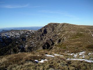
The Alpine National Park is a national park located in the Central Highlands and Alpine regions of Victoria, Australia. The 646,000-hectare (1,600,000-acre) national park is located northeast of Melbourne. It is the largest National Park in Victoria, and covers much of the higher areas of the Great Dividing Range in Victoria, including Victoria's highest point, Mount Bogong at 1,986 metres (6,516 ft) and the associated subalpine woodland and grassland of the Bogong High Plains. The park's north-eastern boundary is along the border with New South Wales, where it abuts the Kosciuszko National Park. On 7 November 2008 the Alpine National Park was added to the Australian National Heritage List as one of eleven areas constituting the Australian Alps National Parks and Reserves.

The Mount Buffalo National Park is a national park in the alpine region of Victoria, Australia. The 31,000-hectare (77,000-acre) national park is located approximately 350 kilometres (220 mi) northeast of Melbourne in the Australian Alps. Within the national park is Mount Buffalo, a moderately high mountain plateau, with an elevation of 1,723 metres (5,653 ft) above sea level.

The Baw Baw National Park is a national park located on the boundary between the Victorian Alps and Gippsland regions of Victoria, Australia. The 13,530-hectare (33,400-acre) national park is situated approximately 120 kilometres (75 mi) east of Melbourne and 50 kilometres (31 mi) north of the Latrobe Valley. The park contains the forest covered Baw-Baw Plateau and surrounds the Mount Baw Baw Alpine Resort.
Mount Baw Baw is a mountain summit on the Baw-Baw Plateau of the Great Dividing Range, located in Victoria, Australia. The name is from the Woiwurrung language spoken by Eastern Kulin people. It is of uncertain meaning, but possibly signifies, echo, or ghost.

Mount Hotham is a mountain located in the Victorian Alps of the Great Dividing Range, in the Australian state of Victoria. The mountain is located approximately 357 kilometres (222 mi) north east of Melbourne, 746 kilometres (464 mi) from Sydney, and 997 kilometres (620 mi) from Adelaide by road. The nearest major road to the mountain is the Great Alpine Road. The mountain is named after Charles Hotham, Governor of Victoria from 1854 to 1855.
Mount Buffalo is a mountain plateau of the Australian Alps and is within the Mount Buffalo National Park in Victoria, Australia. It is located approximately 350 kilometres (220 mi) northeast of Melbourne. It is noted for its dramatic scenery.

Mount St Gwinear is a mountain in Victoria, Australia, located at the north-east end of the Baw Baw National Park in the Gippsland high country. It is popular with families looking for a cheap and accessible snow-play/tobogganing destination and cross-country skiers. The Baw Baw Plateau provides an abundance of easy touring terrain. Mount Baw Baw downhill ski village is approximately 9 km away across the Baw Baw plateau to the south-west and trails link the resorts.

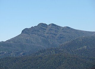
Mount Stirling is a mountain in the Victorian Alps of the Great Dividing Range, located in the Hume region of Victoria, Australia. The mountain has an elevation of 1,747–1,749 metres (5,732–5,738 ft) above sea level.
Lake Mountain is a 1,433-metre-high (4,701 ft) mountain peak on a plateau that hosts a cross-country ski resort that is known by the same name. It is located in Victoria, Australia, approximately 120 kilometres (75 mi) north-east of Melbourne. The 1,483-metre-high (4,865 ft) Mount Bullfight, which is within the Mount Bullfight Nature Conservation Reserve, is the highest peak that can be reached by a cross-country ski trail from Lake Mountain. Access to Lake Mountain's summit is restricted to a snow shoe track in winter. The Lake Mountain Alpine Resort, located near Lake Mountain, is the most popular ski resort in Australia when measured in terms of total visitor numbers, including sightseers, due to its proximity to Melbourne.
Mount Buller is a mountain in the Victorian Alps of the Great Dividing Range, located in the Australian state of Victoria. It has an elevation of 1,805 metres (5,922 ft) AHD,
Mount Buggery is a mountain located in the Alpine Shire within the Alpine National Park in the alpine region of Victoria, Australia. The mountain is located on the end of a ridgeline known as the Crosscut Saw between Mount Speculation and Mount Howitt, both located 4 kilometres (2.5 mi) to the south of Mount Buggery.

The Horn is the most prominent peak on the Mount Buffalo plateau in Victoria, Australia. The Horn has an elevation of 1,723 metres (5,653 ft) AHD.
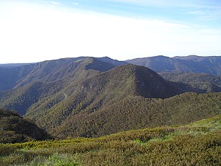
The Cobberas Range, a mountain range that is part of the Great Dividing Range within the Victorian Alps, is located in north-eastern Victoria in Australia. The range is located in the Cobberas Wilderness area of the Alpine National Park.
Mount Wellington is a mountain located to the north-east of Licola in Victoria, Australia. It is on the border of the Alpine National Park and Avon Wilderness Park. The Avon River rises on its south-eastern slopes.
Mount Cobbler is a mountain located in the Alpine National Park to the east of Mansfield in north-eastern Victoria, Australia. Its summit rises to 1,628 metres (5,341 ft) above sea level. The peak and surrounding Cobbler land system are composed of sedimentary rocks, dating to the Lower Carboniferous period, some 359 to 318 million years ago.

Mount Gibbo is a mountain in the Australian Alps. It is 38 kilometres to the north-east of Benambra in Victoria, Australia and lies within the Mount Gibbo Natural Features and Scenic Reserve managed by Parks Victoria. The reserve, which covers 1493.1 hectares, was established in 1979. On the northern side of the mountain, Ordovician sediments are exposed on the steep slopes. Surrounding peaks include Mount Pinnibar to the north, Mount Hope to the south-east and Mount Sassafras to the west. Plant species found in the reserve include the rare Alpine Phebalium and the endangered Kosciuszko Grevillea. The area was extensively burned by a bushfire in 2003.
The Deddick River is a perennial river of the Snowy River catchment, located in the Alpine region of the Australian state of Victoria.
Mount Selwyn is a mountain that is part of the Victorian Alps of the Great Dividing Range, located in the Alpine National Park in the Australian state of Victoria. Mount Selwyn has an altitude of 1,411 metres (4,629 ft) AHD.
Mount Buggery is a mountain located in the Wangaratta Rural City local government area, near Abbeyard above the Buffalo River in the alpine region of Victoria, Australia.
Mount Despair is a mountain, part of the Cobbler Plateau, that is located in the Alpine Shire within the Alpine National Park in the alpine region of Victoria, Australia.
