
The Mount Buffalo National Park is a national park located in the alpine region of Victoria, Australia. The 31,000-hectare (77,000-acre) national park is located approximately 350 kilometres (220 mi) northeast of Melbourne in the Australian Alps. Within the national park is Mount Buffalo, a moderately high mountain plateau, with an elevation of 1,723 metres (5,653 ft) above sea level.

The Baw Baw National Park is a national park located on the boundary between the Victorian Alps and Gippsland regions of Victoria, Australia. The 13,530-hectare (33,400-acre) national park is situated approximately 120 kilometres (75 mi) east of Melbourne and 50 kilometres (31 mi) north of the Latrobe Valley. The park contains the forest covered Baw-Baw Plateau and surrounds the Mount Baw Baw Alpine Resort.

The Victorian Alps, also known locally as the High Country, is a large mountain system in the southeastern Australian state of Victoria. Occupying the majority of eastern Victoria, it is the southwestern half of the Australian Alps, the tallest portion of the Great Dividing Range. The Yarra and Dandenong Ranges, both sources of rivers and drinking waters for Melbourne, are branches of the Victorian Alps.

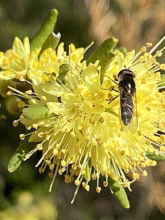
Grevillea aquifolium is a shrubby or scrambling plant endemic to South Australia and Victoria. Common names include holly grevillea, prickly grevillea or variable prickly grevillea. It occurs naturally in woodland, open forest and heathland.
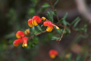
The Australian flowering shrub Grevillea alpina has several common names, including mountain grevillea, alpine grevillea, and cat's claws. It is not limited to alpine environments, and in fact is less common at high elevation than low. The species is variable in appearance, with five general forms described: small-flowered, Grampians, Northern Victorian, Goldfields, and Southern Hills forms. It is found in dry forests and woodlands across Victoria and into southern New South Wales. Some forms of the plant are low to the ground, and some become a spreading shrub. The flowers come in many colours, from white to green to shades of red and pink, or a pattern of several colours. The curled flowers are 1 to 3 centimetres in length. It is attractive to nectar-feeding insects and birds.
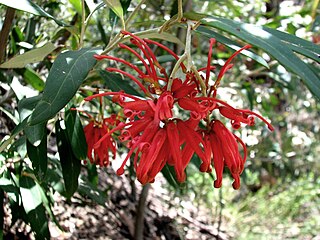
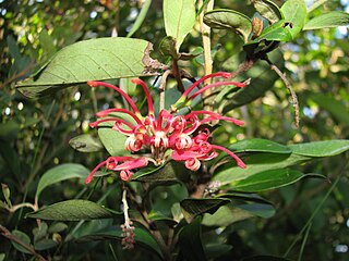
Grevillea victoriae, also known as royal grevillea or mountain grevillea, is a shrub which is endemic to south-eastern New South Wales and mountainous parts of Victoria in Australia.

Grevillea montis-cole is a shrub which is endemic to central-western Victoria, Australia. It has similarities in appearance to Grevillea microstegia, Grevillea floripendula and Grevillea aquifolium but has larger floral bracts. The flowers, which appear between October and March in its native range, have greenish to fawn perianths and red styles.
The Timbarra River is a perennial river of the Mitchell River catchment, located in the East Gippsland region of the Australian state of Victoria.
Grevillea miqueliana, commonly known as oval-leaf grevillea, is a shrub that is endemic to mountainous areas of eastern Victoria in Australia. It grows to between 1.5 and 2.5 metres in height. The species was first formally described by botanist Ferdinand von Mueller, his description published in Transactions of the Philosophical Society of Victoria in 1855. The species epithet honours Dutch botanist Friedrich Anton Wilhelm Miquel (1811-1871).
The Cobberas Range, a mountain range that is part of the Great Dividing Range within the Victorian Alps, is located in north-eastern Victoria in Australia. The range is located in the Cobberas Wilderness area of the Alpine National Park.

Mount Terrible is a mountain within the Great Dividing Range, located to the south-west of Kevington in Victoria, Australia. The mountain is located within the 100 hectares Mount Terrible Natural Features and Scenic Reserve.
Mount Selma is a mountain located to the north-east of Aberfeldy in Victoria, Australia. Its peak is 1463 metres above sea level. The headwaters of the Aberfeldy River rise on its southerly slopes.
Leionema phylicifolium, commonly known as alpine phebalium, is a shrub that is endemic to south-eastern Australia. It is a small shrub with green, smooth, leathery leaves and pale yellow flowers in spring.
Mount Elizabeth is a mountain to the east of Tambo Crossing in East Gippsland, Victoria, Australia. It lies within the Mount Elizabeth Nature Conservation Reserve managed by Parks Victoria. The reserve, which covers 5,234 hectares, was established in 1984. The reserve is the only known location where the endangered plant species leafy nematolepis occurs. Other rare or vulnerable plant species found in the reserve include Tullach Ard grevillea, outcrop guinea-flower, Mount Elizabeth hovea, monkey mint-bush and leafless pink-bells. Fauna species of note include the lace monitor, yellow-tailed black cockatoo and gang-gang cockatoo.
Mount Bulla Bulla is a mountain in the of the Victorian Alps in the Great Dividing Range. It is located within the Alpine National Park, in the Australian state of Victoria. The name Bulla Bulla was the original indigenous name for Mt Buller.

Grevillea ramosissima, commonly known as fan grevillea, is a shrub species of the family Proteaceae. It is native to south-eastern Australia.
Mount Useful is a mountain located to the west of Licola in Victoria, Australia. The summit lies within the Mount Useful Natural Features and Scenic Reserve which was established in 1979 and covers 354 hectares. The mountain has basalt cliffs with columnar jointing on the east and south-east sides.
Mount Kaye is a mountain in the Coopracambra National Park, north of the township of Cann River in East Gippsland in Victoria, Australia.

The Toolangi State Forest region in southern Australia extends from Mount Monda in the south up to Murrindindi in the north and includes the township of Toolangi. The forest is mainly eucalypt forest that has regrown from the 1939 Victoria Bushfires.
The Gibbo River, a perennial river of the North-East Murray catchment of the Murray-Darling basin, is located in the alpine and East Gippsland regions of Victoria, Australia. It flows from the northwestern slopes of the Australian Alps, south and joins with Morass Creek southeast of Lake Dartmouth.

