
Stirling Range National Park is a national park in the Great Southern region of Western Australia, approximately 337 kilometres (209 mi) south-east of Perth.
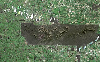
The Stirling Range or Koikyennuruff is a range of mountains and hills in the Great Southern region of Western Australia, 337 kilometres (209 mi) south-east of Perth. It is over 60 kilometres (37 mi) wide from west to east, stretching from the highway between Mount Barker and Cranbrook eastward past Gnowangerup. The Stirling Range is protected by the Stirling Range National Park, which was gazetted in 1913, and has an area of 1,159 km2 (447 sq mi).

The Jardine River, formally known as Deception River, is the largest river of the Cape York Peninsula in Far North Queensland, Australia.
The Hann River is a river in the Kimberley region of Western Australia.

The Chamberlain River is a river in the Kimberley region of Western Australia.
The Adcock River is a river in the Kimberley region of Western Australia.

The Oakover River is a river in the Pilbara region of Western Australia.
Ardyaloon or One Arm Point, also known as Bardi, is an Aboriginal Australian community town on the Dampier Peninsula, in the Kimberley region of Western Australia. It is located 2,446 km (1,520 mi) north of Perth and the closest populated town is Derby. At the 2016 census, Bardi had a population of 365.

The Prince Regent River is a river in the Kimberley region of Western Australia.

The Carson River is a river in the Kimberley region of Western Australia.
The Yule River is an ephemeral river in the Pilbara region of Western Australia. It was named on 10 August 1861 by the surveyor and explorer Frank Gregory while on expedition in the area, after Thomas Newte Yule, at times farmer of Toodyay, winemaker, Acting Colonial Secretary and Magistrate.
The Coongan River is an ephemeral river in the Pilbara region of Western Australia.
The Wilson River is a river in the Kimberley region of Western Australia.
The Minilya River is a river in the Gascoyne region of Western Australia.

The Barnett River is a river in the Kimberley region of Western Australia.
The Walker River is a river in the Northern Territory, Australia.
The Robinson River is a river in Australia's Northern Territory.
The Jackey Jackey Creek, also often called Jacky Jacky Creek, is a creek in the Cape York Peninsula region of Far North Queensland, Australia.
The Kendall River is a river in Far North Queensland, Australia.

