Related Research Articles
Mount Barney National Park is a national park in Queensland (Australia), 90 km southwest of Brisbane. It amalgamated the adjacent Mount Lindesay National Park in 1980. It is part of the Scenic Rim Important Bird Area, identified as such by BirdLife International because of its importance in the conservation of several species of threatened birds.
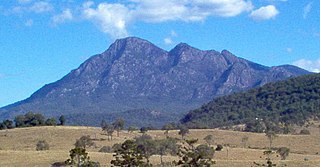
Mount Barney is a mountain within the Scenic Rim Region in south-east Queensland, Australia. It lies approximately 130 kilometres (81 mi) south-west of Brisbane, not far from the Queensland - New South Wales border, and forms part of the McPherson Range. It is a popular destination for bushwalkers and campers. Mount Barney is the sixth or seventh highest mountain in Queensland and is often regarded as one of the most impressive parts of the Scenic Rim. The mountain consists of two main peaks,, and smaller subsidiary peaks. East Peak is probably the most popular destination for bushwalkers.
Mount Lindesay is a rural locality in the Scenic Rim Region, Queensland, Australia. It borders New South Wales. In the 2021 census, Mount Lindesay had a population of 14 people.

The Narrow Neck Plateau, an eroded remnant of a sandstone layer situated at an elevation of 1,000 metres (3,300 ft) above sea level that is part of the Blue Mountains Range which is a spur line off the Great Dividing Range, is situated immediately south-west of Katoomba in New South Wales, Australia, located within the Blue Mountains National Park. The neck separates the Jamison Valley from the Megalong Valley.

The Arthur Range is a mountain range in the South West Wilderness, located in south-west Tasmania, Australia. The range is broken into two main sections, the Western Arthurs and the Eastern Arthurs. Both sections of the range are popular overnight bushwalking destinations, generally in summer.

Ninderry is a rural town and locality in the Sunshine Coast Region, Queensland, Australia. In the 2021 census, the locality of Ninderry had a population of 1,301 people.

Mount York, a mountain in the western region of the Explorer Range, part of the Blue Mountains Range that is a spur off the Great Dividing Range, is located approximately 150 kilometres (93 mi) west of Sydney, just outside Mount Victoria in New South Wales, Australia. Mount York has an elevation of 1,061 metres (3,481 ft) AHD and is a projection of the Blue Mountains dissected plateau, creating a promontory of the western escarpment with a minor rise at its summit.

The Scenic Rim Region is a local government area in West Moreton region of South East Queensland, Australia. Also, is southern part of the Brisbane. Established in 2008, it was preceded by several previous local government areas with histories extending back to the early 1900s and beyond. The main town of the region is Beaudesert.

The Scott Glacier is a major glacier, 120 nautical miles long, that drains the East Antarctic Ice Sheet through the Queen Maud Mountains to the Ross Ice Shelf. The Scott Glacier is one of a series of major glaciers flowing across the Transantarctic Mountains, with the Amundsen Glacier to the west and the Leverett and Reedy glaciers to the east.

Mount Tate is a prominent rocky mountain on the Main Range of the Snowy Mountains located in southeastern New South Wales, Australia.

Carruthers Peak, formerly Curruthers Peak, a mountain in the Main Range of the Great Dividing Range, is located in Snowy Mountains region in southeast New South Wales, Australia. The peak is situated between Mount Lee and Mount Twynam within the Kosciuszko National Park.
The Cambanoora Gorge runs between the source of the Condamine River and the town of Killarney in Queensland, Australia. It is not officially named and is also known as the Condamine Gorge and the 14 River Crossings.

Mount Hay, a mountain that is part of the Mt Hay Range of the Blue Mountains Range which is a spur off the Great Dividing Range, is located in the Blue Mountains National Park, New South Wales, Australia. It is located approximately 100 kilometres (62 mi) west of Sydney and 10 kilometres (6.2 mi) north of the nearest town, Wentworth Falls. Mount Hay is approximately 944 metres (3,097 ft) AMSL and is one of several basalt caps located within the UNESCO World Heritage Greater Blue Mountains Area.
Tobins River, a perennial stream of the Hastings River catchment, is located in the Northern Tablelands and Mid North Coast districts of New South Wales, Australia.
Mount Asplenium is a mountain in the Main Range of south-east Queensland, Australia. It is protected within the Main Range National Park. The summit can be reached by hiking south from Mount Huntley, however there is no marked trail so only experienced navigators should attempt the ascent. The summit is rocky and covered in rainforest vegetation, making camping unpleasant and blocking out views. Nearby Panorama point, to the south, offers better views and is suitable for camping for a small party.
The Kanangra Creek, a perennial stream of the Hawkesbury-Nepean catchment, is located in the Blue Mountains region of New South Wales, Australia.

Barney View is a rural locality in the Scenic Rim Region, Queensland, Australia. In the 2021 census, Barney View had a population of 38 people.

Mount French is a rural locality in the Scenic Rim Region, Queensland, Australia. In the 2021 census, Mount French had a population of 105 people.

Emu Vale is a rural town and locality in the Southern Downs Region, Queensland, Australia. In the 2021 census, the locality of Emu Vale had a population of 161 people.
The Head is a rural locality in the Southern Downs Region, Queensland, Australia. It borders New South Wales. In the 2021 census, The Head had a population of 12 people.