Queensland is the second largest state in Australia. It contains 472 separate protected areas with a total land area of 69,388 km2 (26,791 sq mi). 223 of these are National parks, which is the highest number of any Australian state or territory, totalling 65,871 km2 (25,433 sq mi). Seven others are Scientific National Parks, totalling 522 km2 (202 sq mi).

Black Mountain (Kalkajaka) National Park is a 781 hectare protected area in Shire of Cook, Queensland, Australia.

Burleigh Head is a small national park at Burleigh Heads in the City of Gold Coast in South East Queensland, Australia.

Davies Creek National Park is in Far North Queensland, Australia, 1,392 km northwest of Brisbane, 20 km south west of Cairns. The park is located on the Atherton Tableland within the Barron River water catchment. It lies within the Einasleigh Uplands and Wet Tropics of Queensland bioregions.

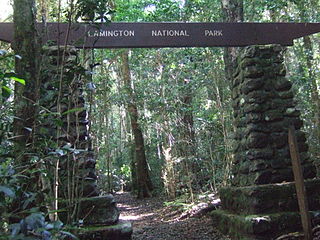
The Lamington National Park is a national park, lying on the Lamington Plateau of the McPherson Range on the Queensland/New South Wales border in Australia. From Southport on the Gold Coast the park is 85 kilometres (53 mi) to the southwest and Brisbane is 110 kilometres (68 mi) north. The 20,600 hectares Lamington National Park is known for its natural environment, rainforests, birdlife, ancient trees, waterfalls, walking tracks and mountain views.

The Springbrook National Park is a protected national park that is located in the Gold Coast hinterland of Queensland, Australia. The 6,197-hectare (15,310-acre) park is situated on the McPherson Range, near Springbrook, approximately 100 kilometres (62 mi) south of Brisbane. The park is part of the Shield Volcano Group of the UNESCO World Heritage–listed Gondwana Rainforests of Australia.

Tamborine is a national park in the Gold Coast hinterland and is a part of the Scenic Rim Regional Council of South East Queensland, Australia, 45 km (28 mi) south of Brisbane.

Mount Tibrogargan is a hill in the Glass House Mountains National Park, north-northwest of Brisbane, Australia. It is a volcanic plug of hard alkali rhyolite that squeezed up into the vents of an ancient volcano 27 million years ago.

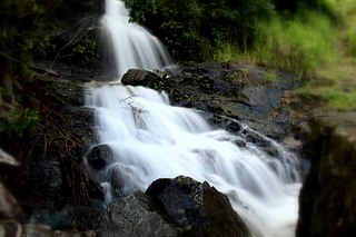
The Davies Creek Falls is a cascade waterfall on the Davies Creek in the Far North region of Queensland, Australia.

Mount Bowen is a mountain located on Hinchinbrook Island, off the north east coast of Queensland, Australia. It rises 1,121 metres (3,678 ft) out of the Coral Sea.

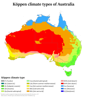
Australia's climate is governed mostly by its size and by the hot, sinking air of the subtropical high pressure belt. This moves north and south with the seasons. The climate is variable, with frequent droughts lasting several seasons, thought to be caused in part by the El Niño-Southern Oscillation. Australia has a wide variety of climates due to its large geographical size. The largest part of Australia is desert or semi-arid. Only the south-east and south-west corners have a temperate climate and moderately fertile soil. The northern part of the country has a tropical climate, varying between tropical rainforests, grasslands and desert.

Moonie is a rural town in the Western Downs Region and a locality split between the Western Downs Region and the Goondiwindi Region in Queensland, Australia. At the 2016 Census, Moonie had a population of 189.

The Glass House Mountains are a cluster of thirteen hills that rise abruptly from the coastal plain on the Sunshine Coast, Queensland, Australia. The highest hill is Mount Beerwah at 556 metres above sea level, but the most identifiable of all the hills is Mount Tibrogargan which from certain angles bears a resemblance to a face staring east towards the ocean. The Glass House Mountains are located near Beerburrum State Forest and Steve Irwin Way. From Brisbane, the mountains can be reached by following the Bruce Highway north and taking the Glass House Mountains tourist drive turn-off onto Steve Irwin Way. The trip is about one hour from Brisbane. The Volcanic peaks of the Glass House Mountains rise dramatically from the surrounding Sunshine Coast landscape. They were formed by intrusive plugs, remnants of volcanic activity that occurred 26-27 million years ago. Molten rock filled small vents or intruded as bodies beneath the surface and solidified into land rocks. Millions of years of erosion have removed the surrounding exteriors of volcanic cores and softer sandstone rock.

The Elabana Falls is a cascade waterfall that is located within Lamington National Park in the South East region of Queensland, Australia.

The Wooroonooran Important Bird Area comprises some 5125 km2 of mainly forested land in the Wet Tropics of Queensland World Heritage Site, of Far North Queensland, Australia.

Mount Sheridan is a suburb of Cairns in the Cairns Region, Queensland, Australia.

Lamb Range is a locality in the Cairns Region, Queensland, Australia. In the 2016 census, Lamb Range had a population of 0.

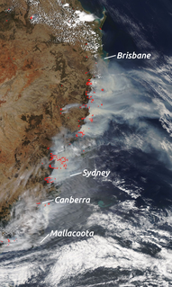
Since June 2019, there have been many large bushfires burning across Australia, especially in the south east where a state of emergency was declared in New South Wales. As of 14 January 2020, fires this season have burnt an estimated 18.6 million hectares, destroyed over 5,900 buildings and killed at least 30 people. An estimated one billion animals were also killed and some endangered species may be driven to extinction.

Mount Cook is a mountain located on Magnetic Island within the Magnetic Island National Park, off the north east coast of Queensland, Australia. Mount Cook rises 493 metres (1,617 ft) out of the Coral Sea and is the highest point on the Magnetic Island.

Devils Thumb, also known as Manjal Jimalji by the Eastern Kuku Yalanji, is a mountain located near Mossman within the Daintree National Park, Far North Queensland, Australia. Devils Thumb rises 1,065 metres (3,494 ft) above sea level. There is a difficult 10.6 kilometre return trail to the peak which takes approximately eight hours.


