
Cape Arid National Park is a national park located in Western Australia, 731 kilometres (454 mi) southeast of Perth. The park is situated 120 kilometres (75 mi) east of Esperance and lies on the shore of the south coast from the eastern end of the Recherche Archipelago.

Fitzgerald River National Park is a national park in the Shires of Ravensthorpe and the Shire of Jerramungup in Western Australia, 419 kilometres (260 mi) southeast of Perth. The park is recognised on Australia's National Heritage List for its outstanding diversity of native plant species, including many plants which are unique to the local area. Although the park only occupies 0.2 percent of Western Australia's land surface, it is home to over 20% of the state's native plant species.

Stirling Range National Park is a national park in the Great Southern region of Western Australia, approximately 337 kilometres (209 mi) south-east of Perth.
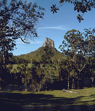
Glass House Mountains National Park is a heritage-listed national park at Glass House Mountains, Sunshine Coast Region, Queensland, Australia. It is also known as Beerburrum Forest Reserve 1. It is 70 km (43 mi) north of Brisbane and consists of a flat plain punctuated by rhyolite and trachyte volcanic plugs, the cores of extinct volcanoes that formed 26 million to 27 million years ago. The mountains would once have had pyroclastic exteriors, but these have eroded away.

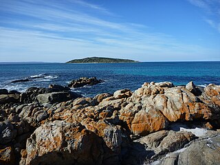
Flinders Island, the largest island in the Furneaux Group, is a 1,367-square-kilometre (528 sq mi) island in the Bass Strait, northeast of the island of Tasmania. Today Flinders Island is part of the state of Tasmania, Australia. It is 54 kilometres (34 mi) from Cape Portland and is located on 40° south, a zone known as the Roaring Forties.

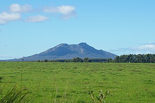
The You Yangs are a series of granite ridges that rise up to 319 m (1,047 ft) above the flat and low-lying Werribee Plain in southern Victoria, Australia, approximately 5 km (3.1 mi) due west of the rural town of Little River, 55 km (34 mi) southwest of Melbourne CBD and 22 km (14 mi) north of Geelong. The main ridge runs roughly north-south for about 9 km (5.6 mi), with a lower extension running for about 15 km (9.3 mi) to the west. Much of the southern parts of the ranges are protected by the You Yangs Regional Park.

Gulf St Vincent, sometimes referred to as St Vincent Gulf, St Vincent's Gulf or Gulf of St Vincent, is the eastern of two large inlets of water on the southern coast of Australia, in the state of South Australia, the other being the larger Spencer Gulf, from which it is separated by Yorke Peninsula. On its eastern side the gulf is bordered by the Adelaide Plains and the Fleurieu Peninsula.
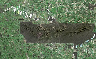
The Stirling Range or Koikyennuruff is a range of mountains and hills in the Great Southern region of Western Australia, 337 kilometres (209 mi) south-east of Perth. It is over 60 kilometres (37 mi) wide from west to east, stretching from the highway between Mount Barker and Cranbrook eastward past Gnowangerup. The Stirling Range is protected by the Stirling Range National Park, which was gazetted in 1913, and has an area of 1,159 km2 (447 sq mi).

Mount Lofty is the highest point in the southern Mount Lofty Ranges. It is located about 15 km (9.3 mi) east of the Adelaide city centre, within the Cleland National Park in the Adelaide Hills area of South Australia.

Adenanthos is a genus of Australian native shrubs in the flowering plant family Proteaceae. Variable in habit and leaf shape, it is the only genus in the family where solitary flowers are the norm. It was discovered in 1791, and formally published by Jacques Labillardière in 1805. The type species is Adenanthos cuneatus, and 33 species are recognised. The genus is placed in subfamily Proteoideae, and is held to be most closely related to several South African genera.

Banksia coccinea, commonly known as the scarlet banksia, waratah banksia or Albany banksia, is an erect shrub or small tree in the family Proteaceae. Its distribution in the wild is along the southwest coast of Western Australia, from Denmark to the Stokes National Park, and north to the Stirling Range, growing on white or grey sand in shrubland, heath or open woodland. Reaching up to 8 m (26 ft) in height, it is a single-stemmed plant that has oblong leaves, which are 3–9 cm (1.2–3.5 in) long and 2–7 cm (0.8–2.8 in) wide. The prominent red and white flower spikes appear mainly in the spring. As they age they develop small follicles that store seeds until opened by fire. Though widely occurring, it is highly sensitive to dieback and large populations of plants have succumbed to the disease.

West Mount Barren is part of the Fitzgerald River National Park located between Bremer Bay and Hopetoun on the south coast of Western Australia the coordinates of the summit of West Mount Barren are 34°12′59″S119°25′58″E.
Mount Manypeaks is a distinctive peak located approximately 35 kilometres (22 mi) north-east of Albany, 10 kilometres (6 mi) north-east of Two Peoples Bay and 6 kilometres (4 mi) south-east of the town of Manypeaks, in Western Australia. Mount Manypeaks Nature Reserve lies to the south of the peak, extending along the coast.
Cape Riche is a cape in the Great Southern region of Western Australia. By road, it is 525 km south-east of Perth and 123 km north-east of Albany. It is part of the locality of Wellstead and is 24 km south of the townsite.
Adenanthos macropodianus, commonly known as gland flower, or Kangaroo Island gland flower, is a species of shrub in the family Proteaceae. It is endemic to Kangaroo Island in South Australia. First published as a variety of A. sericeus in 1870, it was promoted to species rank in 1978.
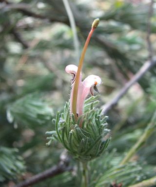
Adenanthos dobagii, commonly known as Fitzgerald woollybush, is a shrub in the family Proteaceae. It grows to a mere 50 cm high, with crowded small silvery leaves and insignificant pink or cream flowers. It occurs only in southwestern Australia, where it is found in Fitzgerald River National Park on the south coast.
Adenanthos labillardierei is a species of erect shrub endemic to the slopes of the Barren Ranges in the Fitzgerald River National Park in southwest Western Australia.

Adenanthos oreophilus, commonly known as woollybush, is a species of tall shrub endemic to southwest Western Australia. It is closely related to the better known A. sericeus, and was only classified as a species distinct from the latter in 1978 by Irish botanist E. Charles Nelson.

The ecology of Sydney, located in the state of New South Wales, Australia, is diverse for its size, where it would mainly feature biomes such as grassy woodlands or savannas and some sclerophyll forests, with some pockets of mallee shrublands, riparian forests, heathlands, and wetlands, in addition to small temperate and subtropical rainforest fragments.


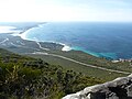 View east from summit
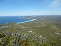 View west from summit
