The Kosciuszko National Park is a 6,900-square-kilometre (2,700 sq mi) national park and contains mainland Australia's highest peak, Mount Kosciuszko, for which it is named, and Cabramurra, the highest town in Australia. Its borders contain a mix of rugged mountains and wilderness, characterised by an alpine climate, which makes it popular with recreational skiers and bushwalkers.

Brockman National Park is a national park in the South West region of Western Australia, 288 kilometres (179 mi) south of Perth and 10 km (6.2 mi) south of Pemberton.

Cape Arid National Park is a national park located in Western Australia, 731 kilometres (454 mi) southeast of Perth. The park is situated 120 kilometres (75 mi) east of Esperance and lies on the shore of the south coast from the eastern end of the Recherche Archipelago.

Cape Le Grand National Park is a national park in Western Australia, 631 km (392 mi) south-east of Perth and 56 km (35 mi) east of Esperance. The park covers an area of 31,801 hectares The area is an ancient landscape which has been above sea level for well over 200 million years and remained unglaciated. As a result, the area is home to many primitive relict species. Established in 1966, the park is managed by the Department of Parks and Wildlife. The name Le Grand is from one of the officers on L'Espérance, one of the ships in the 1792 expedition of Bruni d'Entrecasteaux.

Frank Hann National Park is a national park in Western Australia, located 428 kilometres (266 mi) east-southeast of the capital, Perth in the Shire of Lake Grace. It was named for Frank Hann, an early explorer of the district. The park contains a wide array of flora, including seasonal wildflowers.
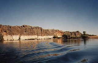
Danggu (Geikie) Gorge National Park is a national park in the Kimberley region of Western Australia, 1,837 kilometres (1,141 mi) northeast of Perth and approximately 420 km (261 mi) east of Broome by road.

Greenmount National Park is a national park in the locality of Greenmount, Western Australia, 22 km east of Perth.

Kennedy Range National Park is a national park in Gascoyne region of Western Australia, approximately 830 kilometres (520 mi) north of Perth and about 150 km (93 mi) east of Carnarvon.

The Mundy Regional Park is a regional park located on the western edge of the Darling Scarp, approximately 22 kilometres (14 mi) east of Perth in Western Australia. The 56-hectare (140-acre) park has commanding views of the Swan Coastal Plain, the city of Perth and surrounding suburbs. The park is managed by the Department of Biodiversity, Conservation and Attractions.

Mount Frankland National Park is a national park in the South West region of Western Australia, 327 km (203 mi) south of Perth. The park is part of the larger Walpole Wilderness Area that was established in 2004, an international biodiversity hotspot.
Neerabup National Park is a national park in the City of Wanneroo in Western Australia, situated approximately 27 kilometres (17 mi) north of Perth.

Porongurup National Park is a national park in the Great Southern region of Western Australia. It covers 26.21 square kilometres (10.12 sq mi), and is 360 kilometres (220 mi) southeast of Perth and 40 kilometres (25 mi) north of Albany.

Karlamilyi National Park lies in the Pilbara region of Western Australia, 250 kilometres (160 mi) northeast of Newman and 1,250 kilometres (780 mi) north-northeast of Perth. Proclaimed an A Class Reserve on 13 April 1977, it is the largest national park in Western Australia.

Stokes National Park is a national park in the Goldfields-Esperance region of Western Australia, 538 km south-east of Perth. The National Park is located 80 kilometres (50 mi) west of Esperance on the southern coast.

Esperance Plains, also known as Eyre Botanical District, is a biogeographic region in southern Western Australia on the south coast between the Avon Wheatbelt and Hampton bioregions, and bordered to the north by the Mallee region. It is a plain punctuated by granite and quartz outcrops and ranges, with a semi-arid Mediterranean climate and vegetation consisting mostly of mallee-heath and proteaceous scrub. About half of the region has been cleared for intensive agriculture. Recognised as a bioregion under the Interim Biogeographic Regionalisation for Australia (IBRA), it was first defined by John Stanley Beard in 1980.

Woody Island is an island off the south coast in the Goldfields-Esperance region of Western Australia.
The south coast of Western Australia comprises the Western Australian coastline from Cape Leeuwin to Eucla. This is a distance of approximately 1,600 kilometres (1,000 mi), fronting the Great Australian Bight and the Southern Ocean.

Considered the biggest rock in the world, Mount Augustus is located roughly 1,000 km north of Perth, in the Mount Augustus National Park in Western Australia. The name is also given to the neighbouring pastoral lease, Mount Augustus Station. The local Wadjari people call it Burringurrah, after a Dreamtime figure, a young boy who was speared and turned into a rock. It has been a sacred site for thousands of years.
The Department of Parks and Wildlife (DPaW) was the department of the Government of Western Australia responsible for managing lands described in the Conservation and Land Management Act 1984 and implementing the state's conservation and environment legislation and regulations. The minister responsible for the department was the Minister for the Environment.
Hopkins Creek Conservation Park is a protected area located in the Australian state of South Australia in the locality of Emu Downs about 125 kilometres (78 mi) north-east of the state capital of Adelaide and about 21 kilometres (13 mi) south of the town of Burra.


