
Fitzgerald River National Park is a national park in the Shires of Ravensthorpe and the Jerramungup in Western Australia, 419 kilometres (260 mi) southeast of Perth. The park is recognised on Australia's National Heritage List for its outstanding diversity of native plant species, including many plants which are unique to the local area.
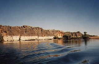
Danggu (Geikie) Gorge National Park is a national park in the Kimberley region of Western Australia, 1,837 kilometres (1,141 mi) northeast of Perth and approximately 420 km (261 mi) east of Broome by road. The gorge was originally named in honour of Sir Archibald Geikie, the Director General of Geological Survey for Great Britain and Ireland when it was given its European name in 1883. Geikie never visited the gorge and the National Park is progressively being officially changed to the Bunuba – the traditional owners of the area – name of Danggu. It is part of the Balili Conservation Park.
Hassell National Park is a national park in the Great Southern region of Western Australia, 367 kilometres (228 mi) southeast of Perth and 57 km (35 mi) north east of Albany.
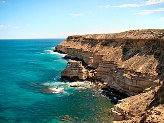
Kalbarri National Park is located 485 km (301 mi) north of Perth, in the Mid West region of Western Australia.

Mount Augustus National Park is located 852 km north of Perth, 490 km by road east of Carnarvon and 390 km northwest of Meekatharra, in the Gascoyne region of Western Australia. Mount Augustus itself, the feature around which the national park is based, is known as Burringurrah to the local Wadjari Aboriginal people.
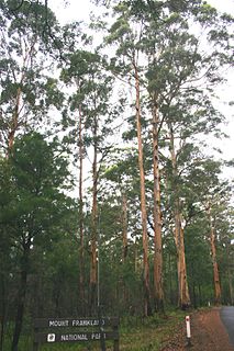
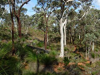
Mount Frankland National Park is a national park in the South West region of Western Australia, 327 km (203 mi) south of Perth. The park is part of the larger Walpole Wilderness Area that was established in 2004, an international biodiversity hotspot.

Peak Charles National Park is a national park in Western Australia, 507 kilometres (315 mi) east of Perth and 170 km (110 mi) north west of Esperance.

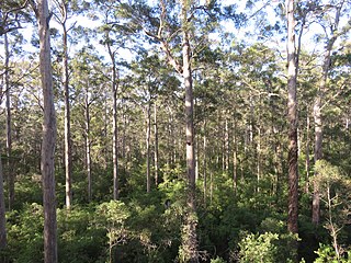
Shannon National Park is a national park on the south coast of Western Australia, 302 km (188 mi) south of Perth and 55 km (34 mi) southeast of Manjimup. It was declared a national park in 1988. The park covers the entire Shannon River basin. It is part of the larger Walpole Wilderness Area that was established in 2004, an international biodiversity hotspot.

Stirling Range National Park is a national park in the Great Southern region of Western Australia, approximately 337 kilometres (209 mi) south-east of Perth.

Torndirrup National Park is a national park in the Great Southern region of Western Australia, 400 kilometres (249 mi) southeast of Perth and via Frenchman Bay Road is 10 km (6.2 mi) south of Albany.
Warren National Park is a national park in the South West region of Western Australia, 287 km (178 mi) south of Perth and 15 km (9.3 mi) south of Pemberton.

Windjana Gorge National Park is a national park in the Kimberley region of Western Australia, 1855 km northeast of Perth and 355 km east of Broome. It is open during the dry season only, usually April to November.

The Gloucester Tree is a giant karri tree in the Gloucester National Park of Western Australia.

Pemberton is a town in the South West region of Western Australia, named after original settler Pemberton Walcott.

The Diamond Tree is a giant karri tree located 10 km south of Manjimup, Western Australia on the South Western Highway.
Beelu National Park is a national park east of Perth, Western Australia. Lying south of Mundaring, Western Australia, and west of the Mundaring Weir Road, it is part of the group of parks known as the Parks of the Darling Range. The park was formerly named Mundaring National Park.

The Dave Evans Bicentennial Tree, a 75 m (246 ft) tall karri tree, was pegged for climbing to celebrate Australia's bicentenary in 1988. It is in Warren National Park in southwestern Australia. Although it has been used as a fire lookout, it is used mainly as a tourist attraction. The lookout platform is reached by climbing 165 metal spikes hammered into the trunk.

Gull Rock National Park is a small national park situated 25 km (16 mi) east of Albany in Western Australia. It was established in 2006, becoming Western Australia's 97th national park in the process. It is around 2,593 hectares in area.

A lookout tree is a simple fire lookout tower created by attaching a ladder or a series of spikes to a tall straight tree with a view of the surrounding lands, allowing rangers or fire crews to conveniently climb the tree to survey their surroundings. The simplest kind consist only of a ladder to a suitable height: this kind was called a "ladder tree." Some ladder trees had platforms on the ground next to them for maps and a fire finder. A more elaborate version often created a platform on top of the tree trunk by cutting off approximately the last 10 feet (3.0 m) of the treetop and building a railed wooden platform on the resulting stump. These "platform trees" were often equipped with telephones, fire finder tables, seats and guy wires. Accommodation for the watcher was provided by a tent or shelter at the bottom of the tree.


