
The Carnarvon xeric shrublands is a deserts and xeric shrublands ecoregion of Western Australia. The ecoregion is coterminous with the Carnarvon Interim Biogeographic Regionalisation for Australia (IBRA) bioregion.

Southwest Australia is a biogeographic region in Western Australia. It includes the Mediterranean-climate area of southwestern Australia, which is home to a diverse and distinctive flora and fauna.

The Murchison is an interim Australian bioregion located within the Mid West of Western Australia. The bioregion is loosely related to the catchment area of the Murchison River and has an area of 281,205 square kilometres (108,574 sq mi). Traditionally the region is known as The Murchison.

The South Western Slopes, also known as the South West Slopes, is a region predominantly in New South Wales, Australia. It covers the lower inland slopes of the Great Dividing Range, extending from north of Dunedoo through central NSW and into northeast Victoria, meeting its southwestern end around Beechworth. More than 90% of the region is in the state of New South Wales and it occupies about 10% of that state.

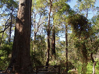
Warren, also known as Karri Forest Region and the Jarrah-Karri forest and shrublands ecoregion, is a biogeographic region in southern Western Australia. Located in the southwest corner of Western Australia between Cape Naturaliste and Albany, it is bordered to the north and east by the Jarrah Forest region. Its defining characteristic is an extensive tall forest of Eucalyptus diversicolor (karri). This occurs on dissected, hilly ground, with a moderately wet climate. Karri is a valuable timber and much of the karri forest has been logged over, but less than a third has been cleared for agriculture. Recognised as a region under the Interim Biogeographic Regionalisation for Australia (IBRA), and as a terrestrial ecoregion by the World Wide Fund for Nature, it was first defined by Ludwig Diels in 1906.

Lane Poole Reserve is a protected area in Western Australia. It is located at the edge of the Darling Scarp, in the former town of Nanga Brook, just over 100 kilometres (62 mi) southeast of Perth.

The Avon Wheatbelt is a bioregion in Western Australia. It has an area of 9,517,104 hectares. It is considered part of the larger Southwest Australia savanna ecoregion.

Hampton is an interim Australian bioregion located in southeastern coastal Western Australia, with a small portion (4%) extending into adjacent South Australia. It has an area of 1,088,198 hectares. The Hampton bioregion is part of the Coolgardie woodlands ecoregion.
Jarrah Forest, also known as the Southwest Australia woodlands, is an interim Australian bioregion and ecoregion located in the south west of Western Australia. The name of the bioregion refers to the region's dominant plant community, jarrah forest – a tall, open forest in which the dominant overstory tree is jarrah.

Yalgoo is an interim Australian bioregion located in Western Australia. It has an area of 5,087,577 hectares. The bioregion, together with the Avon Wheatbelt and Geraldton Sandplains bioregions, is part of the larger Southwest Australia savanna ecoregion as classified by the World Wildlife Fund.
Korung National Park is a national park in Western Australia. It is located 26 kilometres south-east of Perth, on edge of Darling Scarp overlooking the Swan Coastal Plain.

The Walpole Wilderness Area is a group of conservation reserves on the south coast of Western Australia. The area includes vast tracts of jarrah, red tingle and karri forests surrounding granite peaks, rivers, heathlands, and wetlands. Coastal features include inlets and sandy beaches, sheer cliffs and the Southern Ocean.

The Coolgardie woodlands is an ecoregion in southern Western Australia. The predominant vegetation is woodlands and mallee scrub. The ecoregion is a transitional zone between the Mediterranean-climate forests, woodlands, and shrublands of Southwest Australia and the deserts and dry scrublands of the Australian interior.
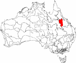
The Desert Uplands is an interim Australian bioregion located in north and central western Queensland which straddles the Great Dividing Range between Blackall and Pentland.

The Pilbara shrublands is a deserts and xeric shrublands ecoregion in Western Australia. It is coterminous with the Pilbara IBRA region. For other definitions and uses of "Pilbara region" see Pilbara.
Mount Roe National Park is a national park in the Great Southern Region of Western Australia. It was designated in 2004, and covers an area of 1278 km2.
Mount Frankland North National Park is a national park in the South West Region of Western Australia. It was designated in 2004, and covers an area of 220.69 km2. It is part of the larger Walpole Wilderness Area that was established in the same year.

Mount Frankland South National Park is a national park in Western Australia. It lies mostly in the South West Region, with the eastern portion in Great Southern Region. It was designated in 2004, and covers an area of 422.99 km2. It is part of the larger Walpole Wilderness Area that was established in the same year.
Blackwood River National Park is a national park in Western Australia. It extends along the middle reach of the Blackwood River, the largest river in South West Australia. It is located in the shires of Augusta–Margaret River and Nannup in the South West region. It was designated in 2004, and covers an area of 204.75 km2.

Gawler is an interim Australian bioregion located in South Australia. It has an area of 12,002,883 hectares. Gawler bioregion is part of the Tirari–Sturt stony desert ecoregion.
