
The Swan River is a major river in the southwest of Western Australia. The river runs through the metropolitan area of Perth, Western Australia's capital and largest city.

Gooseberry Hill National Park is a national park in Western Australia, in the locality of Gooseberry Hill, 21 kilometres (13 mi) east of the Perth central business district. It is at the southern side of the mouth of the Helena Valley on the Darling Scarp. Statham's Quarry is located within the park boundary.

Greenmount National Park is a national park in the locality of Greenmount, Western Australia, 22 km east of Perth.

John Forrest National Park is a national park in the Darling Scarp, 24 km (15 mi) east of Perth, Western Australia. Proclaimed as a national park in November 1900, it was the first national park in Western Australia.
Kalamunda National Park is a national park in Western Australia, 23 kilometres (14 mi) east of Perth, near the town of Kalamunda.

The Mundy Regional Park is a regional park located on the western edge of the Darling Scarp, approximately 22 kilometres (14 mi) east of Perth in Western Australia. The 56-hectare (140-acre) park has commanding views of the Swan Coastal Plain, the city of Perth and surrounding suburbs. The park is managed by the Department of Biodiversity, Conservation and Attractions.

The Darling Scarp, also referred to as the Darling Range or Darling Ranges, is a low escarpment running north–south to the east of the Swan Coastal Plain and Perth, Western Australia. The escarpment extends generally north of Bindoon, to the south of Pemberton. The adjacent Darling Plateau goes easterly to include Mount Bakewell near York and Mount Saddleback near Boddington. It was named after the Governor of New South Wales, Lieutenant-General Ralph Darling.

Upper Swan is an outer suburb of Perth, Western Australia, located 33 kilometres (21 mi) north-east of Perth's central business district in the City of Swan. The locality sits at the confluence of the Swan River, the Millendon Junction to Narngulu railway line and Great Northern Highway, which is where the main suburban townsite is located. The rest of the locality is characterised by rural and industrial land uses such as vineyards, equestrian estates and quarries.

The Kalamunda Zig Zag was a zig zag rail line that was part of the Upper Darling Range railway line in Western Australia, opening in July 1891 and closing in July 1949. Most of it was converted to a public road in 1952, part of which is now a tourist drive called Zig Zag Scenic Drive that offers views of Perth from the hills.

The Swan Coastal Plain in Western Australia is the geographic feature which contains the Swan River as it travels west to the Indian Ocean. The coastal plain continues well beyond the boundaries of the Swan River and its tributaries, as a geological and biological zone, one of Western Australia's Interim Biogeographic Regionalisation for Australia regions. It is also one of the distinct physiographic provinces of the larger West Australian Shield division.

Pickering Brook is a suburb of Perth, Western Australia, located within the City of Kalamunda.
Jane Brook is the name of a watercourse and the valley that passes through the Darling Scarp, and which was utilised for the Eastern Railway and subsequently a central part of the John Forrest National Park.

Lane Poole Reserve is a protected area in Western Australia. It is located at the edge of the Darling Scarp, just over 100 kilometres (62 mi) southeast of Perth. The former town of Nanga Brook is situated within it.

The Avon Wheatbelt is a bioregion in Western Australia. It has an area of 9,517,104 hectares. It is considered part of the larger Southwest Australia savanna ecoregion.
Coolgardie is an Australian bioregion consisting of an area of low hills and plains of infertile sandy soil in Western Australia. It has an area of 129,122.09 square kilometres (49,854.32 sq mi). It includes much of the Great Western Woodlands.

Hampton is an interim Australian bioregion located in southeastern coastal Western Australia, with a small portion (4%) extending into adjacent South Australia. It has an area of 1,088,198 hectares. The Hampton bioregion is part of the Coolgardie woodlands ecoregion.
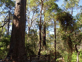
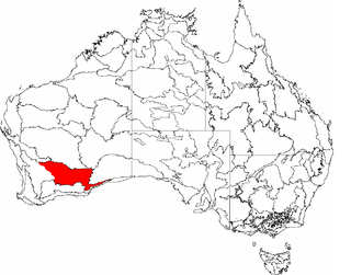
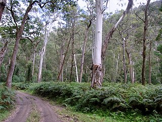
Jarrah Forest, also known as the Southwest Australia woodlands, is an interim Australian bioregion and ecoregion located in the south west of Western Australia. The name of the bioregion refers to the region's dominant plant community, jarrah forest – a tall, open forest in which the dominant overstory tree is jarrah.

The Coolgardie woodlands is an ecoregion in southern Western Australia. The predominant vegetation is woodlands and mallee scrub. The ecoregion is a transitional zone between the Mediterranean-climate forests, woodlands, and shrublands of Southwest Australia and the deserts and dry scrublands of the Australian interior.
Tourist Drives in Western Australia are routes through areas of scenic or historic significance, designated by route markers with white numbers on a brown shield. Tourist Drives were introduced into Western Australia while Eric Charlton was the state government Minister for Transport in the 1990s. The 28 numbered routes collectively traverse more than 2,000 kilometres (1,200 mi) across the state. In addition to the Tourist Drives, there are unnumbered routes such as the Golden Pipeline Heritage Trail, and local governments may designate and maintain local scenic drives, generally unnamed and unnumbered.
The Southeast Australia temperate forests is a temperate broadleaf and mixed forests ecoregion of south-eastern Australia. It includes the temperate lowland forests of southeastern Australia, at the southern end of the Great Dividing Range. Vegetation ranges from wet forests along the coast to dry forests and woodlands inland.

