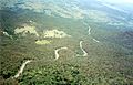
The Great Dividing Range, or the Eastern Highlands, is Australia's most substantial mountain range and the fifth longest land-based range in the world. It runs roughly parallel to the East Coast of Australia and stretches more than 3,500 kilometres (2,175 mi) from Dauan Island in the Torres Strait off the northern tip of Cape York Peninsula, Queensland, running the entire length of the eastern coastline through New South Wales, then into Victoria and turning west, before finally fading into the central plain at the Grampians in western Victoria.

Black Mountain (Kalkajaka) National Park is a 781-hectare (1,930-acre) protected area in Shire of Cook, Queensland, Australia.

The Main Range is a mountain range and national park in Queensland, Australia, located predominantly in Tregony, Southern Downs Region, 85 kilometres (53 mi) southwest of Brisbane. It is part of the World Heritage Site Gondwana Rainforests of Australia. It protects the western part of a semicircle of mountains in South East Queensland known as the Scenic Rim. This includes the largest area of rainforest in South East Queensland. The park is part of the Scenic Rim Important Bird Area, identified as such by BirdLife International because of its importance in the conservation of several species of threatened birds.

Mount Bartle Frere is the highest mountain in Queensland at an elevation of 1,611 metres (5,285 ft). The mountain was named after Sir Henry Bartle Frere, a British colonial administrator and then president of the Royal Geographical Society by George Elphinstone Dalrymple in 1873. Bartle Frere was British Governor of Cape Colony at the outset of the Zulu Wars.

The Mount Lindesay Highway is an Australian national highway located in Queensland, also known as National Route 13. The highway runs southwest from Brisbane, where it leaves Ipswich Road in the suburb of Moorooka, to the Queensland – New South Wales border and is approximately 116 kilometres (72 mi) in length. For most of its length it is roughly aligned with the Sydney–Brisbane rail corridor. At its southern end these transport routes take different passes over the Scenic Rim into the Northern Rivers region.

The Mitchell River is a river located in Far North Queensland, Australia. The river rises on the Atherton Tableland about 50 kilometres (31 mi) northwest of Cairns and flows about 750 kilometres (470 mi) northwest across Cape York Peninsula from Mareeba to the Gulf of Carpentaria.

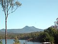
Spicers Peak is a mountain in Australia. It lies roughly 120 km west of Brisbane in the middle of the Main Range National Park. It is just south of Cunninghams Gap and Mount Mitchell. Its summit height is approximately 1,205 metres (3953 ft).
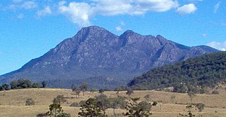
Mount Barney is a mountain within the Scenic Rim Region in south-east Queensland, Australia. It lies approximately 130 kilometres (81 mi) south-west of Brisbane, not far from the Queensland - New South Wales border, and forms part of the McPherson Range. It is a popular destination for bushwalkers and campers. Mount Barney is the sixth or seventh highest mountain in Queensland and is often regarded as one of the most impressive parts of the Scenic Rim. The mountain consists of two main peaks,, and smaller subsidiary peaks. East Peak is probably the most popular destination for bushwalkers.

Mount Cordeaux is a mountain near Brisbane, Australia and rises 1,135 m. It lies to the immediate north of Cunninghams Gap in the Main Range National Park. It is known to the Aboriginal People as Niamboyoo, however, the meaning is unknown. It appears that early usage on names for the mountain varied, as a 29 September 1897 report in the Warwick Examiner and Times, refers to "the well-known Cunningham's Gap, with its twin sentinel peaks, Coonyinirra and Niamboyoo".

Cunninghams Gap is a pass over the Great Dividing Range between the Darling Downs and the Fassifern Valley in Queensland, Australia. The Gap is the major route over the Main Range along the Great Dividing Range, between Warwick and Brisbane. The Cunningham Highway was built to provide road transport between the two regions.
Spicers Gap is a mountain pass that is located 100 kilometres (62 mi) west of Brisbane, Queensland, Australia, and was the original route over the Great Dividing Range in the area around Brisbane. Today it is included in Main Range National Park and is a popular destination for campers and bushwalkers. To the south of the gap is Spicers Peak. To the west of the mountain pass is Spicers Gap State Forest. Both the state forest and national park are part of the Gondwana Rainforests of Australia.
The Spicers Gap Road Conservation Park is a protected conservation park located within the Main Range National Park in south east Queensland, Australia. The park is part of the Main Range group World Heritage Site Gondwana Rainforests of Australia inscribed in 1986 and added to the Australian National Heritage List in 2007.
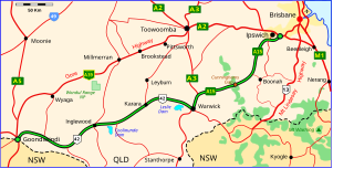
The Cunningham Highway is a 327-kilometre (203 mi) national highway located in south-eastern Queensland, Australia. The highway links the Darling Downs region with the urbanised outskirts of Ipswich via Cunninghams Gap.

South East Queensland (SEQ) is a bio-geographical, political, and administrative region of the state of Queensland in Australia, which contains more than 3.6 million people out of the state's population of 5.1 million. The area covered by South East Queensland varies, depending on the definition of the region, though it tends to include Queensland's three largest cities: the capital city Brisbane; the Gold Coast; and the Sunshine Coast. Its most common use is for political purposes, and covers 22,420 square kilometres (8,660 sq mi) and incorporates 11 local government areas, extending 240 kilometres (150 mi) from Noosa in the north to the Gold Coast and New South Wales border in the south, and 140 kilometres (87 mi) west to Toowoomba.

The Lockyer Creek is a creek located in South East Queensland, Australia. A tributary of the Brisbane River, the creek is a major drainage system in the Lockyer Valley. Rising on the eastern slopes of the Great Dividing Range, the creek flows generally north-easterly for more than 100 kilometres (62 mi) before it reaches its confluence with the Brisbane River north-northeast of Lowood, and downstream from the Wivenhoe Dam. The creek is named after Edmund Lockyer.
The Scenic Rim is a group of forested mountain ranges of the Great Dividing Range, located south of Brisbane agglomeration, straddling the border between south-eastern Queensland and north-eastern New South Wales, Australia.

The McIlwraith Range is a rugged, dissected granite plateau on the Cape York Peninsula of Far North Queensland, Australia. Part of the Great Dividing Range, the McIlwraith Range covers about 3,000 square kilometres (1,200 sq mi) and lies about 15 kilometres (9.3 mi) east of the town of Coen, and 550 kilometres (340 mi) north of Cairns. The Archer and Stewart Rivers rise in the range, with the Archer draining the range's western slopes into the Gulf of Carpentaria and the Stewart draining east into the Coral Sea. The range receives an annual rainfall of about 1,500 millimetres (59 in).

The Flinders Peak Group is an unnamed range of hills located on the northern edge of the Scenic Rim Region, south west of Logan City and south east of the City of Ipswich in South East Queensland, Australia. The summit in the Range is Flinders Peak reaching 680 metres (2,230 ft) above sea level.

Mount Edwards is a mountain in South East Queensland, Australia. The mountain rises 634 metres (2,080 ft) above sea level and is part of the Moogerah Peaks National Park. It lies approximately 100 km south west of Brisbane approximately 17 km(10.5 mi) from the town of Boonah. The mountain is the closest of the Moogerah Peaks to the Cunningham Highway and is 9 km south of Aratula. Other prominent peaks in this Scenic Rim group of mountains includes Mount French, Mount Moon and Mount Greville.

Spicers Gap Road is a heritage-listed road at Spicers Gap Road Conservation Park, Tregony, Southern Downs Region, Queensland, Australia. It was built from 1859 to 1865. It is also known as Spicers Gap Road Conservation Park and Spicers Peak Road. It was added to the Queensland Heritage Register on 23 July 1999.