
North Carolina is a state in the Southeastern region of the Southern United States. North Carolina is the 28th largest and 9th-most populous of the 50 United States. It is bordered by Virginia to the north, the Atlantic Ocean to the east, Georgia and South Carolina to the south, and Tennessee to the west. Raleigh is the state's capital and Charlotte is its largest city. The Charlotte metropolitan area, with an estimated population of 2,569,213 in 2018, is the most-populous metropolitan area in North Carolina, the 23rd-most populous in the United States, and the largest banking center in the nation after New York City. The Raleigh-Durham-Cary combined statistical area is the second-largest metropolitan area in the state, with an estimated population of 2,079,687 in 2019, and is home to the largest research park in the United States, Research Triangle Park.

Yancey County is a county located in the U.S. state of North Carolina. As of the 2010 census, the population was 17,818. Its county seat is Burnsville.

Mitchell County is a county located in the U.S. state of North Carolina. As of the 2010 census, the population was 15,579. Its county seat is Bakersville, population 454 (2010), elevation 2470 ft..

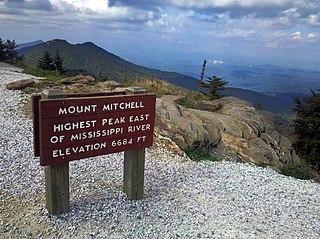
Mount Mitchell, known in Cherokee as Attakulla, is the highest peak of the Appalachian Mountains and the highest peak in mainland eastern North America. It is located near Burnsville in Yancey County, North Carolina; in the Black Mountain subrange of the Appalachians, about 19 miles (31 km) northeast of Asheville. It is protected by Mount Mitchell State Park and surrounded by the Pisgah National Forest. Mount Mitchell's elevation is 6,684 feet (2,037 m) above sea level.

The Blue Ridge Mountains are a physiographic province of the larger Appalachian Mountains range. The mountain range is located in the eastern United States, and extends 550 miles southwest from southern Pennsylvania through Maryland, West Virginia, Virginia, North Carolina, South Carolina, Tennessee, and Georgia. This province consists of northern and southern physiographic regions, which divide near the Roanoke River gap. To the west of the Blue Ridge, between it and the bulk of the Appalachians, lies the Great Appalachian Valley, bordered on the west by the Ridge and Valley province of the Appalachian range.
Mount Mitchell State Park is a 4,789-acre (19.38 km2) North Carolina state park in Yancey County, North Carolina in the United States. Established in 1915 by the state legislature, it became the first state park of North Carolina. By doing so, it also established the North Carolina State Parks System within the same bill.

Clingmans Dome is a mountain in the Great Smoky Mountains of Tennessee and North Carolina, in the southeastern United States. At an elevation of 6,643 feet (2,025 m), it is the highest mountain in the Great Smoky Mountains National Park, the highest point in the state of Tennessee, and the highest point along the 2,192-mile (3,528 km) Appalachian Trail. It is also the third highest point in mainland Eastern North America, after the nearby Mount Mitchell and Mount Craig.

Pisgah National Forest is a National Forest in the Appalachian Mountains of western North Carolina. It is administered by the United States Forest Service, part of the United States Department of Agriculture. The Pisgah National Forest is completely contained within the state of North Carolina. The forest is managed together with the other three North Carolina National Forests from common headquarters in Asheville, North Carolina. There are local ranger district offices located in Pisgah Forest, Mars Hill, and Nebo.

The Black Mountains are a mountain range in western North Carolina, in the southeastern United States. They are part of the Blue Ridge Province of the Southern Appalachian Mountains. The Blacks are the highest mountains in the Eastern United States. The range takes its name from the dark appearance of the red spruce and Fraser fir trees that form a spruce-fir forest on the upper slopes which contrasts with the brown or lighter green appearance of the deciduous trees at lower elevations. The Eastern Continental Divide, which runs along the eastern Blue Ridge crest, intersects the southern tip of the Black Mountain range.

Western North Carolina is the region of North Carolina which includes the Appalachian Mountains; it is often known geographically as the state's Mountain Region. It contains the highest mountains in the Eastern United States, with 125 peaks rising to over 5,000 feet elevation. Western North Carolina is sometimes included with upstate South Carolina as the "Western Carolinas", which is counted as a single media market. The region covers an area of about 11,000 square miles (28,000 km2), and is roughly the size of the state of Massachusetts. The population of the region, as measured by the 2010 U.S. Census, is 1,473,241, which is approximately 15% of North Carolina's total population.

Billy Mitchell Airport is a public use airport located four nautical miles east of the central business district of Hatteras, in Dare County, North Carolina, United States. The airport is located in the Cape Hatteras National Seashore and is owned by the National Park Service. It is named after United States Army Air Service General Billy Mitchell, and is included in the National Plan of Integrated Airport Systems for 2017–2021, which categorized it as a general aviation facility.

The April or Spring Nor'easter of 2007 was a nor'easter that affected mainly the eastern parts of North America during its four-day course, from April 14 to April 17, 2007. The combined effects of high winds, heavy rainfall, and high tides led to flooding, storm damages, power outages, and evacuations, and disrupted traffic and commerce. In the north, heavy wet snow caused the loss of power for several thousands of homes in Ontario and Quebec. The storm caused at least 18 fatalities.

NOAAS Mount Mitchell was an American survey vessel in commission in the National Oceanic and Atmospheric Administration from 1970 to 1995. Prior to her NOAA career, she was in commission in the United States Coast and Geodetic Survey as USC&GS Mount Mitchell from 1968 to 1970. In 2003, she returned to service as the private research ship R/V Mt. Mitchell.

Mount Craig, 6,647 feet (2,026 m), is the second highest peak of the Appalachian Mountains and second only to 6,684 feet (2,037 m) Mount Mitchell in eastern North America. It is located in the Black Mountains in Yancey County, North Carolina. The mountain lies about a mile (2 km) north of Mount Mitchell and is within Mount Mitchell State Park and the Pisgah National Forest.

In peak bagging terminology in the United States, the Southern Sixers refers to the group of mountains in the southern states of North Carolina and Tennessee with heights of at least six thousand feet. The southern sixers are the tallest group of mountains in the eastern United States and the only peaks in the Appalachian Mountains besides New Hampshire's Mount Washington to exceed 6,000 feet.

The southern Appalachian spruce–fir forest is an ecoregion of the temperate coniferous forests biome, a type of montane coniferous forest that grows in the highest elevations in the southern Appalachian Mountains of the eastern United States.

The March 2014 North American winter storm, also unofficially referred to as Winter Storm Titan, was an extremely powerful Winter storm that affected much of the United States and portions of Canada. It was one of the most severe winter storms of the 2013–14 North American winter storm season, storm affecting most of the Western Seaboard, and various parts of the Eastern United States, bringing damaging winds, flash floods, blizzard conditions, icy conditions.

Pisgah View State Park is a developing 205-acre (0.83 km2) North Carolina state park in Buncombe and Haywood Counties, North Carolina, in the United States. The center piece of the park is the approximately 1,600-acre (6.5 km2) Pisgah View Ranch, which has rental cabins, equestrian trails, a swimming pool, tennis courts and other amenities. The ranch has been privately owned by the Cogburn Family since the late 1700s, and the state acquired an option to purchase the property over a five year period. The Southern Appalachian Highlands Conservancy has raised $1 million to aid with the purchase. The Cogburns will donate a portion of the land's value to the state.