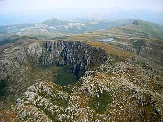
Cradle Mountain is a locality and mountain in the Central Highlands region of the Australian state of Tasmania. The mountain is situated in the Cradle Mountain-Lake St Clair National Park.

Lake St Clair or leeawulenna is a natural freshwater lake located in the Central Highlands area of Tasmania, Australia. The lake forms the southern end of the Cradle Mountain-Lake St Clair National Park. It has an area of approximately 45 square kilometres (17 sq mi), and a maximum depth of 215 metres (705 ft), making it Australia's deepest lake.
Trial Harbour is a rural locality in the local government area (LGA) of West Coast in the North-west and west LGA region of Tasmania. The locality is about 20 kilometres (12 mi) south-west of the town of Zeehan. The 2016 census has a population of 24 for the state suburb of Trial Harbour.

Central Plateau Conservation Area is an animal and plant conservation area in Tasmania, Australia. It is adjacent to the Walls of Jerusalem National Park.
Underwood is a rural locality and town in the local government area of Launceston, in the Northern region of Tasmania. It is located about 22 kilometres (14 mi) north-east of the city of Launceston. The 2016 census determined a population of 363 for the state suburb of Underwood.
Blackwall is a rural locality in the local government area (LGA) of West Tamar in the Launceston LGA region of Tasmania, Australia. The locality is about 21 kilometres (13 mi) south-east of the town of Beaconsfield. The 2016 census has a population of 270 for the state suburb of Blackwall. It is a small town located near Gravelly Beach on the western side of the Tamar River, north of Launceston.
Tarraleah is a rural locality in the local government area (LGA) of Central Highlands in the Central LGA region of Tasmania. In the 2016 census, a population of nil for the state suburb of Tarraleah was recorded.
Youngtown is a residential locality in the local government areas (LGA) of Launceston and Northern Midlands in the Launceston and Central LGA regions of Tasmania. The locality is about 6 kilometres (3.7 mi) south-east of the town of Launceston. The 2016 census has a population of 291 for the state suburb of Youngtown. It is a southern suburb of Launceston.

The Tyndall Range, commonly called The Tyndalls, is a mountain range that is part of the West Coast Range located in the Western region of Tasmania, Australia.

Glengarry is a rural locality in the local government area of West Tamar in the Launceston region of Tasmania. The locality is about 26 kilometres (16 mi) south-east of the town of Beaconsfield. The 2016 census has a population of 525 for the state suburb of Glengarry.
Kimberley is a rural locality and town in the local government areas of Meander Valley and Kentish in the Launceston and North-west and west regions of Tasmania. The locality is about 39 kilometres (24 mi) north-west of the town of Westbury. The 2016 census has a population of 149 for the state suburb of Kimberley. It is about midway between the towns of Sheffield and Deloraine. Once a thriving village with a school, railway station, shops and two churches, it is now a collection of houses with one church remaining.
Nunamara is a rural locality in the local government area (LGA) of Launceston in the Launceston LGA region of Tasmania. The locality is about 23 kilometres (14 mi) north-east of the town of Launceston. The 2016 census has a population of 291 for the state suburb of Nunamara.
Karoola is a rural locality and town in the local government area of Launceston, in the Northern region of Tasmania. It is located about 26 kilometres (16 mi) north of the city of Launceston. The 2016 census determined a population of 318 for the state suburb of Karoola.
Lebrina is a rural locality and town in the local government area of Launceston, in the Northern region of Tasmania. It is located about 38 kilometres (24 mi) north-east of the city of Launceston.
Targa is a rural locality in the local government area of Launceston, in the Northern region of Tasmania. It is located about 33 kilometres (21 mi) north-east of the city of Launceston. The 2016 census determined a population of 38 for the state suburb of Targa.
Golconda is a rural locality in the local government areas of Launceston and Dorset, in the Launceston and North-east regions of Tasmania. It is located about 31 kilometres (19 mi) south-west of the town of Scottsdale. The 2016 census determined a population of 26 for the state suburb of Golconda.
Lalla is a rural locality in the local government area (LGA) of Launceston in the Launceston LGA region of Tasmania. The locality is about 30 kilometres (19 mi) north of the town of Launceston. The 2016 census recorded a population of 87 for the state suburb of Lalla.
Middlesex is a rural locality in the local government areas (LGA) of Meander Valley, Central Coast and Kentish in the Launceston and North-west and west LGA regions of Tasmania. The locality is about 40 kilometres (25 mi) south-west of the town of Sheffield. The 2016 census recorded a population of 4 for the state suburb of Middlesex.
Erriba is a rural locality in the local government area (LGA) of Kentish in the North-west and west LGA region of Tasmania. The locality is about 37 kilometres (23 mi) south-west of the town of Sheffield. The 2016 census recorded a population of 47 for the state suburb of Erriba.


