Guildford is a rural locality in the local government area (LGA) of Waratah–Wynyard in the North-west and west LGA region of Tasmania. The locality is about 81 kilometres (50 mi) south of the town of Wynyard. The 2016 census has a population of nil for the state suburb of Guildford.
Boat Harbour is a rural locality in the local government area (LGA) of Waratah–Wynyard in the North-west and west LGA region of Tasmania. The locality is about 11 kilometres (6.8 mi) north-west of the town of Wynyard. The 2016 census has a population of 273 for the state suburb of Boat Harbour.
Heybridge is a semi-rural locality in the local government areas (LGA) of Central Coast and Burnie in the North-west and west LGA region of the Australian island state of Tasmania. The locality is about 9 kilometres (5.6 mi) south-east of the town of Burnie. The 2021 census recorded a population of 339 for the state suburb of Heybridge. It is a village located where the Bass Highway crosses the Blythe River, and is bounded by the Blythe River National Park to the south and Bass Strait to the north.
East Cam is a semi-rural locality in the local government area (LGA) of Burnie in the North-west and west LGA region of Tasmania. The locality is about 6 kilometres (3.7 mi) south-west of the town of Burnie. The 2016 census has a population of 170 for the state suburb of East Cam. The Burnie Golf Club is located within the suburb. The suburb is also the location for the Burnie Lawn Cemetery and as such there is a funeral home also located within the suburb. Forestry Tasmania have an office located in East Cam, there is a storage centre and there is also a vehicle repair centre.
Leith is a semi-rural locality in the local government areas (LGA) of Devonport and Central Coast in the North-west and west LGA region of Tasmania. The locality is about 10 kilometres (6.2 mi) east of the town of Ulverstone. The 2021 census recorded a population of 504 for the state suburb of Leith.
Stony Rise is a rural residential locality in the local government area (LGA) of Devonport in the North-west and west LGA region of Tasmania, Australia. The locality is about 4 kilometres (2.5 mi) south of the town of Devonport. The 2021 census recorded a population of 728 for the state suburb of Stony Rise. It is primarily a residential suburb of Devonport.
Nunamara is a rural locality in the local government area (LGA) of Launceston in the Launceston LGA region of Tasmania. The locality is about 23 kilometres (14 mi) north-east of the town of Launceston. The 2016 census has a population of 291 for the state suburb of Nunamara.
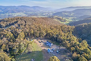
Lucaston is a rural locality in the local government area (LGA) of Huon Valley in the South-east LGA region of Tasmania. The locality is about 13 kilometres (8.1 mi) north-west of the town of Huonville. The 2016 census recorded a population of 354 for the state suburb of Lucaston.
Goulds Country is a rural locality in the local government area (LGA) of Break O'Day in the North-east LGA region of Tasmania. The locality is about 21 kilometres (13 mi) north-west of the town of St Helens and 147 kilometres east of the city of Launceston. The 2016 census recorded a population of 77 for the state suburb of Goulds Country.
Upper Esk is a rural locality in the local government areas (LGA) of Break O'Day and Dorset in the North-east LGA region of Tasmania. The locality is about 68 kilometres (42 mi) southeast of the town of Scottsdale. The 2016 census recorded a population of 26 for the state suburb of Upper Esk.
Forester is a rural locality in the local government area (LGA) of Dorset in the North-east LGA region of Tasmania. The locality is about 21 kilometres (13 mi) north-east of the town of Scottsdale. The 2016 census recorded a population of 8 for the state suburb of Forester.
Middlesex is a rural locality in the local government areas (LGA) of Meander Valley, Central Coast and Kentish in the Launceston and North-west and west LGA regions of Tasmania. The locality is about 40 kilometres (25 mi) south-west of the town of Sheffield. The 2016 census recorded a population of 4 for the state suburb of Middlesex.
Loyetea is a rural locality in the local government area (LGA) of Central Coast in the North-west and west LGA region of Tasmania. The locality is about 42 kilometres (26 mi) south-west of the town of Ulverstone. The 2021 census recorded a population of 20 for the state suburb of Loyetea.
South Preston is a rural locality in the local government area (LGA) of Central Coast in the North-west and west LGA region of Tasmania. The locality is about 28 kilometres (17 mi) south-west of the town of Ulverstone. The 2021 census recorded a population of 21 for the state suburb of South Preston.
Erriba is a rural locality in the local government area (LGA) of Kentish in the North-west and west LGA region of Tasmania. The locality is about 37 kilometres (23 mi) south-west of the town of Sheffield. The 2016 census recorded a population of 47 for the state suburb of Erriba.
Lower Beulah is a rural locality in the local government area (LGA) of Kentish in the North-west and west LGA region of Tasmania. The locality is about 17 kilometres (11 mi) south-east of the town of Sheffield. The 2016 census recorded a population of 55.
Lower Wilmot is a rural locality in the local government area (LGA) of Kentish in the North-west and west LGA region of Tasmania. The locality is about 29 kilometres (18 mi) north-west of the town of Sheffield. The 2016 census recorded a population of 115 for the state suburb of Lower Wilmot.
East Ridgley is a rural locality in the local government area (LGA) of Burnie in the North-west and west LGA region of Tasmania, Australia. The locality is about 18 kilometres (11 mi) south of the town of Burnie. The 2016 census recorded a population of 103 for the state suburb of East Ridgley.
Havenview is a rural residential locality in the local government area (LGA) of Burnie in the North-west and west LGA region of Tasmania. The locality is about 5 kilometres (3.1 mi) south of the town of Burnie. The 2016 census recorded a population of 715 for the state suburb of Havenview.
Parrawe is a rural locality in the local government areas (LGA) of Burnie and Waratah–Wynyard in the North-west and west LGA region of Tasmania. The locality is about 58 kilometres (36 mi) south-west of the town of Burnie. The 2016 census recorded a population of nil for the state suburb of Parrawe.
