The history of the Northern Territory began over 60,000 years ago when Indigenous Australians settled the region. Makassan traders began trading with the indigenous people of the Northern Territory for trepang from at least the 18th century onwards.
Europeans first sighted the coast of the future Territory in the 17th century. British groups made attempts to settle the coastal regions of the Territory from 1824 onwards, but no settlement proved successful until the establishment of Port Darwin in 1869.
Although sparse, the archaeological record of the Northern Territory provides evidence of settlement around 60,000 years ago at Malakunanja and Nauwalabila, although there is controversy surrounding the thermoluminescent dating of these sites.[1] During this period, sea levels were 100–150m (330–490ft) lower than at present, and Australia and New Guinea along with large tracts of what is now the Timor Sea formed one single landmass.
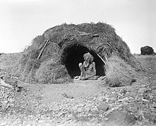
Abundant and complex rock art testifies to the rich cultural and spiritual lives of the original inhabitants of the Northern Territory, and in many areas of the Northern Territory there is a cultural continuum between the earliest inhabitants and the indigenous population today. Rock art is extremely difficult to date with any reliability, and it can also be difficult to identify a linear sequence of art due to the reworking and reinterpretation of older art by younger generations.
However archaeologists have been able to identify three distinct phases of art: pre-estuarine (dry climate and extinct animals), estuarine (rising sea levels and marine fauna), and freshwater (freshwater fauna, moving into 'historical' subjects such as Makassan traders, and European technology e.g. guns). Rock art also demonstrates cultural and technological changes. For instance, boomerangs give way to broad spearthrowers which give way to long spearthrowers, which give way to guns and boats.[2]
The dingo was introduced from Asia around 3,500 years ago and quickly became integrated into Aboriginal societies, where they played a role in hunting and provided warmth on cold nights.[3]
Sailors from the islands north of Australia were trading with northern coast of Australia before the Dutch arrived in the Indonesian Archipelago around 1600 AD. First the Baijini sea gypsy families came to trade for pearls and for oyster and turtle shell.[4] The Baijini brought their entire families and built houses of stone and ironbark. They planted rice in Warrimiri country and Gumatj country. Later the people who traded out of Makassar (now Ujung Pandang) came in search of trepang, which was prized for its culinary and medicinal values in Chinese markets. The Makassar came only to collect trepang, never setting up permanent camps with crops, apart from dropped tamarind seeds that sprouted. The annual Makassan voyages to the Kimberly and Arnhem Land dated from the 1700s, and ended in 1907 thanks to Australian regulations.[5] However, there are reports of visits perhaps 300 years prior to that, and extended from the Kimberleys in the west, to the east of Gulf of Carpentaria. The Makassans had extensive contact with the indigenous tribes of the Northern Territory, trading cloth, knives, alcohol, and tobacco for the right to fish in Territory waters and use Aboriginal labour.
The first recorded sighting of the Northern Territory coastline was by Dutch navigator Willem Janszoon aboard the ship Duyfken in 1606. Abel Tasman and numerous French navigators also charted the coast, naming many prominent features. Captain Phillip Parker King also made surveys of the coast.
Following British settlement in New South Wales in 1788, four unsuccessful attempts were made to settle coastal areas of the Northern Territory prior to the establishment of Darwin.
Letters Patent annexing the Northern Territory to South Australia, 1863Planting the first telegraph pole, near Palmerston (Darwin) in September 1870
1838–1861
The British made a third attempt in 1838, establishing Fort Victoria at Port Essington on 27 October 1838. Gordon Bremer was also in command of the new settlement, which was visited in July 1839 by HMSBeagle and her crew. Bremer left in 1839 and, following his departure, conditions in the settlement deteriorated. The Prussian naturalist and explorer Ludwig Leichhardt, travelled from Moreton Bay, overland to Port Essington. An unsuccessful migration scheme was tried, and the first Catholic priest, Father Angelo Confalonieri, arrived in the area in 1846. However, the settlement disbanded on 1 December 1849.
European explorers made their last great, often arduous, and sometimes tragic, expeditions into the interior of Australia during the second half of the 19th century – some with the official sponsorship of the colonial authorities and others commissioned by private investors. By 1850, large areas of the inland were still unknown to Europeans. Trailblazers like Edmund Kennedy, and Ludwig Leichhardt, had met tragic ends during the 1840s, attempting to fill in the gaps, but explorers remained ambitious to discover new lands for agriculture or answer scientific questions. Surveyors also acted as explorers and the colonies sent out expeditions to discover the best routes for lines of communication. The size of expeditions varied considerably, from small parties of just two or three, to large, well-equipped teams, led by gentlemen explorers assisted by smiths, carpenters, labourers and Aboriginal guides, and accompanied by horses, camels or bullocks.[6]
1862–1868
"Alexandra Land (Australia)" redirects here. Not to be confused with Alexandra, Victoria.
In 1862, John McDouall Stuart succeeded in traversing Central Australia from south to north. His expedition mapped out the route which was later followed by the Australian Overland Telegraph Line.[7][pageneeded] Stuart wanted the newly discovered region to be called "Alexandra Land", in honour of the Princess of Wales.[8] The name was gazetted in 1865 applying to the portion South of 16°S of what is now the Northern Territory.[9] For some time, Northern Territory including Arnhem Land referred only to the region north of that line.[10][11][12]
In 1863, the Northern Territory was annexed by South Australia by letters patent. Following the annexation, a fourth attempt at settlement occurred in 1864 at Escape Cliffs, about 75km (47mi) from present-day Darwin. Colonel Boyle Travers Finniss was responsible for the settlement. There were numerous confrontations with the local Marananggu people, and when he was recalled to Adelaide in 1867, the settlement disbanded. The South Australian government also tried to find sites for additional settlements, sending explorer John McKinlay to search in the region of the Adelaide River, but he had no success.
1869–1900
On 5 February 1869, George Goyder, the Surveyor-General of South Australia, established a small settlement of 135 men and women at Port Darwin. Goyder named the settlement Palmerston, after the British Prime Minister Lord Palmerston. In 1870, the first poles for the Overland Telegraph were erected in Darwin.
Uluru and Kata Tjuta were first mapped by Europeans in 1872, during the expeditionary period made possible by the construction of the Australian Overland Telegraph Line. In separate expeditions, Ernest Giles and William Gosse were the first European explorers to the area. While exploring the area in 1872, Giles sighted Kata Tjuta from a location near Kings Canyon, naming it Mount Olga for Queen Olga of Württemberg, and in the following year, Gosse observed Uluru and named it Ayers Rock, in honour of the Premier of South AustraliaSir Henry Ayers. The barren desert lands of Central Australia disappointed the Europeans as unpromising for pastoral expansion, but would later come to be appreciated as emblematic of Australia.
The construction of the Overland Telegraph, connecting Australia to the rest of the world, led to more exploration of the interior of the Territory, and the discovery of gold at Pine Creek in the 1880s drove further economic development
20th century
Map of the Northern Territory in 1916
On 1 January 1911, a decade after federation, the Northern Territory was separated from South Australia and transferred to Australian government control, under the South Australian Northern Territory Surrender Act 1907, and the federal Northern Territory Acceptance Act 1910.[13][14] The Northern Territory (Administration) Act provided that there would be an Administrator appointed by the Governor-General to administer the Territory on behalf of the Australian Government, subject to any instructions given to him by the appropriate Minister from time to time.
In late 1912, there was growing sentiment that the name "Northern Territory" was unsatisfactory.[15][16] The names "Kingsland" (after King George V and to correspond with Queensland), "Centralia" and "Territoria" were proposed, with Kingsland becoming the preferred choice in 1913. However, the name change never went ahead.[17][18]
For a brief time between 1926 and 1931, the Northern Territory was divided into North Australia and Central Australia at the 20th parallel south of latitude.[19] Soon after that, under the Kimberley Scheme, parts of the Northern Territory were considered as a possible site for the establishment of a Jewish Homeland, but it was understandably considered to be the "Unpromised Land".[20]
Central Australia
Between 1918 and 1921, large areas of the Territory and adjacent states were classified as Aboriginal reserves and sanctuaries for remaining nomadic populations who had hitherto had little contact with Europeans. In 1920, the area including Uluru, in Anangu territory, was declared an Aboriginal Reserve under the Aboriginals Ordinance (Northern Territory). Nevertheless, small numbers of non-Aboriginal people continued to visit the area, including missionaries, adventurers, native welfare patrol officers and dingo scalpers. In 1931, the gold prospector Harold Lasseter died in the area, while searching for his famous reef of gold. The return of pastoralists to the region created conflict with the Aboriginal people, amid competition for scarce resources. In 1940, the reserve was reduced in size to facilitate access for gold prospecting.[21]
Tourists had begun arriving at Uluru in 1936. A vehicular track was made in 1948. Post-war assimilation policies anticipated that the Pitjantjatjara and Yankunytjatjara people would assimilate into Australian society and welfare authorities moved them to Aboriginal settlements to facilitate this process.[22]
Caledon Bay crisis
The Caledon Bay crisis of 1932–34 saw one of the last incidents of violent interaction on the 'frontier' between indigenous and non-indigenous Australians. It began with the spearing of Japanese poachers who had been molesting Yolngu women, and was followed by the killing of a policeman. As the crisis unfolded, national opinion swung behind the Aboriginal people involved, and the first appeal on behalf of an Indigenous Australian to the High Court of Australia was launched. Following the crisis, the anthropologist Donald Thomson was dispatched by the government to live among the Yolngu.[23]
World War Two
The Bombing of Darwin, 19 February 1942. During World War II the Territory suffered attacks from Imperial Japan.
Indigenous Australians had struggled for rights to fair wages and land. An important event in this struggle was the strike and walk off by the Gurindji people at Wave Hill, cattle station in 1966. The Commonwealth Government of Gough Whitlam set up the Woodward Royal Commission in February 1973 set to inquire into how land rights might be achieved in the Northern Territory. Justice Woodward's first report in July 1973 recommended that a Central Land Council and a Northern Land Council be established in order to present to him the views of Aboriginal people. In response to the report of the Royal Commission a Land Rights Bill was drafted, but the Whitlam government was dismissed before it was passed.
From 1863 to 1911, the Northern Territory was a part of South Australia. In 1890, South Australia made the Northern Territory a separate electoral district with two parliamentary representatives and granted the vote to its adult males (and adult females from 1895). Indigenous Australians also had the right to vote. Their status as South Australian voters also qualified them to vote in elections for both Houses of the Commonwealth Parliament at the first federal elections in 1901. In 1911, however, the Northern Territory was transferred to the Commonwealth government. The territory was placed under the direct control of the federal Minister for External Affairs and the population had no parliamentary representation or voting rights. At the time of the Commonwealth takeover, the Territory's population was 3,031.[24][25]
In 1922 the territory was granted one representative in the Australian House of Representatives. The member could speak in the House and take part in committee work, but could not vote, and did not count for the purpose of forming government.[25] Indigenous people were excluded from voting for the representative.[26] Between 1936 and 1959 the Member was only able to vote in motions to disallow laws made for the Territory, and between 1959 and 1968, the Member could only vote on matters relating to the Territory alone. In 1968, the Member for Northern Territory acquired full voting rights.
In 1947, the territory was granted a Legislative Council with six elected members and seven members appointed by the Administrator for the Northern Territory. Adult European residents of the territory were entitled to vote.[27] In 1962, Aboriginal Territorians were granted the right to vote in territorial and federal elections.[26]
In 1974, a fully elected Legislative Assembly was established and the Northern Territory had its first representative parliament. In 1977 the Commonwealth Parliament passed the Northern Territory (Self-Government) Act and the territory achieved responsible government. In 1978, the first ministry was established and the assembly was given responsibility for the finances of the territory.[28]
In 1978 the Territory was granted responsible government, with a Legislative Assembly headed by a Chief Minister, publishing official notices in its own Government Gazette.
The Country Liberal Party (CLP) was established in the Northern Territory in 1974 by supporters of the Liberal and Country Parties of Australia living in the Territory; thereafter it enjoyed considerable electoral success.[30] The Party has contested general elections in the Territory since 1974 and saw unbroken electoral success from 1974 until 2001 when it lost office to the Australian Labor Party.[30]Clare Martin won a surprise victory at the 2001 territory election, becoming the first Labor Party, and first female Chief Minister. The ALP member for Arafura Marion Scrymgour, became the Labor Party Deputy Chief Minister of the Northern Territory from November 2007 until February 2009. She was the highest-ranked indigenous person in government in Australia's history. She was also the first indigenous woman to be elected to the Northern Territory Parliament.[31]
The 2012 Northern Territory general election ended 11 years of Labor rule and saw Terry Mills defeat the Incumbent Labor government led by Paul Henderson. The victory was also notable for the support it achieved from indigenous people in pastoral and remote electorates. Large swings were achieved in remote Territory electorates (where the indigenous population comprised around two thirds of voters) and a total of five Aboriginal CLP candidates won election to the Assembly.[32] Among the Aboriginal candidates elected was high-profile Aboriginal activist Bess Price and former Labor member Alison Anderson. Anderson was appointed Minister for Indigenous Advancement. In her first ministerial statement on the status of Aboriginal communities in the Territory she said the CLP would focus on improving education and on helping create real jobs for indigenous people.[33] However, Alison Anderson resigned from the CLP in 2014, along with two other indigenous MPs, briefly becoming an independent once again. On 27 April 2014 the three MLAs had joined the Palmer United Party, with Anderson serving as parliamentary leader[34]
Recent history
The Northern Territory was briefly in 1995-6 one of the few places in the world with legal voluntary euthanasia, until the Federal Parliament overturned the legislation. Before the overriding legislation was enacted, three people had been voluntarily euthanized by Dr Philip Nitschke.[citation needed]
In 2007, the Australian Federal Government implemented the Northern Territory National Emergency Response (also referred to as "the intervention") a controversial policy package that enforced welfare, law enforcement and land provision measures to address allegations of child sexual abuse and neglect in Northern Territory Aboriginal Communities. The initiative attracted controversy for its implementation – including the overturning of the Racial Discrimination Act 1975, the deployment of over 600 Australian Defence Force personnel into Aboriginal communities, lack of community consultation and compulsory acquisition of townships.[35] It has been condemned as nothing more than a hasty reaction to allegations made in 2006 regarding child sexual assault in Aboriginal communities. As well as this, some view it as another attempt by the government to control these communities.[36]
The Country Liberal Party of the Northern Territory (CLP), commonly known as the Country Liberals, is a centre-right and conservative political party in Australia's Northern Territory. In territory politics, it operates in a two-party system with the Australian Labor Party (ALP). It also contests federal elections as an affiliate of the Liberal Party of Australia and National Party of Australia, the two partners in the federal coalition.
The Northern Territory is an Australian internal territory in the central and central-northern regions of Australia. The Northern Territory shares its borders with Western Australia to the west, South Australia to the south, and Queensland to the east. To the north, the Northern Territory looks out to the Timor Sea, the Arafura Sea and the Gulf of Carpentaria, including Western New Guinea and various other islands of the Indonesian archipelago.
Clare Majella Martin is a former Australian journalist and politician. She was elected to the Northern Territory Legislative Assembly in a shock by-election win in 1995. She was appointed Opposition Leader in 1999, and won a surprise victory at the 2001 territory election, becoming the first Labor Party (ALP) and first female Chief Minister of the Northern Territory. At the 2005 election, she led Territory Labor to the second-largest majority government in the history of the Territory, before resigning as Chief Minister on 26 November 2007.
Uluṟu-Kata Tjuṯa National Park is a protected area in the Northern Territory of Australia. The park is home to both Uluru and Kata Tjuta. It is located 1,943 kilometres (1,207 mi) south of Darwin by road and 440 kilometres (270 mi) south-west of Alice Springs along the Stuart and Lasseter Highways. The park covers 1,326 square kilometres (512 sq mi) and includes the features it is named after: Uluru and, 40 kilometres (25 mi) to its west, Kata Tjuta. The location is listed as a UNESCO World Heritage Site for natural and cultural landscape.
Uluru, also known as Ayers Rock and officially gazetted as Uluru / Ayers Rock, is a large sandstone monolith. It crops out near the centre of Australia in the southern part of the Northern Territory, 335 km (208 mi) south-west of Alice Springs.
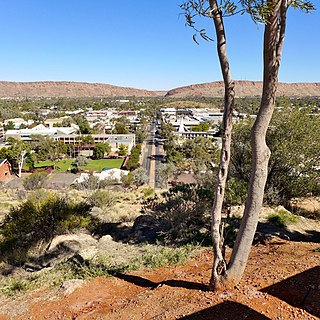
Alice Springs is a town in the Northern Territory, Australia; it is the third-largest settlement after Darwin and Palmerston. The name Alice Springs was given by surveyor William Whitfield Mills after Alice, Lady Todd, wife of the telegraph pioneer Sir Charles Todd. Known colloquially as The Alice or simply Alice, the town is situated roughly in Australia's geographic centre. It is nearly equidistant from Adelaide and Darwin.
Marshall Bruce Perron is a former Australian politician, who was a Country Liberal Party member of the Legislative Assembly in the Northern Territory from the formation of the Assembly in 1974 until his resignation in 1995. For the last 20 years, save for an 11-month break in 1986 and 1987, he served as a cabinet minister or its equivalent. From 1988 to 1995, Perron was the Chief Minister of the Northern Territory.
The following is an alphabetical list of articles related to Australia.
The Legislative Assembly of the Northern Territory is the unicameral legislature of Australia’s Northern Territory. The Legislative Assembly has 25 members, each elected in single-member electorates for four-year terms. The voting method for the Assembly is the full-preferential voting system, having previously been optional preferential voting. Elections are on the fourth Saturday in August of the fourth year after the previous election, but can be earlier in the event of a no-confidence vote in the government. The most recent election for the Legislative Assembly was the 2024 election held on 24 August. The next election is scheduled for 26 August 2028.
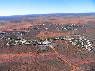
Yulara is a town in the southern region of the Northern Territory, Australia. It is an unincorporated enclave within the MacDonnell Region. At the 2016 census, Yulara had a permanent population of 1,099, in an area of 103.33 square kilometres (39.90 sq mi). It is 18 kilometres (11 mi) by road from the World Heritage Site of Uluru, and 55 kilometres (34 mi) from Kata Tjuta. It is in the Northern Territory electorate of Gwoja and the federal electorate of Lingiari.
The Pitjantjatjara are an Aboriginal people of the Central Australian desert near Uluru. They are closely related to the Yankunytjatjara and Ngaanyatjarra and their languages are, to a large extent, mutually intelligible.
Mutitjulu is an Aboriginal Australian community in the Northern Territory of Australia located at the eastern end of Uluṟu. It is named after a knee-shaped water-filled rock hole at the base of Uluṟu, and is located in the Uluṟu-Kata Tjuṯa National Park. Its people are traditional owners and joint managers of the park with Parks Australia. At the 2011 census, Mutitjulu had a population of 296, of which 218 (71.2%) were Aboriginal.
Arnhem is an electoral division of the Legislative Assembly in Australia's Northern Territory. It was first created in 1974, and takes its name from Arnhem Land, the region encompassing much of the northern part of the Territory.
Adam Graham Giles is an Australian former politician and former Chief Minister of the Northern Territory (2013–2016) as well as the former leader of the Country Liberal Party (CLP) in the unicameral Northern Territory Parliament. Giles is the first Indigenous Australian to serve as a head of government in Australia.
The 2016 Northern Territory general election was held on Saturday 27 August 2016 to elect all 25 members of the Legislative Assembly in the unicameral Northern Territory Parliament.
The Katiti Aboriginal Land Trust is a land trust for a block of land in the southwest of the Northern Territory of Australia located in the locality of Petermann. It was created through the Katiti Land Claim in 1980. The trust's owners include Pitjantjatjara, Yankunytjatjara and Luritja people. The block of land is officially referred to as Northern Territory Portion 1818. It borders the larger Petermann Land Trust area and Uluṟu–Kata Tjuṯa National Park to the north and west, and two pastoral stations to the east and south: Curtin Springs and Mulga Park. The town of Yulara is excluded from the Land Trusts, and sits between the Katiti block and Uluṟu–Kata Tjuṯa National Park.
Indigenous treaties in Australia are proposed binding legal agreements between Australian governments and Australian First Nations. A treaty could recognise First Nations as distinct political communities, acknowledge Indigenous Sovereignty, set out mutually recognised rights and responsibilities or provide for some degree of self-government. As of 2024, no such treaties are in force, however the Commonwealth and all states except Western Australia have expressed support previously for a treaty process. However, the defeat of the Voice referendum in 2023 has led to a reversal by several state branches of the Liberal and National parties in their support for treaty and a much more ambiguous expressed position by state branches of the Labor Party as well as Labor governments.
Petermann is a locality in the Northern Territory of Australia located about 1,427 kilometres (887 mi) south of the territory capital of Darwin in the territory’s south-western corner adjoining the states of South Australia and Western Australia.
Nipper Winmarti also recorded as Nipper Winmati was a Pitjantjatjara man who worked as an Aboriginal tracker at the Uluṟu-Kata Tjuṯa National Park where he was also recognised as a traditional owner. Winmarti worked as a tracker following the death of Azaria Chamberlain in 1980 and believed that baby Azaria had been taken by a dingo; he was the only Aboriginal tracker to give evidence at the first inquest.
↑ "Explorers". Culture and Recreation, Australia. Archived from the original on 8 April 2011. Retrieved 6 November 2013.
↑ Flannery, Tim (1998). The Explorers. Text Publishing.
↑ Manning, Geoffrey. "The Manning Index – Place Names of South Australia – S". Retrieved 18 September 2020– via State Library South Australia. in exercise of the usual right of explorers [I] have named the portion of the continent of Australia recently discovered... Alexandra Land, in honour of the Princess of Wales
↑ Strangways, H.B.T. (25 April 1856). "South Australian Government Gazette, No 18"(PDF). Adelaide: Crown Lands Office. p.372. Retrieved 18 September 2020– via Australasian Legal Information Institute. It is hereby notified, for general information, that His Excellency the Governor-in-Chief has been pleased to direct that all that portion of the South Australian Territory, forming the central portion of the Continent, and lying to the south of the 16th and north of the 26th degrees of south latitude, shall henceforth bear the name of 'Alexandra Land.'
↑ "1 map: col.; 18.8 x 25.7cm.", Australia, 1879, nla.obj-232364593, retrieved 18 September 2020– via Trove
↑ John Sands (Firm). (1886), "1 map: col.; 28.0 x 39.8cm.", Australia, Sydney: J. Sands, nla.obj-231051974, retrieved 18 September 2020– via Trove
↑ Cram, George Franklin (1901). Australia (Map). 1: 12 517 000. Chicago. Tasmania inset. Retrieved 18 September 2020.
This page is based on this Wikipedia article Text is available under the CC BY-SA 4.0 license; additional terms may apply. Images, videos and audio are available under their respective licenses.