Coolgardie woodlands

Last updated
Coolgardie woodlands
Great Western Woodlands.jpg
Eucalyptus woodlands near Norseman, Western Australia
IBRA 6.1 Coolgardie.png
Ecoregion territory (in red)
Ecology
Realm Australasian
Biome Mediterranean forests, woodlands, and scrub
Borders
Geography
Area140,001 km2 (54,055 sq mi)
Country Australia
States Western Australia
Coordinates 31°46′S121°44′E / 31.77°S 121.74°E / -31.77; 121.74 Coordinates: 31°46′S121°44′E / 31.77°S 121.74°E / -31.77; 121.74
Conservation
Conservation status Critical/endangered
Protected16,323 km² (12%) [1]

The Coolgardie woodlands is an ecoregion in southern Western Australia. The predominant vegetation is woodlands and mallee scrub. The ecoregion is a transitional zone between the Mediterranean-climate forests, woodlands, and shrublands of Southwest Australia and the deserts and dry scrublands of the Australian interior. [2] [3] [4] [5]

Contents

Location and description

The Coolgardie woodlands is part of the Mediterranean-climate Southwest Australia biogeographic region, whose forests, woodlands, and shrublands are globally noteworthy for their diversity of plant species.

The Coolgardie woodlands ecoregion consists of two IBRA regionsCoolgardie and the smaller Hampton bioregion. Coolgardie bioregion is bounded on the south and west by Mediterranean-climate ecoregions, the coastal Esperance mallee ecoregion to the south, and the Southwest Australia savanna ecoregion to the west. The Coolgardie woodlands' northern boundary is the Mulga-eucalypt line, which marks the boundary between eucalypt-dominated woodlands of Southwest Australia and the drier Mulga (Acacia-dominated) woodlands of Australia's interior. The Western Australian mulga shrublands, Great Victoria Desert, and Nullarbor Plains xeric shrublands ecoregions lie to the north.

The Hampton region is coastal, lying southeast of the Coolgardie region on the shore of the Great Australian Bight. It is bounded on the north and east by the Nullarbor Plains xeric shrublands. [2]

Flora

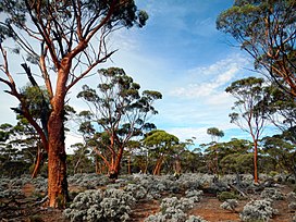
The ecoregion is home to several plant communities, including eucalyptus woodlands and shrublands of mallee and acacia. Woodlands of Salmon gum (Eucalyptus salmonophloia) and gimlet (Eucalyptus salubris) are common in central Coolgardie, generally on rolling plains and river valleys on red loam soils over red clay. Salmon gums reach 15-20 meters in height, and gimlet a height of 8 to 12 meters. The woodlands are open and irregular, and with an understory of low shrubs (including Maireana sedifolia and Atriplex spp.), herbs, and grasses. [6]

Protected areas

A 2017 assessment found that 16,323 km², or 12%, of the ecoregion is in protected areas – 14,731 km² (11%) of the Coolgardie region and 1,592 km² (15%) of the Hampton region. [1] Protected areas in the Coolgardie region include Karroun Hill Nature Reserve in the northwestern corner, Mount Manning Nature Reserve, Jilbadji Nature Reserve, and Goldfields Woodlands National Park in western Coolgardie, and Dundas Nature Reserve which extends south into the Esperance mallee. Ngadju Indigenous Protected Area was established in 2020, and protects extensive areas of woodland. [7]

The coastal Nuytsland Nature Reserve covers the western portion of the Hampton region, and Nullarbor National Park covers its easternmost portion.

See also

Related Research Articles

Great Victoria Desert Desert in Western Australia and South Australia

The Great Victoria Desert is a sparsely populated desert ecoregion and interim Australian bioregion in Western Australia and South Australia.

Carnarvon xeric shrublands Terrestrial ecoregion in Western Australia

The Carnarvon xeric shrublands is a deserts and xeric shrublands ecoregion of Western Australia. The ecoregion is coterminous with the Carnarvon Interim Biogeographic Regionalisation for Australia (IBRA) bioregion.

Southwest Australia Biogeographic region of Western Australia

Southwest Australia is a biogeographic region in Western Australia. It includes the Mediterranean-climate area of southwestern Australia, which is home to a diverse and distinctive flora and fauna.

Esperance Plains Biogeographic region in Western Australia

Esperance Plains, also known as Eyre Botanical District, is a biogeographic region in southern Western Australia on the south coast between the Avon Wheatbelt and Hampton bioregions, and bordered to the north by the Mallee region. It is a plain punctuated by granite and quartz outcrops and ranges, with a semi-arid Mediterranean climate and vegetation consisting mostly of mallee-heath and proteaceous scrub. About half of the region has been cleared for intensive agriculture. Recognised as a bioregion under the Interim Biogeographic Regionalisation for Australia (IBRA), it was first defined by John Stanley Beard in 1980.

Mallee bioregion Biogeographic region in southern Western Australia

Mallee, also known as Roe Botanical District, is a biogeographic region in southern Western Australia. Located between the Esperance Plains, Avon Wheatbelt and Coolgardie bioregions, it has a low, gently undulating topography, a semi-arid mediterranean climate, and extensive Eucalyptus mallee vegetation. It has an area of 73,975.59 square kilometres (28,562.13 sq mi). About half of the region has been cleared for intensive agriculture. Recognised as a region under the Interim Biogeographic Regionalisation for Australia (IBRA), it was first defined by John Stanley Beard in 1980.

Esperance mallee

Esperance mallee is an ecoregion on the south coast of Western Australia, a coastal strip where the predominant vegetation consists of short eucalyptus trees and shrubs.

Avon Wheatbelt Bioregion in Western Australia

The Avon Wheatbelt is an Australian bioregion in Western Australia. It has an area of 9,517,104 hectares. It is considered part of the larger Southwest Australia savanna ecoregion.

Coolgardie bioregion Australian bioregion

Coolgardie is an Australian bioregion consisting of an area of low hills and plains of infertile sandy soil in Western Australia. It has an area of 129,122.09 square kilometres (49,854.32 sq mi). It includes much of the Great Western Woodlands.

Hampton bioregion Bioregion in Western Australia

Hampton is an interim Australian bioregion located in southeastern coastal Western Australia, with a small portion (4%) extending into adjacent South Australia. It has an area of 1,088,198 hectares. The Hampton bioregion is part of the Coolgardie woodlands ecoregion.

Yalgoo bioregion Biogeographic region in Western Australia

Yalgoo is an interim Australia bioregion located in Western Australia. It has an area of 5,087,577 hectares. The bioregion, together with the Avon Wheatbelt and Geraldton Sandplains bioregions, is part of the larger Southwest Australia savanna ecoregion as classified by the World Wildlife Fund.

Geography of Western Australia

Western Australia occupies nearly one third of the Australian continent. Due to the size and the isolation of the state, considerable emphasis has been made of these features; it is the second largest administrative territory in the world, after Yakutia in Russia, despite the fact that Australia is only the sixth largest country in the world by area, and no other regional administrative jurisdiction in the world occupies such a high percentage of a continental land mass. It is also the only first level administrative subdivision to occupy the entire continental coastline in one cardinal direction.

Mulga Lands

The Mulga Lands are an interim Australian bioregion of eastern Australia consisting of dry sandy plains with low mulga woodlands and shrublands that are dominated by Acacia aneura (mulga). The Eastern Australia mulga shrublands ecoregion is coterminous with the Mulga Lands bioregion.

Eyre Yorke Block

The Eyre Yorke Block, also known as the Eyre and Yorke mallee, is an interim Australian (IBRA) bioregion and a World Wildlife Fund ecoregion covering part of the Eyre Peninsula and all of Yorke Peninsula as well as land to its immediate east in South Australia.

Mount Lofty woodlands Ecoregion in South Australia

The Mount Lofty woodlands is an ecoregion in South Australia. It includes woodlands, shrublands, and grasslands in the Mount Lofty Ranges, Fleurieu Peninsula, and Kangaroo Island.

Southwest Australia savanna Terrestrial ecoregion in Western Australia

The Southwest Australia savanna is an ecoregion in Western Australia.

Tirari–Sturt stony desert

The Tirari–Sturt stony desert is a deserts and xeric shrublands ecoregion in central Australia.

Western Australian mulga shrublands Terrestrial ecoregion in Western Australia

The Western Australian Mulga shrublands is a deserts and xeric shrublands ecoregion of inland Western Australia. It is one of Australia's two mulga ecoregions, characterized by dry woodlands of mulga trees interspersed with areas of grassland and scrub.

Pilbara shrublands Terrestrial ecoregion in Western Australia

The Pilbara shrublands is a deserts and xeric shrublands ecoregion in Western Australia. It is coterminous with the Pilbara IBRA region. For other definitions and uses of "Pilbara region" see Pilbara.

Southeast Australia temperate forests Terrestrial ecoregion in Australia

The Southeast Australia temperate forests is a temperate broadleaf and mixed forests ecoregion of south-eastern Australia. It includes the temperate lowland forests of southeastern Australia, at the southern end of the Great Dividing Range. Vegetation ranges from wet forests along the coast to dry forests and woodlands inland.

References

  1. 1 2 Dinerstein, Eric; Olson, David; et al. (June 2017). "An Ecoregion-Based Approach to Protecting Half the Terrestrial Realm". BioScience. 67 (6): 534–545. doi: 10.1093/biosci/bix014 . PMC   5451287 . PMID   28608869.{{cite journal}}: CS1 maint: date and year (link) Supplemental material 2 table S1b.
  2. 1 2 "Coolgardie woodlands". Terrestrial Ecoregions. World Wildlife Fund.
  3. "Map of Ecoregions 2017". Resolve. Retrieved August 20, 2021.
  4. "Coolgardie woodlands". Digital Observatory for Protected Areas. Retrieved August 20, 2021.
  5. "Coolgardie woodlands". The Encyclopedia of Earth. Retrieved August 20, 2021.
  6. Elith, Jane and Sjaan Bidwell (2004). Identification and Assessment of Nationally Threatened Woodlands. Description of Ecological Communities: Arid Eucalypt Woodlands. Report to the Commonwealth Department of the Environment and Heritage, 2004.
  7. Ley, Sussan (October 4, 2020). "Indigenous Protected Areas expanded by 7 million hectares". Australian Government. Government of Australia. Retrieved 2022-05-12.