Names such as the South West or South West corner, when used to refer to a specific area of Western Australia, denote a region that has been defined in several different ways.
While styles like South-West and Southwest have sometimes been used, most media outlets and official sources in Western Australia now use Australian English spelling conventions, under which the names of intercardinal points are two separate and unhyphenated words, i.e. "SouthWest".
Such names now usually refer to areas immediately south of the Perth metropolitan area and west of the Wheatbelt. Its narrowest and most specific usage is in reference to the official, government-designated South West region. However, broader usages may include the entire south-western quarter of Australia.
In regard to Western Australia, "South West" may refer to:
This article includes a list of related items that share the same name (or similar names). If an internal link incorrectly led you here, you may wish to change the link to point directly to the intended article.
Related Research Articles
Holland is a region and former province on the western coast of the Netherlands. The name Holland is also frequently used informally to refer to the entirety of the country Netherlands. This usage is commonly accepted in other countries, and sometimes employed by the Dutch themselves. However, some in the Netherlands, particularly those from regions outside Holland, may find it undesirable or misrepresentative to use the term for the whole country.
The Great Dividing Range, or the Eastern Highlands, is Australia's most substantial mountain range and the fifth longest land-based range in the world. It stretches more than 3,500 kilometres (2,175 mi) from Dauan Island in the Torres Strait off the northern tip of Cape York Peninsula, Queensland, running the entire length of the eastern coastline through New South Wales, then into Victoria and turning west, before finally fading into the central plain at the Grampians in western Victoria.
Township refers to various kinds of settlements or administrative subdivisions in different countries.
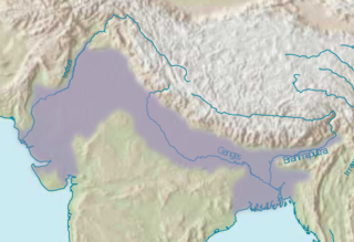
The Indo-Gangetic Plain, also known as the Indus-Ganga Plain and the North Indian River Plain, is a 630-million-acre (2.5-million km2) fertile plain encompassing northern regions of the Indian subcontinent, including most of northern and eastern India, the eastern parts of Pakistan, virtually all of Bangladesh and southern plains of Nepal. The region is named after the Indus and the Ganges rivers and encompasses a number of large urban areas. The plain is bound on the north by the Himalayas, which feed its numerous rivers and are the source of the fertile alluvium deposited across the region by the two river systems. The southern edge of the plain is marked by the Chota Nagpur Plateau. On the west rises the Iranian Plateau.
The south-west corner drainage region of Western Australia is one of only two temperate and relatively fertile parts of mainland Australia. It covers about 140,000 square kilometres (54,000 sq mi), or a little less than 2% of the continent. For comparison, this is about the same size as North Carolina or a little larger than England.
The Kootenays or Kootenay is a region of southeastern British Columbia. It takes its name from the Kootenay River, which in turn was named for the Kutenai First Nations people.
Western Australia (WA) is divided into regions according to a number of systems.
Southwest Australia is a biogeographic region in Western Australia. It includes the Mediterranean-climate area of southwestern Australia, which is home to a diverse and distinctive flora and fauna.
New Holland is a historical European name for mainland Australia.
Chennai district, formerly known as Madras district, is one of the 38 districts in the state of Tamil Nadu in India. It is the smallest and densest of all the districts in the state. Most of the Greater Chennai City comes under this district, erstwhile under Tiruvallur, Kanchipuram and Chengalpattu districts. As of 2011, the district had a population of 7,100,000 with a sex-ratio of 989 females for every 1,000 males.
Water Corporation is the principal supplier of water, wastewater and drainage services throughout the state of Western Australia. It is the seventh successive agency to deal with the services in Perth, Western Australia.
The British Columbia Interior, BC Interior or Interior of British Columbia, usually referred to only as the Interior, is one of the three main regions of the Canadian province of British Columbia, the other two being the Lower Mainland, which comprises the overlapping areas of Greater Vancouver and the Fraser Valley, and the Coast, which includes Vancouver Island and also including the Lower Mainland.
Mallee, also known as Roe Botanical District, is a biogeographic region in southern Western Australia. Located between the Esperance Plains, Avon Wheatbelt and Coolgardie regions, it has a low, gently undulating topography, a semi-arid mediterranean climate, and extensive Eucalyptus mallee vegetation. About half of the region has been cleared for intensive agriculture. Recognised as a region under the Interim Biogeographic Regionalisation for Australia (IBRA), it was first defined by John Stanley Beard in 1980.
Warren, also known as Karri Forest Region and the Jarrah-Karri forest and shrublands ecoregion, is a biogeographic region in southern Western Australia. Located in the southwest corner of Western Australia between Cape Naturaliste and Albany, it is bordered to the north and east by the Jarrah Forest region. Its defining characteristic is an extensive tall forest of Eucalyptus diversicolor (karri). This occurs on dissected, hilly ground, with a moderately wet climate. Karri is a valuable timber and much of the karri forest has been logged over, but less than a third has been cleared for agriculture. Recognised as a region under the Interim Biogeographic Regionalisation for Australia (IBRA), and as a terrestrial ecoregion by the World Wide Fund for Nature, it was first defined by Ludwig Diels in 1906.
The lands administrative divisions of Western Australia refer to subdivisions of the state of Western Australia for cadastral purposes, most of which have been in place since the 19th century. The state is divided up for this purpose into five land divisions, which in turn are subdivided into land districts, which correspond to counties in other Australian states. These districts are then subdivided further into numbered locations, as well as gazetted townsites. Together, they form part of the lands administrative divisions of Australia.
The North West, North West Coast, North Western Australia and North West Australia, are usually informal names for the northern regions of the State of Western Australia. However, some conceptions of "North West Australia" have included adjoining parts of the Northern Territory (NT) – or even the entire NT.
The regions of Victoria vary according to the different ways that the Australian state of Victoria is divided into distinct geographic regions. The most commonly used regions are those created by the state government for the purposes of economic development.
The South West Seismic Zone is a major intraplate earthquake province located in the south west of Western Australia. It was known earlier as the Yandanooka – Cape Riche Lineament, corresponds to the physiographic boundary known as the Meckering Line, and also the junction between Swanland and Salinaland.
The zone exists within an Archaean Shield structure called the Yilgarn Block. The identified geological subdivisions within this Precambrian structure do not show an obvious relation to the seismicity.
The topography of Pakistan is divided into eight geographic areas: the northern highlands, the Indus River plain, the desert areas, the Pothohar Plateau, Balochistan Plateau, Salt Range, and the Sistan Basin. All the rivers of Pakistan, i.e. Sindh, Ravi River, Chenab River, Jhelum River, and Sutlej River, originate from the Himalayas mountain range. Some geographers designate Plateau as to the west of the imaginary southwest line; and the Indus Plain lies to the east of that line.
This page is based on this Wikipedia article Text is available under the CC BY-SA 4.0 license; additional terms may apply. Images, videos and audio are available under their respective licenses.