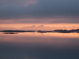
The Norwegian Sea is a marginal sea, grouped with either the Atlantic Ocean or the Arctic Ocean, northwest of Norway between the North Sea and the Greenland Sea, adjoining the Barents Sea to the northeast. In the southwest, it is separated from the Atlantic Ocean by a submarine ridge running between Iceland and the Faroe Islands. To the north, the Jan Mayen Ridge separates it from the Greenland Sea.

The Bering Sea is a marginal sea of the Northern Pacific Ocean. It forms, along with the Bering Strait, the divide between the two largest landmasses on Earth: Eurasia and the Americas. It comprises a deep water basin, which then rises through a narrow slope into the shallower water above the continental shelves. The Bering Sea is named after Vitus Bering, a Danish-born Russian navigator, who, in 1728, was the first European to systematically explore it, sailing from the Pacific Ocean northward to the Arctic Ocean.
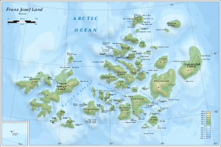
Franz Josef Land is a Russian archipelago in the Arctic Ocean. It is inhabited only by military personnel. It constitutes the northernmost part of Arkhangelsk Oblast and consists of 192 islands, which cover an area of 16,134 square kilometers (6,229 sq mi), stretching 375 kilometers (233 mi) from east to west and 234 kilometers (145 mi) from north to south. The islands are categorized in three groups separated by the British Channel and the Austrian Strait. The central group is further divided into a northern and southern section by the Markham Sound. The largest island is Prince George Land, which measures 2,741 square kilometers (1,058 sq mi), followed by Wilczek Land, Graham Bell Island and Alexandra Land.
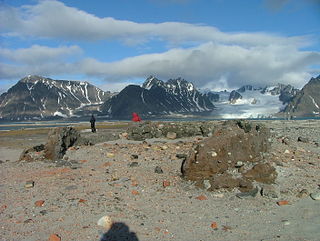
Smeerenburg was a whaling settlement on Amsterdam Island in northwest Svalbard. It was founded by the Danish and Dutch in 1619 as one of Europe's northernmost outposts. With the local bowhead whale population soon decimated and whaling developed into a pelagic industry, Smeerenburg was abandoned around 1660.

Baffin Bay, located between Baffin Island and the west coast of Greenland, is defined by the International Hydrographic Organization as a marginal sea of the Arctic Ocean. It is sometimes considered a sea of the North Atlantic Ocean. It is connected to the Atlantic via Davis Strait and the Labrador Sea. The narrower Nares Strait connects Baffin Bay with the Arctic Ocean. The bay is not navigable most of the year because of the ice cover and high density of floating ice and icebergs in the open areas. However, a polynya of about 80,000 km2 (31,000 sq mi), known as the North Water, opens in summer on the north near Smith Sound. Most of the aquatic life of the bay is concentrated near that region.
The polar archipelago of Svalbard was first discovered by Willem Barentsz in 1596, although there is disputed evidence of use by Pomors or Norsemen. Whaling for bowhead whales started in 1611, dominated by English and Dutch companies, though other countries participated. At that time there was no agreement about sovereignty. Whaling stations, the largest being Smeerenburg, were built during the 17th century, but gradually whaling decreased. Hunting was carried out from the 17th century by Pomors, but from the 19th century it became more dominated by Norwegians.

The Chukchi Sea, sometimes referred to as the Chuuk Sea, Chukotsk Sea or the Sea of Chukotsk, is a marginal sea of the Arctic Ocean. It is bounded on the west by the Long Strait, off Wrangel Island, and in the east by Point Barrow, Alaska, beyond which lies the Beaufort Sea. The Bering Strait forms its southernmost limit and connects it to the Bering Sea and the Pacific Ocean. The principal port on the Chukchi Sea is Uelen in Russia. The International Date Line crosses the Chukchi Sea from northwest to southeast. It is displaced eastwards to avoid Wrangel Island as well as the Chukotka Autonomous Okrug on the Russian mainland.
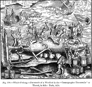
This article discusses the history of whaling from prehistoric times up to the commencement of the International Whaling Commission (IWC) moratorium on commercial whaling in 1986. Whaling has been an important subsistence and economic activity in multiple regions throughout human history. Commercial whaling dramatically reduced in importance during the 19th century due to the development of alternatives to whale oil for lighting, and the collapse in whale populations. Nevertheless, some nations continue to hunt whales even today.

The Greenland Sea is a body of water that borders Greenland to the west, the Svalbard archipelago to the east, Fram Strait and the Arctic Ocean to the north, and the Norwegian Sea and Iceland to the south. The Greenland Sea is often defined as part of the Arctic Ocean, sometimes as part of the Atlantic Ocean. However, definitions of the Arctic Ocean and its seas tend to be imprecise or arbitrary. In general usage the term "Arctic Ocean" would exclude the Greenland Sea. In oceanographic studies the Greenland Sea is considered part of the Nordic Seas, along with the Norwegian Sea. The Nordic Seas are the main connection between the Arctic and Atlantic oceans and, as such, could be of great significance in a possible shutdown of thermohaline circulation. In oceanography the Arctic Ocean and Nordic Seas are often referred to collectively as the "Arctic Mediterranean Sea", a marginal sea of the Atlantic.

Foxe Basin is a shallow oceanic basin north of Hudson Bay, in Nunavut, Canada, located between Baffin Island and the Melville Peninsula. For most of the year, it is blocked by sea ice and drift ice made up of multiple ice floes.

Billefjorden is the central fjord of the three branching from the innermost part of the Isfjorden to the northeast, in Svalbard, Norway. It is 30 km long and 5–8 km wide. Billefjorden lies between Dickson Land to the northwest and Bünsow Land in the southeast. Located on its northwestern shore is the former Russian coal mining community of Pyramiden. To the northeast is Nordenskiöldbreen. At its northeastern extreme is Adolf Bay.

The Arctic Ocean is the smallest and shallowest of the world's five oceanic divisions. It spans an area of approximately 14,060,000 km2 (5,430,000 sq mi) and is the coldest of the world's oceans. The International Hydrographic Organization (IHO) recognizes it as an ocean, although some oceanographers call it the Arctic Mediterranean Sea. It has also been described as an estuary of the Atlantic Ocean. It is also seen as the northernmost part of the all-encompassing world ocean.

The Fram Strait is the passage between Greenland and Svalbard, located roughly between 77°N and 81°N latitudes and centered on the prime meridian. The Greenland and Norwegian Seas lie south of Fram Strait, while the Nansen Basin of the Arctic Ocean lies to the north. Fram Strait is noted for being the only deep connection between the Arctic Ocean and the World Oceans. The dominant oceanographic features of the region are the West Spitsbergen Current on the east side of the strait and the East Greenland Current on the west.

The bowhead whale is a species of baleen whale belonging to the family Balaenidae and is the only living representative of the genus Balaena. It is the only baleen whale endemic to the Arctic and subarctic waters, and is named after its characteristic massive triangular skull, which it uses to break through Arctic ice. Other common names of the species included the Greenland right whale, Arctic whale, steeple-top, and polar whale.

The West Spitsbergen Current (WSC) is a warm, salty current that runs poleward just west of Spitsbergen,, in the Arctic Ocean. The WSC branches off the Norwegian Atlantic Current in the Norwegian Sea. The WSC is of importance because it drives warm and salty Atlantic Water into the interior Arctic. The warm and salty WSC flows north through the eastern side of Fram Strait, while the East Greenland Current (EGC) flows south through the western side of Fram Strait. The EGC is characterized by being very cold and low in salinity, but above all else it is a major exporter of Arctic sea ice. Thus, the EGC combined with the warm WSC makes the Fram Strait the northernmost ocean area having ice-free conditions throughout the year in all of the global ocean.
The Basques were among the first people to catch whales commercially rather than purely for subsistence and dominated the trade for five centuries, spreading to the far corners of the North Atlantic and even reaching the South Atlantic. The French explorer Samuel de Champlain, when writing about Basque whaling in Terranova, described them as "the cleverest men at this fishing". By the early 17th century, other nations entered the trade in earnest, seeking the Basques as tutors, "for [they] were then the only people who understand whaling", lamented the English explorer Jonas Poole.

The North Water Polynya (NOW), or Pikialasorsuaq to Inuit in Greenland and Sarvarjuaq to Inuit in Canada, is a polynya that lies between Greenland and Canada in northern Baffin Bay. The world's largest Arctic polynya at about 85,000 km2 (33,000 sq mi), it creates a warm microclimate that provides a refuge for narwhal, beluga, walrus, and bowhead whales to feed and rest. While thin ice forms in some areas, the polynya is kept open by wind, tides and an ice bridge on its northern edge. Named the "North Water" by 19th century whalers who relied on it for spring passage, this polynya is one of the most biologically productive marine areas in the Arctic Ocean.

Barrow Canyon is a submarine canyon that straddles the boundary between the Beaufort and Chukchi seas. Compared to other nearby areas and the Canada Basin, the highly productive Barrow Canyon supports a diversity of marine animals and invertebrates.
Whaling in Canada encompasses both aboriginal and commercial whaling, and has existed on all three Canadian oceans, Atlantic, Pacific, and Arctic. The indigenous peoples of the Pacific Northwest Coast have whaling traditions dating back millennia, and the hunting of cetaceans continues by Inuit. By the late 20th century, watching whales was a more profitable enterprise than hunting them.

Sue E. Moore is a scientist at the University of Washington known for her research on marine mammals in the Arctic.
