Cape Farewell, Greenland

Last updated
Cape Farewell
Nunap Isua
Greenland edcp location map.svg
Red pog.svg
Cape Farewell
Coordinates: 59°46′23″N43°55′21″W / 59.77306°N 43.92250°W / 59.77306; -43.92250
Location Kujalleq, Greenland
Offshore water bodies North Atlantic Ocean
Area
  Total Arctic

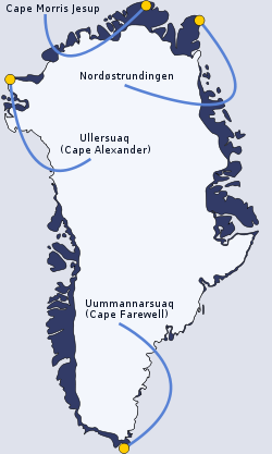
Cape Farewell (Greenlandic : Nunap Isua; [1] Danish : Kap Farvel) [2] is a headland on the southern shore of Egger Island, Nunap Isua Archipelago, Greenland. [3] As the southernmost point of the country, it is one of the important landmarks of Greenland.

Contents

Geography

Located at 59°46′23″N43°55′21″W / 59.77306°N 43.92250°W / 59.77306; -43.92250 , excluding small offshore islets, this cape is the southernmost extent of Greenland, projecting out into the North Atlantic Ocean and the Labrador Sea on the same latitude as St Petersburg, Oslo and the Shetland Islands. Egger and the associated minor islands are known as the Cape Farewell Archipelago. The area is part of the Kujalleq municipality. King Frederick VI Coast stretches from Cape Farewell to Pikiulleq Bay (former spelling 'Pikiutdleq') in the north along the eastern coast of Greenland.

Cape Farewell (in the centre of the image) and the rugged southern coast of Egger Island. The coast (dark) is generally surrounded by sea ice, making navigation treacherous. Cape farewell greenland landsat.jpg
Cape Farewell (in the centre of the image) and the rugged southern coast of Egger Island. The coast (dark) is generally surrounded by sea ice, making navigation treacherous.
Uummannarsuaq amongst the extreme points of Greenland Extreme-points-of-greenland.svg
Uummannarsuaq amongst the extreme points of Greenland

Climate

Climate data for Cape Farewell (Angissoq) (normals 1991-2020, extremes 1991-2020)
MonthJanFebMarAprMayJunJulAugSepOctNovDecYear
Record high °C (°F)9.6
(49.3)
9.3
(48.7)
9.3
(48.7)
12.0
(53.6)
14.3
(57.7)
14.1
(57.4)
16.1
(61.0)
16.0
(60.8)
15.0
(59.0)
13.8
(56.8)
11.2
(52.2)
9.7
(49.5)
16.1
(61.0)
Average high °C (°F)−1.1
(30.0)
−1.6
(29.1)
−0.9
(30.4)
1.5
(34.7)
3.5
(38.3)
5.4
(41.7)
6.7
(44.1)
7.2
(45.0)
6.2
(43.2)
3.9
(39.0)
1.7
(35.1)
0.1
(32.2)
2.7
(36.9)
Daily mean °C (°F)−2.8
(27.0)
−3.3
(26.1)
−2.5
(27.5)
−0.1
(31.8)
1.7
(35.1)
3.2
(37.8)
4.5
(40.1)
5.2
(41.4)
4.5
(40.1)
2.4
(36.3)
0.3
(32.5)
−1.4
(29.5)
1.0
(33.8)
Average low °C (°F)−4.4
(24.1)
−5.0
(23.0)
−4.2
(24.4)
−1.8
(28.8)
−0.2
(31.6)
1.0
(33.8)
2.2
(36.0)
3.3
(37.9)
2.9
(37.2)
1.0
(33.8)
−1.1
(30.0)
−2.8
(27.0)
−0.8
(30.6)
Record low °C (°F)−16.1
(3.0)
−15.9
(3.4)
−16.3
(2.7)
−9.5
(14.9)
−9.4
(15.1)
−5.1
(22.8)
−2.5
(27.5)
−2.8
(27.0)
−1.8
(28.8)
−6.2
(20.8)
−9.1
(15.6)
−13.0
(8.6)
−16.3
(2.7)
Average precipitation mm (inches)98
(3.9)
67
(2.6)
67
(2.6)
77
(3.0)
50
(2.0)
53
(2.1)
71
(2.8)
65
(2.6)
68
(2.7)
73
(2.9)
72
(2.8)
92
(3.6)
853
(33.6)
Average precipitation days (≥ 1.0 mm)15.211.612.112.48.86.16.67.97.28.48.313.5118.1
Source: Danish Meteorological Institute [4]

See also

Related Research Articles

<span class="mw-page-title-main">Geography of Greenland</span> Geography of the worlds largest island

Greenland is located between the Arctic Ocean and the North Atlantic Ocean, northeast of Canada and northwest of Iceland. The territory comprises the island of Greenland—the largest island in the world—and more than a hundred other smaller islands. Greenland has a 1.2 kilometre long border with Canada on Hans Island. A sparse population is confined to small settlements along certain sectors of the coast. Greenland possesses the world's second-largest ice sheet.

<span class="mw-page-title-main">Ellesmere Island</span> Island of the Arctic Archipelago in Nunavut, Canada

Ellesmere Island is Canada's northernmost and third largest island, and the tenth largest in the world. It comprises an area of 196,236 km2 (75,767 sq mi), slightly smaller than Great Britain, and the total length of the island is 830 km (520 mi).

<span class="mw-page-title-main">Upernavik</span> Place in Greenland, Kingdom of Denmark

Upernavik is a small town in the Avannaata municipality in northwestern Greenland, located on a small island of the same name. With 1,092 inhabitants as of 2020, it is the twelfth-largest town in Greenland. It contains the Upernavik Museum.

<span class="mw-page-title-main">Baffin Bay</span> Marginal sea between Greenland and Baffin Island, Canada

Baffin Bay, located between Baffin Island and the west coast of Greenland, is defined by the International Hydrographic Organization as a marginal sea of the Arctic Ocean. It is sometimes considered a sea of the North Atlantic Ocean. It is connected to the Atlantic via Davis Strait and the Labrador Sea. The narrower Nares Strait connects Baffin Bay with the Arctic Ocean. The bay is not navigable most of the year because of the ice cover and high density of floating ice and icebergs in the open areas. However, a polynya of about 80,000 km2 (31,000 sq mi), known as the North Water, opens in summer on the north near Smith Sound. Most of the aquatic life of the bay is concentrated near that region.

This article lists extreme locations on Earth that hold geographical records or are otherwise known for their geophysical or meteorological superlatives. All of these locations are Earth-wide extremes; extremes of individual continents or countries are not listed.

The extreme points of Norway include the coordinates that are farther north, south, east or west than any other location in Norway; and the highest and the lowest altitudes in the country. The northernmost point is Rossøya on Svalbard, the southernmost is Pysen in Mandal, the easternmost is Kræmerpynten on Svalbard, and the westernmost is Hoybergodden on Jan Mayen. The highest peak is Galdhøpiggen, standing at 2,469 m (8,100 ft) above mean sea level, while the lowest elevation is sea level at the coast.

<span class="mw-page-title-main">Greenland Sea</span> Body of water

The Greenland Sea is a body of water that borders Greenland to the west, the Svalbard archipelago to the east, Fram Strait and the Arctic Ocean to the north, and the Norwegian Sea and Iceland to the south. The Greenland Sea is often defined as part of the Arctic Ocean, sometimes as part of the Atlantic Ocean. However, definitions of the Arctic Ocean and its seas tend to be imprecise or arbitrary. In general usage the term "Arctic Ocean" would exclude the Greenland Sea. In oceanographic studies the Greenland Sea is considered part of the Nordic Seas, along with the Norwegian Sea. The Nordic Seas are the main connection between the Arctic and Atlantic oceans and, as such, could be of great significance in a possible shutdown of thermohaline circulation. In oceanography the Arctic Ocean and Nordic Seas are often referred to collectively as the "Arctic Mediterranean Sea", a marginal sea of the Atlantic.

<span class="mw-page-title-main">Nanortalik</span> Place in Greenland, Kingdom of Denmark

Nanortalik, formerly Nennortalik, is a town in Nanortalik Island, Kujalleq municipality, southern Greenland. With 1,185 inhabitants as of 2020, it is the eleventh-largest town in the country. The name Nanortalik means "Place of Polar Bears" or "Place Where the Polar Bears Go". It is the southernmost town in Greenland with a population of over 1,000.

<span class="mw-page-title-main">Sammisoq</span>

Sammisoq is an island in the Kujalleq municipality in southern Greenland, located northeast of Uummannarsuaq cape. It is the largest island of the Cape Farewell Archipelago.

<span class="mw-page-title-main">Kulusuk Island</span>

Kulusuk Island is an island in the Sermersooq municipality on the southeastern shore of Greenland. It is an outlying island in the Ammassalik archipelago of islands on the coast of the North Atlantic. The island is home to Kulusuk, the fourth-largest settlement on the entire eastern coast of Greenland. The island has an area of 41.98 km2, and measures 8 km (5.0 mi) from north to south and 11 km (6.8 mi) from west to east. The Kulusuk Airport on the island is one of the two airports on the entire eastern Greenland coast.

Ikeq is an island of the Kujalleq municipality, southern Greenland.

<span class="mw-page-title-main">Borders of the oceans</span> Limits of Earths oceanic waters

The borders of the oceans are the limits of Earth's oceanic waters. The definition and number of oceans can vary depending on the adopted criteria. The principal divisions of the five oceans are the Pacific Ocean, Atlantic Ocean, Indian Ocean, Southern (Antarctic) Ocean, and Arctic Ocean. Smaller regions of the oceans are called seas, gulfs, bays, straits, and other terms. Geologically, an ocean is an area of oceanic crust covered by water.

<span class="mw-page-title-main">Prince Christian Sound</span> Waterway in Greenland

The Prince Christian Sound is a waterway in Southern Greenland. It separates the mainland from Sammisoq and other islands of the Cape Farewell Archipelago near the southernmost tip of Greenland. The name was given in honour of the prince, later king Christian VIII of Denmark.

<span class="mw-page-title-main">Cape Farewell Archipelago</span> Archipelago at the southern end of Greenland

Cape Farewell Archipelago is an island group located at the southern end of Greenland in Kujalleq municipality. The archipelago takes its name from Cape Farewell, a headland of Egger Island.

<span class="mw-page-title-main">Tunumiit</span> Group of Greenlandic Inuit

Iivit or Tunumiit are Indigenous Greenlandic Inuit from Iivi Nunaa, Tunu in the area of Kangikajik and Ammassalik, the eastern part of Inuit Nunaat. The Iivit live now mainly in Tasiilaq and Ittoqqortoormiit and are a part of the Arctic people known collectively as the Inuit. The singular for Iivit is Iik or for Tunumiit version it is Tunumiu.

Napasorsuaq Fjord or Napasorsuup Kangerlua is a fjord of the King Frederick VI Coast in the Sermersooq municipality, southeastern Greenland.

Paatusoq, mentioned as 'Patursok' by Wilhelm August Graah, is a fjord in the King Frederick VI Coast, Kujalleq municipality, southeastern Greenland. Its name means "The one with the big mouth" in the Greenlandic language.

<span class="mw-page-title-main">Egger Island</span> Island in Greenland

Egger Island is Greenland's southernmost island. It is located in the Kujalleq municipality and is uninhabited.

References

  1. "Den grønlandske Lods - Geodatastyrelsen" (PDF). Archived from the original (PDF) on 2020-10-28. Retrieved 2016-05-06.
  2. "Cape Farewell". Geonames. Retrieved 6 May 2016.
  3. Cape Farewell
  4. "Climatological Standard Normals 1991-2020 Greenland" (PDF). DMI. Retrieved 2023-03-01.