The Gulf of Alaska is an arm of the Pacific Ocean defined by the curve of the southern coast of Alaska, stretching from the Alaska Peninsula and Kodiak Island in the west to the Alexander Archipelago in the east, where Glacier Bay and the Inside Passage are found.
Cape Farewell is a headland on the southern shore of Egger Island, Nunap Isua Archipelago, Greenland. As the southernmost point of the country, it is one of the important landmarks of Greenland.
Wolstenholme Fjord is a fjord in Avannaata municipality, Northwest Greenland. It is located to the north of the Thule Air Base and adjacent to the abandoned Inuit settlement of Narsaarsuk.
Sammisoq is an island in the Kujalleq municipality in southern Greenland, located northeast of Uummannarsuaq cape. It is the largest island of the Cape Farewell Archipelago.
Ikeq is an island of the Kujalleq municipality, southern Greenland.
Avallersuaq, old spelling Avatdlerssuaq, is an uninhabited island of the Cape Farewell Archipelago in Kujalleq municipality of southern Greenland.
Kitak is an island in the Sermersooq municipality in southeastern Greenland.
Kitsissut is an island group in the Kujalleq municipality in southern Greenland.
Cape Nansen is a headland in the Greenland Sea, east Greenland, Sermersooq municipality. This cape is named after Fridtjof Nansen. Cape Nansen is an important geographical landmark.
Nanuuseq, also known as Nanûseq or Nanusek is an uninhabited island in the Kujalleq municipality in southern Greenland.

King Frederick VI Coast is a major geographic division of Greenland. It comprises the coastal area of Southeastern Greenland in Sermersooq and Kujalleq municipalities fronting the Irminger Sea of the North Atlantic Ocean. It is bordered by King Christian IX Land on the north and the Greenland Ice Sheet to the west.
Torsukattak is a fjord in far southern Greenland. Administratively it is part of the Kujalleq municipality.
Kangerluluk, meaning 'the awful fjord', is a fjord in the King Frederick VI Coast, Kujalleq municipality, southern Greenland.
Ingolf Fjord, also known as Ingolf Sound, is a fjord of Greenland's northeastern coast in northern King Frederick VIII Land.

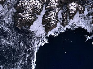
Egger Island is Greenland's southernmost island. It is located in the Kujalleq municipality and is uninhabited.
Igtip Kangertiva, also known as Comanche Bay. is a fjord in Eastern Greenland. It is part of the Sermersooq municipality.

Bjorne Island, Danish: Bjørneø, meaning 'Bear Island', is an island in NE Greenland. Administratively it belongs to the Northeast Greenland National Park.

Geologfjord is a fjord in King Christian X Land, East Greenland. Administratively it belongs to the Northeast Greenland National Park.

Young Sound is a marine channel with a fjord structure in King Christian X Land, East Greenland. Administratively it is part of the Northeast Greenland National Park zone.
Kjerulf Fjord is a fjord in King Christian X Land, eastern Greenland.