Prince Christian Sound

Last updated
Prince Christian Sound
Prins Christian Sund.jpg
Greenland edcp relief location map.jpg
Red pog.svg
Prince Christian Sound
Location in Greenland
Location Arctic (S Greenland)
Coordinates 60°9′N43°53′W / 60.150°N 43.883°W / 60.150; -43.883
Native nameIkerasassuaq (Greenlandic)
Ocean/sea sources Labrador Sea / Irminger Sea
(North Atlantic Ocean)
Basin  countries Greenland
Max. length100 km (62 mi)
Max. width2.7 km (1.7 mi)

The Prince Christian Sound (Greenlandic: Ikerasassuaq; [1] Danish:Prins Christians Sund) is a waterway in Southern Greenland. It separates the mainland from Sammisoq (Christian IV Island) and other islands of the Cape Farewell Archipelago near the southernmost tip of Greenland. The name was given in honour of the prince, later king Christian VIII of Denmark. [2]

Contents

Geography

Prince Christian Sound

The Prince Christian Sound connects the Labrador Sea with the Irminger Sea. It is around 100 km (60 miles) long and it is narrow, sometimes only 500 metres (1,600 ft) wide. There is only one settlement along this sound, Aappilattoq.

The long fjord system is mostly surrounded by steep mountains in general reaching over 1,200 metres (3,900 ft), one of them 2,220 metres (7,280 ft) high [3] [4] Many glaciers go straight into its waters where they calve icebergs. There are often strong tidal currents limiting the formation of ice. It has many offshoots, such as Kangerluk to the north midway through the fjord, Ikeq Fjord in the south, and in the west Ilua Fjord, Ikerasaq Fjord (Akuliarutsip Imaa), Utoqqarmiut Fjord (Pamialluup Kujatinngua) and the Torsukattak Fjord. [5]

View of the shore. Nunataker hg.jpg
View of the shore.
Head of a glacier Prinz-christian-sund glacier hg.jpg
Head of a glacier

Weather station

At the entrance to the East to the Strait ( 60°03′N43°10′W / 60.050°N 43.167°W / 60.050; -43.167 ) there is a weather station founded by the US during World War II under the name Bluie East One. The task of the weather station was to ensure that the shipping industry had reliable data on the weather at Cape Farewell, Greenland. On January 7, 1959, when the ship MS Hans Hedtoft hit an iceberg at Cape Farvel, the radio telegraphist at the weather station at Prince Christian Sound was the first to catch the ship's distress signal.

The weather station is today run by the International Civil Aviation Organization ICAO together with Tele Greenland. A long wooden stairway leads from the harbour up to the station with community building, power plant, residential barracks and radio aerial plants.

Tourism

The scenery of Prince Christian Sound attracts summer cruise ships to the area, with some vessels as large as the 86,700 ton Eurodam, [6] or the 137,000 ton Voyager of the Seas [7] Ships must go slowly due to the icebergs.

Climate

Prince Christian Sound has a maritime polar climate (Köppen ET) making borderline with subpolar oceanic climate (Cfc) due low annual temperature swings for its latitude and relatively high temperature in center months. Summer temperatures are way below the tree line requirements, whereas the long winters are comparatively mild for its high latitude. The nearby ice sheet produces cold air which keeps summer temperatures down.[ citation needed ]

Climate data for Prince Christian Sound 1961-1990, extremes 1958-1999
MonthJanFebMarAprMayJunJulAugSepOctNovDecYear
Record high °C (°F)7.5
(45.5)
9.0
(48.2)
9.0
(48.2)
11.6
(52.9)
14.0
(57.2)
20.0
(68.0)
24.2
(75.6)
20.9
(69.6)
20.0
(68.0)
14.2
(57.6)
9.8
(49.6)
13.4
(56.1)
24.2
(75.6)
Average high °C (°F)−1.9
(28.6)
−1.8
(28.8)
−1.3
(29.7)
1.5
(34.7)
4.4
(39.9)
7.3
(45.1)
9.8
(49.6)
9.6
(49.3)
6.9
(44.4)
3.5
(38.3)
0.6
(33.1)
−0.9
(30.4)
3.1
(37.7)
Daily mean °C (°F)−4.1
(24.6)
−3.9
(25.0)
−3.7
(25.3)
−0.9
(30.4)
1.9
(35.4)
4.5
(40.1)
6.5
(43.7)
6.5
(43.7)
4.3
(39.7)
1.4
(34.5)
−1.3
(29.7)
−3.2
(26.2)
0.7
(33.2)
Average low °C (°F)−6.2
(20.8)
−6.3
(20.7)
−5.9
(21.4)
−3.5
(25.7)
−0.6
(30.9)
1.2
(34.2)
3.3
(37.9)
3.3
(37.9)
1.9
(35.4)
−0.7
(30.7)
−3.4
(25.9)
−5.1
(22.8)
−1.8
(28.7)
Record low °C (°F)−20.0
(−4.0)
−16.0
(3.2)
−16.9
(1.6)
−15.2
(4.6)
−10.2
(13.6)
−5.5
(22.1)
−3.6
(25.5)
−3.5
(25.7)
−3.2
(26.2)
−6.9
(19.6)
−12.0
(10.4)
−15.3
(4.5)
−20.0
(−4.0)
Average precipitation mm (inches)262
(10.3)
246
(9.7)
205
(8.1)
227
(8.9)
175
(6.9)
136
(5.4)
129
(5.1)
173
(6.8)
233
(9.2)
219
(8.6)
227
(8.9)
251
(9.9)
2,483
(97.8)
Average precipitation days (≥ 1 mm)15.915.614.114.212.510.010.510.412.712.713.015.1156.7
Average snowy days16.615.815.013.67.81.80.20.13.09.113.514.6111.1
Source: DMI

See also

Related Research Articles

<span class="mw-page-title-main">Geography of Greenland</span> Geography of the worlds largest island

Greenland is located between the Arctic Ocean and the North Atlantic Ocean, northeast of Canada and northwest of Iceland. The territory comprises the island of Greenland—the largest island in the world—and more than a hundred other smaller islands. Greenland has a 1.2 kilometre long border with Canada on Hans Island. A sparse population is confined to small settlements along certain sectors of the coast. Greenland possesses the world's second-largest ice sheet.

<span class="mw-page-title-main">Scoresby Sound</span>

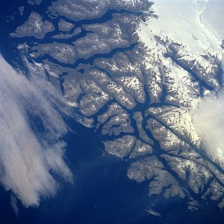
Scoresby Sound is a large fjord system of the Greenland Sea on the eastern coast of Greenland. It has a tree-like structure, with a main body approximately 110 km (68 mi) long that branches into a system of fjords covering an area of about 38,000 km2 (14,700 sq mi). The longest of the fjords extends 340–350 km (210-216 mi) inland from the coastline. The depth is 400–600 m (1,310-1,970 ft) in the main basin, but depths increase to up to 1,450 m (4,760 ft) in some fjords. It is one of the largest and longest fjord systems in the world.

<span class="mw-page-title-main">Danmark Fjord</span>

Danmark Fjord, also known as Denmark Sound, is a fjord in northeast Greenland. Administratively it belongs to the Northeast Greenland National Park.

<span class="mw-page-title-main">Nanortalik</span> Place in Greenland, Kingdom of Denmark

Nanortalik, formerly Nennortalik, is a town in Nanortalik Island, Kujalleq municipality, southern Greenland. With 1,185 inhabitants as of 2020, it is the eleventh-largest town in the country. The name Nanortalik means "Place of Polar Bears" or "Place Where the Polar Bears Go". It is the southernmost town in Greenland with a population of over 1,000.

<span class="mw-page-title-main">Aappilattoq, Kujalleq</span> Place in Greenland, Kingdom of Denmark

Aappilattoq is a village in the Kujalleq municipality in southern Greenland. The name means "red", after the red mountain rising above the settlement in the Greenlandic language. The settlement had 100 inhabitants in 2020.

<span class="mw-page-title-main">Kulusuk</span> Place in Greenland, Kingdom of Denmark

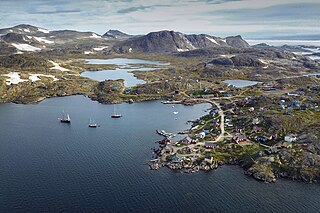
Kulusuk, formerly Kap Dan, is a settlement in the Sermersooq municipality in southeastern Greenland, located on an island of the same name. The settlement population of 241 includes many Danes choosing to live there due to the airport. In the Kalaallisut language, the name of the village means "Chest of a Black Guillemot".

<span class="mw-page-title-main">Sammisoq</span>

Sammisoq is an island in the Kujalleq municipality in southern Greenland, located northeast of Uummannarsuaq cape. It is the largest island of the Cape Farewell Archipelago.

<span class="mw-page-title-main">Clavering Island</span> Island on the east coast of Greenland

Clavering Island is a large island in eastern Greenland off Gael Hamke Bay, to the south of Wollaston Foreland.

<span class="mw-page-title-main">Bluie</span> WWII United States military code name for Greenland

Bluie was the United States military code name for Greenland during World War II. It is remembered by the numbered sequence of base locations identified by the 1941 United States Coast Guard South Greenland Survey Expedition, and subsequently used in radio communications by airmen unfamiliar with pronunciation of the Greenlandic Inuit and Danish names of those locations. These were typically spoken BLUIE (direction) (number), with direction being east or west along the Greenland coast from Cape Farewell.

<span class="mw-page-title-main">Petermann Glacier</span> Glacier in Greenland

Petermann Glacier is a large glacier located in North-West Greenland to the east of Nares Strait. It connects the Greenland ice sheet to the Arctic Ocean at 81°10' north latitude, near Hans Island.

<span class="mw-page-title-main">Kangerlussuaq Fjord, East Greenland</span>

Kangerlussuaq Fjord is a fjord in eastern Greenland. It is part of the Sermersooq municipality.

<span class="mw-page-title-main">Umivik Bay</span>

Umivik Bay, also known as Umiivik and Umerik, is a bay in King Frederick VI Coast, southeastern Greenland. It is part of the Sermersooq municipality.

<span class="mw-page-title-main">Denmark expedition</span>

The Denmark expedition, also known as the Denmark Expedition to Greenland's Northeast Coast, and as the Danmark Expedition after the ship, was an expedition to the northeast of Greenland in 1906–1908. Despite being overshadowed by the death in tragic circumstances of the main exploration team, including three of the expedition's leading members: Ludvig Mylius-Erichsen (1872–1907), Niels Peter Høeg Hagen (1877–1907) and Jørgen Brønlund (1877–1907), the Denmark expedition was not a failure. It achieved its main cartographic objectives and succeeded in exploring the vast region, drawing accurate charts of formerly unexplored coastlines and fjords, naming numerous geographic features, and gathering a wealth of scientific data.

<span class="mw-page-title-main">Antarctic Sound, Greenland</span>

The Antarctic Sound is a sound in King Christian X Land, Northeast Greenland. Administratively it is part of the Northeast Greenland National Park zone.

<span class="mw-page-title-main">Nordvestfjord</span> Fjord in Greenland

Nordvestfjord, meaning 'Northwest Fjord', is a fjord in King Christian X Land, eastern Greenland.

<span class="mw-page-title-main">Gaasefjord</span>

Gaasefjord is a fjord in King Christian X Land, eastern Greenland. This fjord is part of the Scoresby Sound system. Administratively it lies in the area of Sermersooq municipality.

<span class="mw-page-title-main">Dijmphna Sound</span> Strait in Greenland

The Dijmphna Sound is a sound in King Frederick VIII Land, Northeast Greenland. Administratively it is part of the Northeast Greenland National Park zone.

<span class="mw-page-title-main">Fonfjord</span>

Fonfjord is a fjord in King Christian X Land, eastern Greenland. This fjord is part of the Scoresby Sound system. Administratively it lies in the area of Sermersooq municipality.

Hurry Inlet is a fjord in King Christian X Land, eastern Greenland. This fjord is part of the Scoresby Sound system. Administratively it lies in the area of Sermersooq municipality.

<span class="mw-page-title-main">Davy Sound</span>

The Davy Sound is a sound in King Christian X Land, Northeast Greenland. Administratively it is part of the Northeast Greenland National Park zone.

References

  1. Den grønlandske Lods - Geodatastyrelsen
  2. Prins Christian Sund (Den Store Danske Leksikon) (in Danish)
  3. Wiles, Andrew (2016). Arctic and Northern Waters (Revised first ed.). St Ives: Imray Laurie Norie & Wilson LTD. p. 224. ISBN   978 184623 828 4.
  4. See OpenStreetMap at 60°23′26″N44°00′06″W / 60.3906°N 44.0016°W .
  5. "Torsukattak". Mapcarta. Retrieved 8 April 2016.
  6. Scenic Cruising on Eurodam
  7. "Voyager Of The Seas In Prins Christians Sund Greenland - Oakland Travel". youtube. 2022-09-14. Retrieved 2022-10-16.