Robert Edwin Peary Sr. was an American explorer and officer in the United States Navy who made several expeditions to the Arctic in the late 19th and early 20th centuries. He was long credited as being the discoverer of the geographic North Pole in April 1909, having led the first expedition to have claimed this achievement, although it is now considered unlikely that he actually reached the Pole.

Ellesmere Island is Canada's northernmost and third largest island, and the tenth largest in the world. It comprises an area of 196,236 km2 (75,767 sq mi), slightly smaller than Great Britain, and the total length of the island is 830 km (520 mi).

Qaanaaq, formerly known as Thule or New Thule, is the main town in the northern part of the Avannaata municipality in northwestern Greenland. The town has a population of 646 as of 2020. The population was forcibly relocated from its former, traditional home, which was expropriated for the construction of a United States Air Force base in 1953. The inhabitants of Qaanaaq speak the local Inuktun language and many also speak Kalaallisut and Danish.
Cape York is a cape on the northwestern coast of Greenland, in northern Baffin Bay.
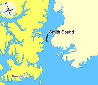
Smith Sound is an Arctic sea passage between Greenland and Nunavut's northernmost island, Ellesmere Island. It links Baffin Bay with Kane Basin and forms part of the Nares Strait. On the Canadian side it extends from Cape Sabine in the north to Cape Isabella in the south.

Nuussuaq, formerly Kraulshavn, is a settlement in Avannaata municipality in northwestern Greenland. It is the only mainland settlement in the Upernavik Archipelago, located near the western tip of the Nuussuaq Peninsula, on the northern coast of Sugar Loaf Bay, an indentation of Baffin Bay.
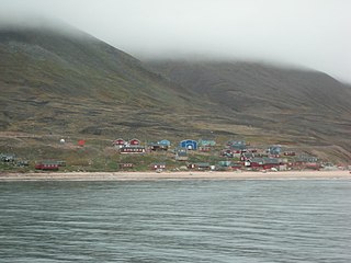
Siorapaluk or Hiurapaluk is a settlement in the Qaanaaq area of the Avannaata municipality in northern Greenland. The settlement is located in the northern shore of the Siorapaluup Kangerlua. It has a population of 43 who speak the Inuktun language of the Polar Inuit as well as the Kalaallisut dialect of Greenlandic. Many of the inhabitants are direct descendants of the last migration of Inuit from Canada in the 20th century.

Harry Whitney was an American sportsman, adventurer, and author. He traveled to northern Greenland with Robert Peary in 1908, staying over the winter with the Inughuit at Etah and Annoatok. In the spring of 1909 Whitney found himself at the center of the controversy between Frederick Cook and Peary over who had reached the North Pole first. A year after his return, he published a book on the trip. He is sometimes confused with his contemporary Harry Payne Whitney, who was no relation.

The Arctic Cordillera is a terrestrial ecozone in northern Canada characterized by a vast, deeply dissected chain of mountain ranges extending along the northeastern flank of the Canadian Arctic Archipelago from Ellesmere Island to the northeasternmost part of the Labrador Peninsula in northern Labrador and northern Quebec, Canada. It spans most of the eastern coast of Nunavut with high glaciated peaks rising through ice fields and some of Canada's largest ice caps, including the Penny Ice Cap on Baffin Island. It is bounded to the east by Baffin Bay, Davis Strait and the Labrador Sea while its northern portion is bounded by the Arctic Ocean.

The British Arctic Expedition of 1875–1876, led by Sir George Nares, was sent by the British Admiralty to attempt to reach the North Pole via Smith Sound on the west coast of Greenland.

The Inughuit, or the Smith Sound Inuit, historically Arctic Highlanders or Polar Eskimos, are an ethnic subgroup of the Greenlandic Inuit. They are the northernmost group of Inuit and the northernmost people in North America, living in Greenland. Inughuit make up about 1% of the population of Greenland.

The MacGregor Arctic Expedition was a privately funded expedition which set out to reoccupy Fort Conger, Ellesmere Island, Canada, a site within flying distance of the North Pole. The expedition, which took place from July 1, 1937, to October 3, 1938, had four main objectives: To collect weather data; to make a magnetic survey; to photograph the aurora borealis and study its effects upon radio transmission; and to explore the area northwest of Ellesmere Island, in order to clear up the questions about Crocker Land, which Robert Peary placed on the map more than 30 years earlier.
Qaanaaq Municipality was the only municipality in the county of North Greenland (Avannaa). It is now part of the municipality of Avannaata.

The Björling–Kallstenius Expedition was an ill-fated, Arctic expedition led by Swedish naturalists Alfred Björling (1871-1892) and Evald Kallstenius (1868-1892). Their aim was to be the first to reach the North Pole. The expedition ended in disaster, with the deaths of the five member crew.
David Haig-Thomas was a British ornithologist, wildlife photographer, explorer, and rower who competed for Great Britain in the 1932 Summer Olympics. He was an army commando during the Second World War and was killed in action during the Normandy Landings. Haig-Thomas Island in the Canadian Arctic is named after him.
Upernavik Archipelago is a vast coastal archipelago in the Avannaata municipality in northwestern Greenland, off the shores of northeastern Baffin Bay. The archipelago extends from the northwestern coast of Sigguup Nunaa peninsula in the south at approximately 71°50′N56°00′W to the southern end of Melville Bay in the north at approximately 74°50′N57°30′W.
Foulk Fjord is a fjord in Avannaata municipality in northwestern Greenland.

Inglefield Gulf or Inglefield Fjord is a fjord in northwestern Greenland. To the west, the fjord opens into the Baffin Bay. Administratively it belongs to the Avannaata municipality.

The Roosevelt Range or Roosevelt Mountains is a mountain range in Northern Greenland. Administratively this range is part of the Northeast Greenland National Park. Its highest peak is the highest point in Peary Land.