The City of David is an Israeli settlement and the archaeological site which is speculated to compose the original urban core of ancient Jerusalem. First suggested in 1920, the name was used officially from the 1970s, following the capture of East Jerusalem by Israel, but today the name is questioned in the archaeological academic community. In 1997 management of the park was taken over by Ir David Foundation. Although it is located within the Jerusalem Municipality, it is considered a settlement, having been built on land in the West Bank that was occupied by and annexed to Israel following the 1967 Six-Day War and 1980 Jerusalem Law. The international community regards Israeli settlements illegal under international law, although Israel disputes this. It is best known for its Iron Age structures attributed to Judean kings, and it also contains older Canaanite infrastructure dated to the Middle Bronze Age.

Upernavik is a small town in the Avannaata municipality in northwestern Greenland, located on a small island of the same name. With 1,055 inhabitants as of 2017, it is the thirteenth-largest town in Greenland. Owing to the small size of the settlement, everything is within walking distance. It contains the Upernavik Museum. It is the northern-most town in Greenland with a population of over 1,000.

MOLA is an archaeology and built heritage practice and independent charitable company registered with the Chartered Institute for Archaeologists (CIfA), providing a wide range of professional archaeological services to clients in London and across the country. It is one of the largest archaeological service providers in the UK, and is the only one with IRO status.

Wood Quay is a riverside area of Dublin that was a site of Viking settlement. The site is bounded on the north side by Wood Quay on the River Liffey, on the west by Winetavern Street, on the south by John's Lane and on the east by Fishamble Street.
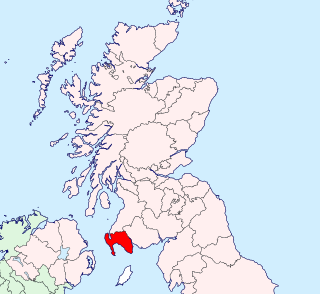
Wigtownshire or the County of Wigtown is a historic county, registration county and lieutenancy area in south-west Scotland. Until 1975, Wigtownshire was one of the administrative counties used for local government purposes, and is now administered as part of the council area of Dumfries and Galloway. As a lieutenancy area, Wigtownshire has its own Lord Lieutenant, currently John Alexander Ross. In the 19th century, it was also called West Galloway.
Durnovaria is the Latin form of the Brythonic name for the Roman town of Dorchester in the modern English county of Dorset. The first element in the name *durno- may mean "fist" the second may be related to Old Irish fáir ~ fóir denoting a confined area or den. Another and more consistently Brythonic derivation might be from "Fawr" Welsh meaning 'great' hence 'great fist'.
Jens Munk Island is one of the Canadian arctic islands in Qikiqtaaluk Region, Nunavut, Canada. It is an uninhabited Baffin Island offshore island. Located at 69°39'N 80°04'W it has an area of 920 km2 (360 sq mi).

Merthyr Mawr is a village and community in Bridgend, Wales. The village is about 2½ miles from the centre of Bridgend town. The population of the community at the 2011 census was 267. The community occupies the area west of the Ewenny River, between Bridgend and Porthcawl. It takes in the settlement of Tythegston and a stretch of coastal sand dunes known as Merthyr Mawr Warren.

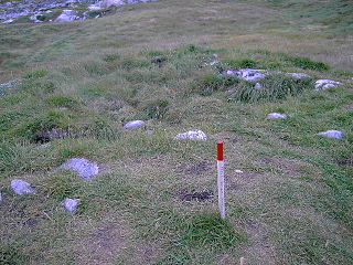
Poundbury Hill hill fort is the site of a Middle Bronze Age enclosure. It is roughly rectangular and it is likely that it was designed to command views over the River Frome and the Frome valley to the north. The main entrance to the fort is on the eastern end. It overlooks the county town of Dorchester, Dorset, England.
Verlamion, or Verlamio, was a settlement in Iron Age Britain. It was the centre of Tasciovanus' power and a major center of the Catuvellauni from about 20 BC until shortly after the Roman invasion of AD 43. Its location was on Prae Hill, 2 km to the west of modern St Albans.
Mucking is a hamlet and former Church of England parish adjoining the Thames Estuary in southern Essex, England. It is located approximately 2 miles south of the town of Stanford-le-Hope in what is now Thurrock unitary authority.
Monte Polizzo is an archaeological site located 6 km northwest of the town of Salemi, in the province of Trapani, western Sicily, southern Italy. It occupies an easily defended hilltop, from which a vast area of western Sicily can be seen, and consists of an interconnected group of ridges, the highest point of which is 725.9 m (2359 feet) above sea level. The settlement has been dated to c. 9th - 4th centuries BC.
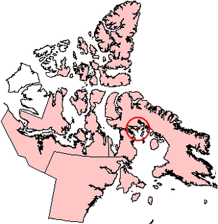
Based on archeological finds, Brooman Point Village is an abandoned village in Qikiqtaaluk Region, Nunavut, Canada. It is located in the central High Arctic on a point of the Gregory Peninsula, part of the eastern coast of Bathurst Island. Brooman was both a Late Dorset culture Paleo-Eskimo village as well as an Early Thule culture village. Both the artifacts and the architecture, specifically longhouses, are considered important historical remains of the two cultures. The site shows traces of Palaeo-Eskimo occupations between about 2000 BC and 1 AD, but the major prehistoric settlement occurred from about 900 to 1200 AD.
Kreamer Island is a small island in the south-easternmost part of Lake Okeechobee, located in Palm Beach County, Florida just north of Torry Island. Kreamer Island is accessible only by airboat during the wet season and by recreational vehicles during dry season/droughts. A small canal separates Kreamer Island and Torry Island.

Upernavik Archipelago is a vast coastal archipelago in the Avannaata municipality in northwestern Greenland, off the shores of northeastern Baffin Bay. The archipelago extends from the northwestern coast of Sigguup Nunaa peninsula in the south at approximately 71°50′N56°00′W to the southern end of Melville Bay in the north at approximately 74°50′N57°30′W.
The Cunetio Hoard, also known as the Mildenhall Hoard, is the largest hoard of Roman coins found in Britain. It was discovered in 1978 at the site of the Roman town of Cunetio, near modern-day Mildenhall, Wiltshire, and consisted of 54,951 low value coins. The coins were contained in a large pot and a lead container. The coins are now in the British Museum and the pot is on display at the Wiltshire Museum in Devizes.

Knud Rasmussen's Museum is a museum dedicated to the famous Danish explorer Knud Rasmussen. It is located in the town of Ilulissat, Greenland.

Port and Harbour of Ilulissat is an atlantic port located in the Disko Bay at Ilulissat, Greenland. Accessible most of the year, it is operated by Royal Arctic Line, Arctic Umiaq Line and Royal Greenland.