Annoatok
Location within Greenland
Annoatok or Anoritooq, located at 78°31′28.2″N72°24′10.8″W / 78.524500°N 72.403000°W , [1] was a small hunting station in Greenland on Smith Sound about 24 km (15 mi) north of Etah. It is now abandoned.
Annoatok or Anoritooq, located at 78°31′28.2″N72°24′10.8″W / 78.524500°N 72.403000°W , [1] was a small hunting station in Greenland on Smith Sound about 24 km (15 mi) north of Etah. It is now abandoned.
Annoatok was used as a base by Frederick Cook during his Arctic expedition of 1908–09, when he claimed to have reached the North Pole. [2] The name Annoatok means "the wind-loved place". [3] According to a publication in 1997 it was the most northerly inhabited place on Earth at that time. [4] However, excavations carried out by Eric Holtved in Inuarfissuaq at 78.9° N in central Inglefield Land proved human settlement even farther north. Excavations during the years 2004 to 2005 gave evidence of an ancient settlement about 30 km farther north in Qaqaitsut at 79.2° N in Eastern Inglefield Land. [5]

The North Pole, also known as the Geographic North Pole, Terrestrial North Pole or 90th Parallel North, is the point in the Northern Hemisphere where the Earth's axis of rotation meets its surface. It is called the True North Pole to distinguish from the Magnetic North Pole.

Robert Edwin Peary Sr. was an American explorer and officer in the United States Navy who made several expeditions to the Arctic in the late 19th and early 20th centuries. He was long credited as being the discoverer of the geographic North Pole in April 1909, having led the first expedition to have claimed this achievement, although it is now considered unlikely that he actually reached the Pole.

Ellesmere Island is Canada's northernmost and third largest island, and the tenth largest in the world. It comprises an area of 196,236 km2 (75,767 sq mi), slightly smaller than Great Britain, and the total length of the island is 830 km (520 mi).

Baffin Bay, located between Baffin Island and the west coast of Greenland, is defined by the International Hydrographic Organization as a marginal sea of the Arctic Ocean. It is sometimes considered a sea of the North Atlantic Ocean. It is connected to the Atlantic via Davis Strait and the Labrador Sea. The narrower Nares Strait connects Baffin Bay with the Arctic Ocean. The bay is not navigable most of the year because of the ice cover and high density of floating ice and icebergs in the open areas. However, a polynya of about 80,000 km2 (31,000 sq mi), known as the North Water, opens in summer on the north near Smith Sound. Most of the aquatic life of the bay is concentrated near that region.

Frederick Albert Cook was an American explorer, physician and ethnographer, who is most known for allegedly being the first to reach the North Pole on April 21, 1908. A competing claim was made a year later by Robert Peary, though both men's accounts have since been fiercely disputed; in December 1909, after reviewing Cook's limited records, a commission of the University of Copenhagen ruled his claim unproven. Nonetheless, in 1911, Cook published a memoir of the expedition in which he maintained the veracity of his assertions. In addition, he also claimed to have been the first person to reach the summit of Denali, the highest mountain in North America, a claim which has since been similarly discredited. Though he may not have achieved either Denali or the North Pole, his was the first and only expedition where a United States national discovered an Arctic island, Meighen Island.
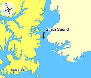
Smith Sound is an Arctic sea passage between Greenland and Nunavut's northernmost island, Ellesmere Island. It links Baffin Bay with Kane Basin and forms part of the Nares Strait. On the Canadian side it extends from Cape Sabine in the north to Cape Isabella in the south.

Harry Whitney was an American sportsman, adventurer, and author. He traveled to northern Greenland with Robert Peary in 1908, staying over the winter with the Inughuit at Etah and Annoatok. In the spring of 1909 Whitney found himself at the center of the controversy between Frederick Cook and Peary over who had reached the North Pole first. A year after his return, he published a book on the trip. He is sometimes confused with his contemporary Harry Payne Whitney, who was no relation.

Etah is an abandoned settlement in the Avannaata municipality in northern Greenland. It was a starting point of discovery expeditions to the North Pole and the landing site of the last migration of the Inuit from the Canadian Arctic.

Farthest North describes the most northerly latitude reached by explorers, before the first successful expedition to the North Pole rendered the expression obsolete. The Arctic polar regions are much more accessible than those of the Antarctic, as continental land masses extend to high latitudes and sea voyages to the regions are relatively short.

Independence Fjord or Independence Sound is a large fjord or sound in the eastern part of northern Greenland. It is about 200 km (120 mi) long and up to 30 km (19 mi) wide. Its mouth, opening to the Wandel Sea of the Arctic Ocean is located at 82°15′N21°54′W.

Arctic exploration is the physical exploration of the Arctic region of the Earth. It refers to the historical period during which mankind has explored the region north of the Arctic Circle. Historical records suggest that humankind have explored the northern extremes since 325 BC, when the ancient Greek sailor Pytheas reached a frozen sea while attempting to find a source of the metal tin. Dangerous oceans and poor weather conditions often fetter explorers attempting to reach polar regions, and journeying through these perils by sight, boat, and foot has proven difficult.
Melville Glacier, is a glacier in northwestern Greenland. Administratively it belongs to the Avannaata municipality.
Hart Glacier, is a glacier in northwestern Greenland. Administratively it belongs to the Avannaata municipality.
Sharp Glacier, is a glacier in northwestern Greenland. Administratively it belongs to the Avannaata municipality.
Hubbard Glacier, is a glacier in northwestern Greenland. Administratively it belongs to the Avannaata municipality.

Bowdoin Fjord is a fjord in northern Greenland. To the south the fjord opens into the Inglefield Gulf of the Baffin Bay.

Cape Cannon is a headland in the Lincoln Sea, Arctic Ocean, North Greenland. Administratively it is part of the Northeast Greenland National Park.
Wyckoff Land is an area or peninsula in Peary Land, Northern Greenland.
Cape Clarence Wyckoff, also known as Cape Wyckoff, is a broad headland in the Wandel Sea, Arctic Ocean, northernmost Greenland. Administratively it is part of the Northeast Greenland National Park.
Abandoned sites in Greenland | ||||||||||||||
|---|---|---|---|---|---|---|---|---|---|---|---|---|---|---|
|
|  | ||||||||||||
|
| |||||||||||||
| ||||||||||||||
| ||||||||||||||
| Polar exploration | ||||||||||||||
| Paleo-Eskimo | ||||||||||||||
78°31′28.2″N72°24′10.8″W / 78.524500°N 72.403000°W
| | This Greenland location article is a stub. You can help Wikipedia by expanding it. |