Aappilattoq, Kujalleq

Last updated
Aappilattoq
Aappilattoq.jpg
Southern Greenland.png
Red pog.svg
Aappilattoq
Location on the southern tip of Greenland
Coordinates: 60°09′01″N44°17′06″W / 60.15028°N 44.28500°W / 60.15028; -44.28500 Coordinates: 60°09′01″N44°17′06″W / 60.15028°N 44.28500°W / 60.15028; -44.28500
StateFlag of Denmark (state).svg  Kingdom of Denmark
Constituent country Flag of Greenland.svg  Greenland
Municipality Kujalleq-coat-of-arms.svg Kujalleq
Government
[1]
  MayorHans Levisen
Population
 (2020)
  Total100
Time zone UTC-03
Postal code
3922 Nanortalik

Aappilattoq (old spelling: Augpilagtoq) is a village in the Kujalleq municipality in southern Greenland. The name means "red", after the red mountain rising above the settlement in the Greenlandic language. The settlement had 100 inhabitants in 2020. [2]

Contents

The area of Aappilattoq has been inhabited since the 19th century, but the present-day village was founded in 1922.

The main occupations and sources of income are hunting and fishing.

Infrastructure and governance

View from the shop towards the church, summer 2017 Aappilattoq, Kujalleq, Greenland, summer 2017.jpg
View from the shop towards the church, summer 2017

The median age of the settlement is 31.4 years, the lowest in the municipality. [3] The main settlement service house is maintained and operated by the Kujalleq municipality. There is also a general store operated by KNI, and a general repairs workshop. The local fire station is operated by Nanortalik fire department.

Church and cemetery, 2017 Church and cemetery, Aappilattoq, 2017.jpg
Church and cemetery, 2017

The settlement also houses a school, Jaajap atuarfia, [4] which had 22 pupils in 2006. [5] Appilattoq also has its own church.

Church interior, 2017 Pews in church, Aappilattoq, 2017.jpg
Church interior, 2017

Together with the settlements Narsarmijit and Tasiusaq the village is governed by a joint council. The head of the council is Hans Levisen. [6]

Until December 31, 2008, the settlement belonged to the Nanortalik municipality. Since January 1, 2009, the settlement has been part of the Kujalleq municipality, when the former municipalities of Qaqortoq, Narsaq, and Nanortalik ceased to exist as administrative entities.

Transportation

The settlement has a heliport operated by Air Greenland. The village is served as part of government contract, with mostly cargo helicopter flights. The main transportation routes are via air or sea. The village is practically inaccessible via land due to its remote location and the surrounding mountain region. Every summer a few large or very large cruise ships go through Prince Christian Sound and pass Aappilattoq. The largest cruise ship believed to have passed by is Voyager of the Seas in September 2022 [7]

Geography

Aappilattoq is located east of Nanortalik, roughly 50 km north of Cape Farewell, the southern cape of Greenland. [8] including Prince Christian Sound, a 100 km long, steep and 12-2 km wide fjord.

Mountains

Unlike most other summits in the area, these almost 2,000 m peaks near Aappilattoq are unglaciated. Aappilattoq mountains 1.JPG
Unlike most other summits in the area, these almost 2,000 m peaks near Aappilattoq are unglaciated.
Steep rock walls dominate the landscape near Aappilattoq. Aappilattoq mountains 2.JPG
Steep rock walls dominate the landscape near Aappilattoq.

Climate

Aappilatoq has a wet tundra climate (ET) with heavy precipitation and cold to very cold weather year-round.

Climate data for Aappilatoq
MonthJanFebMarAprMayJunJulAugSepOctNovDecYear
Average high °C (°F)−2.9
(26.8)
−2.4
(27.7)
−1.9
(28.6)
1.6
(34.9)
5.2
(41.4)
8.5
(47.3)
10.7
(51.3)
10.3
(50.5)
7.1
(44.8)
2.8
(37.0)
−0.1
(31.8)
−2.3
(27.9)
3.1
(37.5)
Daily mean °C (°F)−5.8
(21.6)
−5.4
(22.3)
−4.8
(23.4)
−1.4
(29.5)
2.3
(36.1)
5.0
(41.0)
7.1
(44.8)
6.8
(44.2)
4.2
(39.6)
0.4
(32.7)
−2.6
(27.3)
−5.0
(23.0)
0.1
(32.1)
Average low °C (°F)−8.6
(16.5)
−8.3
(17.1)
−7.7
(18.1)
−4.3
(24.3)
−0.6
(30.9)
1.6
(34.9)
3.6
(38.5)
3.4
(38.1)
1.3
(34.3)
−1.9
(28.6)
−5.1
(22.8)
−7.6
(18.3)
−2.8
(26.9)
Average rainfall mm (inches)151
(5.9)
142
(5.6)
124
(4.9)
139
(5.5)
114
(4.5)
114
(4.5)
111
(4.4)
133
(5.2)
168
(6.6)
143
(5.6)
158
(6.2)
157
(6.2)
1,654
(65.1)
Source: Climate-Data.org [9]

Population

Most towns and settlements in southern Greenland exhibit negative growth patterns over the last two decades, with many settlements rapidly depopulating. The population of Aappilattoq has decreased by more than a third relative to the 1990 levels, and by over 20 percent relative to the 2000 levels. [10]

Aappilattoq-kujalleq-population-dynamics.png
Aappilattoq population growth dynamics in the last two decades. Source: Statistics Greenland [10]

Related Research Articles

<span class="mw-page-title-main">Narsarsuaq</span> Place in Greenland, Kingdom of Denmark

Narsarsuaq is a settlement in the Kujalleq municipality in southern Greenland. It had 123 inhabitants in 2020. There is a thriving tourism industry in and around Narsarsuaq, whose attractions include a great diversity of wildlife, gemstones, tours to glaciers, and an airfield museum.

<span class="mw-page-title-main">Narsaq</span> Place in Greenland, Kingdom of Denmark

Narsaq is a town in the Kujalleq municipality in southern Greenland. The name Narsaq is Kalaallisut for "Plain", referring to the shore of Tunulliarfik Fjord where the town is located.

<span class="mw-page-title-main">Nanortalik</span> Place in Greenland, Kingdom of Denmark

Nanortalik, formerly Nennortalik, is a town in Nanortalik Island, Kujalleq municipality, southern Greenland. With 1,185 inhabitants as of 2020, it is the eleventh-largest town in the country. The name Nanortalik means "Place of Polar Bears" or "Place Where the Polar Bears Go". It is the southernmost town in Greenland with a population of over 1,000.

Qaqortoq, formerly Julianehåb, is a city in the Kujalleq municipality in southern Greenland, located near Cape Thorvaldsen. With a population of 3,050 in 2020, it is the most populous town and the municipal capital in southern Greenland and the fourth or fifth-largest town on the island.

<span class="mw-page-title-main">Alluitsup Paa</span> Place in Greenland, Kingdom of Denmark

Alluitsup Paa is a village in the Kujalleq municipality in southern Greenland. Alluitsup Paa had 202 residents in 2020. Presently, the community's religious activities take place in Qaqortoq.

<span class="mw-page-title-main">Qassiarsuk</span> Place in Greenland, Kingdom of Denmark

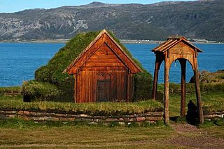
Qassiarsuk is a settlement in the Kujalleq municipality, in southern Greenland. Its population was 39 in 2020. Qassiarsuk is part of the Kujataa World Heritage Site, due to its historical importance as the homestead of Erik the Red and its unique testimony to Greenlandic farming.

Eqalugaarsuit is a settlement in the Kujalleq municipality in southern Greenland, located southeast of Qaqortoq and northwest of Alluitsup Paa. Its population was 49 in 2020.

<span class="mw-page-title-main">Tasiusaq, Kujalleq</span> Place in Greenland, Kingdom of Denmark

Tasiusaq is a settlement in the Kujalleq municipality in southern Greenland, founded in 1933. It is located at the Tasermiut Fjord, east of Nanortalik. Its population was 53 in 2020. In the Greenlandic language, the name of the settlement means "like a lake", referring to the lake-looking bay it situated on. The inhabitants call it "Tasiisaq", which is the local dialect.

Narsarmijit, formerly Narsaq Kujalleq and Frederiksdal, is a settlement in southern Greenland. It is located in the Kujalleq municipality near Cape Thorvaldsen. Its population was 66 in 2020. There has been a slow but steady pattern of emigration since the late 1950s.

<span class="mw-page-title-main">Ammassivik</span> Place in Greenland, Kingdom of Denmark

Ammassivik is a settlement in the Kujalleq municipality in southern Greenland. The modern name is the Kalaallisut for "where you catch ammassaat (capelin)". Its population was 74 in 2010 and 32 in 2020.

<span class="mw-page-title-main">Saarloq</span> Place in Greenland, Kingdom of Denmark

Saarloq is a settlement in the Kujalleq municipality in southern Greenland. Its population was 21 in 2020. It is located on a small island with the same name off the Labrador Sea coast, at the mouth of the Qaqortoq Fjord, west of Alluitsup Paa and 20 km south of Qaqortoq.

<span class="mw-page-title-main">Qassimiut</span> Place in Greenland, Kingdom of Denmark

Qassimiut is a settlement in the Kujalleq municipality in southern Greenland. The settlement was founded in 1835 as a trading station. With a population of 20 in 2020, it is the smallest organized, permanent settlement in Greenland.

<span class="mw-page-title-main">Kujalleq</span> Municipality of Greenland

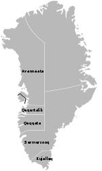
Kujalleq is a municipality on the southern tip of Greenland, operational from 1 January 2009. The administrative center of the municipality is in Qaqortoq.

Nanortalik Heliport is a heliport in the eastern part of Nanortalik, a town in the Kujalleq municipality in southern Greenland.

Aappilattoq Heliport is a heliport in Aappilattoq, a village in the Upernavik Archipelago of Avannaata municipality in northwestern Greenland. The heliport is considered a helistop, and is served by Air Greenland as part of government contract.

Aappilattoq Heliport is a heliport in Aappilattoq, a village in the Kujalleq municipality in southern Greenland. The heliport is considered a helistop, and is served by Air Greenland as part of a government contract.

Narsaq Kujalleq Heliport or Narsarmijit Heliport is a heliport in Narsaq Kujalleq, a village in the Kujalleq municipality in southern Greenland. The heliport is considered a helistop, and is served by Air Greenland as part of a government contract.

Upernavik Archipelago is a vast coastal archipelago in the Avannaata municipality in northwestern Greenland, off the shores of northeastern Baffin Bay. The archipelago extends from the northwestern coast of Sigguup Nunaa peninsula in the south at approximately 71°50′N56°00′W to the southern end of Melville Bay in the north at approximately 74°50′N57°30′W.

<span class="mw-page-title-main">Prince Christian Sound</span> Body of water

The Prince Christian Sound is a waterway in Southern Greenland. It separates the mainland from Sammisoq and other islands of the Cape Farewell Archipelago near the southernmost tip of Greenland. The name was given in honour of the prince, later king Christian VIII of Denmark.

References

  1. Kujalleq Municipality Archived July 18, 2011, at the Wayback Machine (in Danish)
  2. "Population by Localities". Statistical Greenland. Retrieved 7 April 2020.
  3. "Nanortalik Kommuneplan 2008-2018" (PDF). Archived from the original (PDF) on 2012-03-23. Retrieved June 4, 2012.
  4. "Folkeskolerne" (in Danish). Attat and KIIIP, Greenland Homerule Government. Archived from the original on February 7, 2012. Retrieved May 24, 2012.
  5. "Skole og Daginstitutioner - Aappilattoq" (in Danish). Kujalleq Municipality. Archived from the original on March 23, 2012. Retrieved May 11, 2011.
  6. "Aappilattoq - Kommune Kujalleq" (in Danish). Archived from the original on July 18, 2011. Retrieved May 11, 2011.
  7. "Voyager Of The Seas - Aappilattoq Greenland #shorts". youtube. Sep 21, 2022. Retrieved 16 October 2022.
  8. Greenland and the Arctic. By Etain O'Carroll and Mark Elliott. Lonely Planet 2005. ISBN   1-74059-095-3.
  9. "Climate: Aappilatoq". Climate-Data.org. Retrieved January 30, 2021.
  10. 1 2 "Statistics Greenland". Statistics Greenland. Archived from the original on August 12, 2011. Retrieved May 11, 2011.