Kuummiit Kuummiut | |
|---|---|
 View of Kuummiit | |
 Kuummiit Location within Greenland | |
| Coordinates: 65°51′55″N37°00′30″W / 65.86528°N 37.00833°W | |
| State | |
| Constituent country | |
| Municipality | |
| Founded | 1915 |
| Government | |
| • Mayor | Anders Sanimuinnaq |
| Elevation | 49 m (161 ft) |
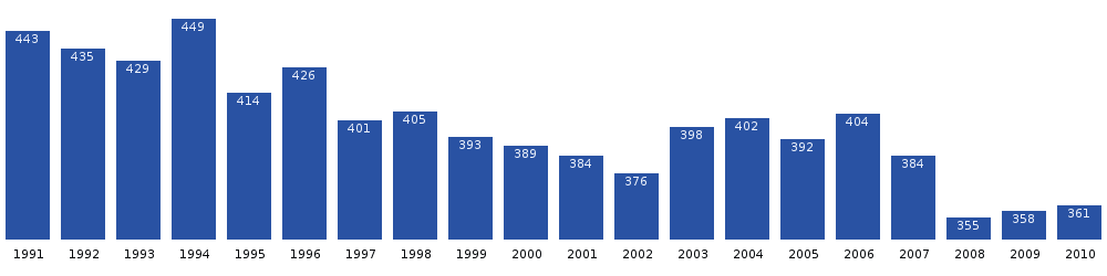
| Population (2020) | |
• Total | 248 [2] |
| Time zone | UTC−02:00 (WGT) |
| • Summer (DST) | UTC−01:00 (WGST) |
| Postal code | 3913 Tasiilaq |
Kuummiit (Kalaallisut: Kuummiut) is a settlement in the Sermersooq municipality in southeastern Greenland. Founded in 1915, it had 248 inhabitants in 2020. [2]