Kapisillit Lakskaj | |
|---|---|
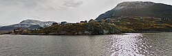 | |
 Kapisillit Location within Greenland | |
| Coordinates: 64°26′10″N50°16′10″W / 64.43611°N 50.26944°W | |
| State | |
| Constituent country | |
| Municipality | |
| Government | |
| • Mayor | Morten Johnsen |
| Population (2025) | |
• Total | 52 |
| Time zone | UTC−02:00 (Western Greenland Time) |
| • Summer (DST) | UTC−01:00 (Western Greenland Summer Time) |
| Postal code | 3900 Nuuk |
Kapisillit (Danish: Lakskaj) is a settlement in the Sermersooq municipality in southwestern Greenland. The settlement had 43 inhabitants in 2024. [2] Kapisillit means "the salmon" in the Greenlandic language (Danish : laks, laksen). [3] The name refers to the belief that the only spawning-ground for salmon in Greenland is a river near the settlement. [4]

